Brownwood is a city in and the county seat of Brown County, Texas, United States. The population was 18,862 at the 2020 census. Brownwood is located in the Northern Texas Hill Country and is home to Howard Payne University that was founded in 1889.
Lake Brownwood is a census-designated place (CDP) located in Brown County in central Texas, United States. The population was 1,532 at the 2010 census.

Lake Buchanan was formed by the construction of Buchanan Dam by the Lower Colorado River Authority to provide a water supply for the region and to provide hydroelectric power. Buchanan Dam, a structure over 2 mi (3.2 km) in length, was completed in 1939. Lake Buchanan was the first of the Texas Highland Lakes to be formed, and with 22,333 acres of surface water, it is also the largest. The surface of the lake includes area in both Burnet and Llano Counties. The lake is west of the city of Burnet, Texas.

The Little Tennessee River is a 135-mile (217 km) tributary of the Tennessee River that flows through the Blue Ridge Mountains from Georgia, into North Carolina, and then into Tennessee, in the southeastern United States. It drains portions of three national forests— Chattahoochee, Nantahala, and Cherokee— and provides the southwestern boundary of the Great Smoky Mountains National Park.

The Tioga River is a tributary of the Chemung River, approximately 58 miles (93 km) long, in northern Pennsylvania and western New York in the United States. It drains a region of ridges in the northern Allegheny Plateau in the watershed of the Susquehanna River. It is a Northern flowing river

The Feather River is the principal tributary of the Sacramento River, in the Sacramento Valley of Northern California. The river's main stem is about 73 miles (117 km) long. Its length to its most distant headwater tributary is just over 210 miles (340 km). The main stem Feather River begins in Lake Oroville, where its four long tributary forks join—the South Fork, Middle Fork, North Fork, and West Branch Feather Rivers. These and other tributaries drain part of the northern Sierra Nevada, and the extreme southern Cascades, as well as a small portion of the Sacramento Valley. The total drainage basin is about 6,200 square miles (16,000 km2), with approximately 3,604 square miles (9,330 km2) above Lake Oroville.

The Caney Fork River is a river that flows through central Tennessee in the United States, draining a substantial portion of the southwestern Cumberland Plateau and southeastern Highland Rim regions. It is a major tributary of the Cumberland River, and is part of the Cumberland, Ohio and Mississippi basins. The river is 143 miles (230 km) long, and its watershed covers 1,771 square miles (4,590 km2) in eleven counties. Monterey, Baxter, Sparta, Smithville, McMinnville, Altamont, Spencer and Gordonsville are among the towns that are at least partially drained by the river.
Moses Lake is a lake and reservoir along the course of Crab Creek, in Washington state, USA.
Lake Ray Hubbard, formerly Eastern Dallas Lake or Forney Lake, is a freshwater impoundment (reservoir) located in Dallas, Texas in the counties of Dallas, Kaufman, Collin, and Rockwall, just north of the City of Forney. It was created by the construction of the Rockwall-Forney Dam, which impounded the East Fork Trinity River.

Lake Casa Blanca is a reservoir on the Chacon Creek, 5 miles (8 km) northeast of downtown Laredo, Texas, United States. The reservoir was formed in 1951 by the construction of a dam to provide recreational opportunities for the residents of Webb County. The current dam is the second built across the creek - a previous dam built in 1946 failed the following year during the initial attempted impounding of a reservoir. There are residential properties along the lake as well as a Texas state park. Surrounding the lake is a 525-acre (212 ha) park that was operated jointly by the City of Laredo and Webb County before it was leased by the state in 1990 and opened in March 1991 as the Lake Casa Blanca International State Park. Lake Casa Blanca is fed by the Chacon Creek and San Ygnacio Creek.

Wright Patman Lake is a reservoir in northeast Texas in the United States. The lake is a U.S. Army Corps of Engineers reservoir formed on the Sulphur River in Bowie and Cass counties by Wright Patman Dam. The reservoir provides flood control and water conservation for the communities downstream from the dam. The lake is also a popular recreational destination. The Bowie County side of the lake is part of the Texarkana metropolitan area.

Boyne River is a stream in Northern Michigan, named for the River Boyne in Leinster, Ireland. Together with the north and south branches, the river system has approximately 22 miles (35 km) of mainstream and the water basin drains 40,320 acres (163.2 km2). Boyne River is Lake Charlevoix's second-largest tributary, after the Jordan River.

Barker Reservoir is a flood control structure in Houston, Texas which prevents downstream flooding of Buffalo Bayou, the city's principal river. The reservoir operates in conjunction with Addicks Reservoir to the northeast, which impounds Mayde and Bear Creeks, two tributaries of the Buffalo. Both reservoirs were authorized under the Rivers and Harbors Act of June 20, 1938, which were modified by the Flood Control Acts of August 11, 1938; September 3, 1954; and October 27, 1965.
Jim Ned Creek is a river in Texas. The stream rises outside of Tuscola and flows southeast for approximately 70 miles to Pecan Bayou at Lake Brownwood. Jim Need Creek was dammed in 1966 to form Lake Coleman.
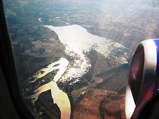
Pecan Bayou is a slow-moving stream in Callahan County, Texas. The stream is fed by over twenty creeks and is one of the major tributaries of the Colorado River in Texas. It may be the westernmost bayou in the United States. A dam on Pecan Bayou seven miles north of Brownwood forms Lake Brownwood. Below Lake Brownwood, the stream flows through Brownwood and Early, Texas into western Mills county before the confluence with the Colorado River about 8 miles west of Goldthwaite, Texas.
Lake Merritt is a small, private manmade lake on Brown's Creek, located about 7 miles north of Goldthwaite, Texas in Mills County. Initially constructed by the Santa Fe Railway Company as a reservoir for their steam engines, the lake is now used for recreation. Found at an elevation of 1,129 feet (344 m).
San Vicente Reservoir is a reservoir created by the San Vicente Dam in San Diego County, California. It is located in the Cuyamaca Mountains, approximately 4.3 miles (6.9 km) north of Lakeside off California State Route 67.
Thunderbird Bay is a census-designated place (CDP) in Brown County in central Texas, United States. The population was 663 at the 2010 census.
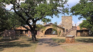
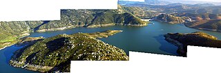
Lake Brownwood State Park is a state park located on the shore of Lake Brownwood in Brown County, Texas, United States and is administered by the Texas Parks and Wildlife Department. The 537.5 acre park was acquired by deed from the Brown County Water Improvement District No. 1 in 1933. The Civilian Conservation Corps (CCC) developed the park between 1934 and 1942. The park opened in 1938.