Lake Brownwood, Texas

Last updated

Lake Brownwood, Texas
TXMap-doton-LakeBrownwood.PNG
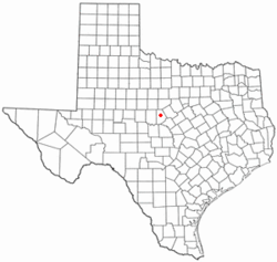
Location of Lake Brownwood, Texas
Brown County LakeBrownwood.svg
Coordinates: 31°49′08″N99°06′57″W / 31.81889°N 99.11583°W / 31.81889; -99.11583
Country United States
State Texas
County Brown
Area
  Total6.8 sq mi (17.5 km2)
  Land5.7 sq mi (14.7 km2)
  Water1.1 sq mi (2.8 km2)
Elevation
[1]
1,483 ft (452 m)
Population
 (2020)
  Total1,462
  Density220/sq mi (84/km2)
Time zone UTC-6 (Central (CST))
  Summer (DST) UTC-5 (CDT)
ZIP code
76801
Area code 325
FIPS code 48-40456 [2]
GNIS feature ID2408534 [1]

Lake Brownwood is a census-designated place (CDP) located in Brown County in central Texas, United States. The population was 1,532 at the 2010 census. [3]

Contents

Geography

Lake Brownwood dam Brownwood Dam33.jpg
Lake Brownwood dam

The Lake Brownwood CDP is located in western Brown County along the western arm of Lake Brownwood, a reservoir on Jim Ned Creek and Pecan Bayou. The CDP is 13 miles (21 km) northwest of Brownwood, the county seat.

According to the United States Census Bureau, the CDP has a total area of 6.8 square miles (17.5 km2), of which 5.7 square miles (14.7 km2) are land and 1.1 square miles (2.8 km2), or 15.77%, are covered by water. [3]

Demographics

Historical population
CensusPop.Note
2000 1,694
2010 1,532−9.6%
2020 1,462−4.6%
U.S. Decennial Census [4]
1850–1900 [5] 1910 [6]
1920 [7] 1930 [8] 1940 [9]
1950 [10] 1960 [11] 1970 [12]
1980 [13] 1990 [14] 2000 [15]
2010 [16]

2020 census

Lake Brownwood racial composition [17]
(NH = Non-Hispanic) [lower-alpha 1]
RaceNumberPercentage
White (NH)1,15879.21%
Black or African American (NH)322.19%
Native American or Alaska Native (NH)110.75%
Asian (NH)70.48%
Some Other Race (NH)10.07%
Mixed/Multi-Racial (NH)392.67%
Hispanic or Latino 21414.64%
Total1,462

As of the 2020 United States census, there were 1,462 people, 580 households, and 347 families residing in the CDP.

2000 census

As of the census [2] of 2000, 1,694 people, 723 households, and 493 families resided in the CDP. The population density was 295.9 inhabitants per square mile (114.2/km2). The 1,043 housing units averaged 182.2 per square mile (70.4/km2). The racial makeup of the CDP was 89.49% White, 1.48% African American, 0.53% Native American, 0.06% Pacific Islander, 6.20% from other races, and 2.24% from two or more races. Hispanics or Latinos of any race were 8.97% of the population.

Of the 723 households, 25.3% had children under the age of 18 living with them, 56.4% were married couples living together, 9.1% had a female householder with no husband present, and 31.7% were not families. About 27.7% of all households were made up of individuals, and 11.3% had someone living alone who was 65 years of age or older. The average household size was 2.34 and the average family size was 2.80.

In the CDP, the population was distributed as 23.0% under the age of 18, 7.1% from 18 to 24, 24.3% from 25 to 44, 28.7% from 45 to 64, and 16.9% who were 65 years of age or older. The median age was 42 years. For every 100 females, there were 102.9 males. For every 100 females age 18 and over, there were 98.6 males.

The median income for a household in the CDP was $26,286, and for a family was $29,280. Males had a median income of $25,380 versus $17,946 for females. The per capita income for the CDP was $13,289. About 18.4% of families and 17.7% of the population were below the poverty line, including 25.2% of those under age 18 and 8.9% of those age 65 or over.
Related Research Articles

<span class="mw-page-title-main">Lakehills, Texas</span> CDP in Texas, United States

Lakehills is a census-designated place (CDP) in Bandera County, Texas, United States. The population was 5,295 at the 2020 census, making it the most populous place in Bandera County. It is part of the San Antonio Metropolitan Statistical Area.

<span class="mw-page-title-main">Wyldwood, Texas</span> Census-designated place in Bastrop County, Texas, United States

Wyldwood is a census-designated place (CDP) in Bastrop County, Texas, United States. The population was 3,694 at the 2020 census.

<span class="mw-page-title-main">Arroyo Colorado Estates, Texas</span> CDP in Texas, United States

Arroyo Colorado Estates is a census-designated place (CDP) in Cameron County, in the U.S. state of Texas. The population was 997 at the 2010 census. It is part of the Brownsville–Harlingen Metropolitan Statistical Area.

<span class="mw-page-title-main">Bixby, Texas</span> CDP in Texas, United States

Bixby is a census-designated place (CDP) in Cameron County, Texas, United States. The population was 352 at the 2020 census. It is part of the Brownsville–Harlingen Metropolitan Statistical Area.

<span class="mw-page-title-main">Lozano, Texas</span> Census-designated place in Texas, United States

Lozano is a census-designated place (CDP) in Cameron County, Texas, United States. The population was 404 at the 2010 census, up from 324 at the 2000 census. By the 2020 census, the population went drastically down to 174. It is part of the Brownsville–Harlingen Metropolitan Statistical Area.

<span class="mw-page-title-main">Olmito, Texas</span> Census-designated place in Texas, United States

Olmito is a census-designated place (CDP) in Cameron County, Texas, United States. Olmito is Spanish for "little elm". The population was 1,021 at the 2020 census. It is part of the Brownsville–Harlingen Metropolitan Statistical Area. Olmito is the self-described "mesquite capital of the world."

<span class="mw-page-title-main">Reid Hope King, Texas</span> Census-designated place in Texas, United States

Reid Hope King is a census-designated place (CDP) in Cameron County, Texas, United States. The population was 667 at the 2020 census. It is part of the Brownsville–Harlingen Metropolitan Statistical Area.

<span class="mw-page-title-main">Solis, Texas</span> Census-designated place in Texas, United States

Solis is a census-designated place (CDP) in Cameron County, Texas, United States. The population was 722 at the 2020 census. It is part of the Brownsville–Harlingen Metropolitan Statistical Area.

<span class="mw-page-title-main">Canyon Lake, Texas</span> CDP in Texas, United States

Canyon Lake is a census-designated place (CDP) in Comal County, Texas, United States. The population was 31,124 at the 2020 census. It is part of the San Antonio Metropolitan Statistical Area.

<span class="mw-page-title-main">Indian Hills, Texas</span> Census-designated place in Texas

Indian Hills is a census-designated place (CDP) in Hidalgo County, Texas, United States. At the 2020 United States Census, the population was 2,694. It is part of the McAllen–Edinburg–Mission Metropolitan Statistical Area.

<span class="mw-page-title-main">Laguna Seca, Texas</span> Census-designated place in Texas

Laguna Seca is a census-designated place (CDP) in Hidalgo County, Texas, United States. The population was 232 at the 2020 United States Census. It is part of the McAllen–Edinburg–Mission Metropolitan Statistical Area.

<span class="mw-page-title-main">Monte Alto, Texas</span> Census-designated place in Texas

Monte Alto is a census-designated place (CDP) in Hidalgo County, Texas, United States. The population was 1,930 at the 2020 census. It is part of the McAllen–Edinburg–Mission Metropolitan Statistical Area.

<span class="mw-page-title-main">Pecan Plantation, Texas</span> Census-designated place in Texas, United States

Pecan Plantation is an unincorporated community and census-designated place (CDP) in southeastern Hood County, Texas, United States. Its population was 5,294 at the 2010 census, up from 3,544 at the 2000 census. It is part of the Granbury, Texas, micropolitan statistical area.

<span class="mw-page-title-main">South Toledo Bend, Texas</span> CDP in Texas, United States

South Toledo Bend is a census-designated place (CDP) in Newton County, Texas, United States. The population was 434 at the 2020 census, down from 524 at the 2010 census.

<span class="mw-page-title-main">El Refugio, Texas</span> CDP in Texas, United States

El Refugio is a census-designated place (CDP) in Starr County, Texas, United States. The population was 407 at the 2020 census. El Refugio gained area in the 2010 census.

<span class="mw-page-title-main">Falcon Heights, Texas</span> CDP in Texas, United States

Falcon Heights is a census-designated place (CDP) in Starr County, Texas, United States. The population was 18 at the 2020 census, down from 53 at the 2010 census.

<span class="mw-page-title-main">La Puerta, Texas</span> CDP in Texas, United States

La Puerta is a census-designated place (CDP) in Starr County, Texas, United States. The population was 638 at the 2020 census, an increase from the figure of 632 tabulated in 2010 census.

<span class="mw-page-title-main">San Isidro, Texas</span> CDP in Texas, United States

San Isidro is a census-designated place (CDP) in Starr County, Texas, United States. The population was 240 at the 2010 census. The town is named for St. Isidore the Laborer, the patron saint of farmers. A large Southwestern Barrel Cactus growing just east of town is said to be the largest in Texas.

<span class="mw-page-title-main">Oilton, Texas</span> Census-designated place in Webb County, Texas, United States

Oilton is a census-designated place (CDP) in Webb County, Texas, United States. The population was 152 at the 2010 census. The community is within the boundary of Webb Consolidated Independent School District and is home to the Oilton Elementary School.

<span class="mw-page-title-main">Falcon Lake Estates, Texas</span> CDP in Texas, United States

Falcon Lake Estates is a census-designated place (CDP) in Zapata County, Texas, United States. The population was 962 at the 2020 census.

References

  1. 1 2 U.S. Geological Survey Geographic Names Information System: Lake Brownwood, Texas
  2. 1 2 "U.S. Census website". United States Census Bureau . Retrieved January 31, 2008.
  3. 1 2 "Geographic Identifiers: 2010 Demographic Profile Data (G001): Lake Brownwood CDP, Texas". U.S. Census Bureau, American Factfinder. Archived from the original on February 12, 2020. Retrieved April 22, 2014.
  4. "Decennial Census by Decade". United States Census Bureau .
  5. "1900 Census of Population - Population of Texas By Counties And Minor Civil Divisions" (PDF). United States Census Bureau .
  6. "1910 Census of Population - Supplement for Texas" (PDF). United States Census Bureau .
  7. "1920 Census of Population - Number of Inhabitants - Texas" (PDF). United States Census Bureau .
  8. "1930 Census of Population - Number of Inhabitants - Texas" (PDF). United States Census Bureau .
  9. "1940 Census of Population - Number of Inhabitants - Texas" (PDF). United States Census Bureau .
  10. "1950 Census of Population - Number of Inhabitants - Texas" (PDF). United States Census Bureau .
  11. "1960 Census of Population - Number of Inhabitants - Texas" (PDF). United States Census Bureau .
  12. "1970 Census of Population - Number of Inhabitants - Texas" (PDF). United States Census Bureau .
  13. "1980 Census of Population - Number of Inhabitants - Texas" (PDF). United States Census Bureau .
  14. "1990 Census of Population - Population and Housing Unit Counts - Texas" (PDF). United States Census Bureau .
  15. "2000 Census of Population - Population and Housing Unit Counts - Texas" (PDF). United States Census Bureau .
  16. "2010 Census of Population - Population and Housing Unit Counts - Texas" (PDF). United States Census Bureau .
  17. "Explore Census Data". data.census.gov. Retrieved May 20, 2022.
  18. https://www.census.gov/ [ not specific enough to verify ]
  19. "About the Hispanic Population and its Origin". www.census.gov. Retrieved May 18, 2022.
  1. Note: the US Census treats Hispanic/Latino as an ethnic category. This table excludes Latinos from the racial categories and assigns them to a separate category. Hispanics/Latinos can be of any race. [18] [19]