

Lake Connewarre State Wildlife Reserve (LCSWR) is a 3411.1 ha Park in Victoria, Australia, that contains a diverse range of unique and significant ecosystems including a river, tidal delta, lakes, swamps, salt marshes and grasslands. [1]
Lake Connewarre State Wildlife Reserve (LCSWR) is a 3411.1 ha Park in Victoria, Australia, that contains a diverse range of unique and significant ecosystems including a river, tidal delta, lakes, swamps, salt marshes and grasslands. [1]
Lake Connewarre State Wildlife Reserve is situated on the lower reaches of the Barwon River on Victoria's Bellarine Peninsula, approximately 8 km south-east of Geelong and 65 km south-west of Melbourne. The Reserve holds the largest area of remnant vegetation on the Bellarine Peninsula and contains the most extensive example of Wilsonia herblands and Distichlis grasslands in Australia. [2] As well as the saline and tidally affected Lake Connewarre itself, the reserve includes the adjacent freshwater Reedy Lake and the ephemeral Murtnaghurt Lagoon. Part of LCSWR is designated a State Game Reserve and is available for duck and quail hunting each year. Other recreational uses include fishing, windsurfing, canoeing and nature study.
Campbell Point protrudes into Lake Connewarre and contains the oldest dated Aboriginal archaeological remains on the Bellarine Peninsula. The deposits have been dated at between 3600 and 5200 years old and are considered significant for their demonstration of shellfish gathering which was uncommon on the central coast of Victoria. [3] [4]
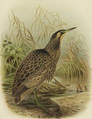
It is home to over 150 bird species. Several migratory species are listed the under international agreements Japan Australia Migratory Bird Agreement and the China Australia Migratory Bird Agreement. Twelve plant and animal species are listed as threatened under Victoria's Flora and Fauna Guarantee Act 1988 including the orange-bellied parrot. According to The Action Plan for Australian Birds by the Natural Heritage Trust, the orange-bellied parrot ( Neophema chrysogaster) is critically endangered with approximately 180 mature birds remaining in the wild, and numbers continuing to decline. The reserve is part of the Bellarine Wetlands Important Bird Area, identified as such by BirdLife International because of its importance for orange-bellied parrots and for waterbirds. [5]
The Mud Islands reserve is located within Port Phillip, about 90 km (56 mi) south-west of Melbourne, Australia, lying 10 km (6.2 mi) inside Port Phillip Heads, 7 km (4.3 mi) north of Portsea and 9 km (5.6 mi) east of Queenscliff. The land area of about 50 hectares is made up of three low-lying islands surrounding a shallow tidal 35-hectare (86-acre) lagoon connected to the sea by three narrow channels. The shapes and configuration of the islands change over the years due to movement of sand by tidal currents.

St Leonards is a coastal township near Geelong, Victoria, Australia, at the eastern end of the Bellarine Peninsula and the northern end of Swan Bay. Situated 33 kilometres (21 mi) east of Geelong, St Leonards was a filming location for the Australian television series SeaChange.

The Bellarine Peninsula is a peninsula located south-west of Melbourne in Victoria, Australia, surrounded by Port Phillip, Corio Bay and Bass Strait. The peninsula, together with the Mornington Peninsula, separates Port Phillip Bay from Bass Strait. The peninsula itself was originally occupied by Indigenous Australian clans of the Wadawurrung nation, prior to European settlement in the early 19th century. Early European settlements were initially centred on wheat and grain agriculture, before the area became a popular tourist destination with most visitors arriving by paddle steamer on Port Phillip in the late 19th century.

Limeburners Bay, one of numerous bays in Port Phillip, lies in the southwest and adjoins Corio Bay, which abuts Geelong, the second largest city in Victoria, Australia. The bay was named after lime kilns, located on the east side of Corio Bay, used to burn limestone for making cement.
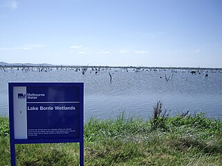
Lake Borrie Wetlands is a coastal wetland that is located in the Greater Geelong region of Victoria, Australia. The wetland is situated within the Western Treatment Plant at Werribee; administered by Melbourne Water.

Lake Victoria is a 139-hectare (340-acre) shallow saline lake on the Bellarine Peninsula, Victoria in Australia, close to the township of Point Lonsdale and part of the Lonsdale Lakes Nature Reserve administered by Parks Victoria.

The Swan Bay is a shallow, 30-square-kilometre (12 sq mi) marine embayment at the eastern end of the Bellarine Peninsula in Port Phillip, Victoria, Australia. The township of Queenscliff lies at its southern end, and St Leonards at its northern. It is partly separated from Port Phillip by Swan Island, Duck Island and Edwards Point. Most of the area is included in the Port Phillip Heads Marine National Park as well as being listed as a wetland of international importance under the Ramsar Convention as part of the Port Phillip Bay and Bellarine Peninsula Ramsar Site. The bay is part of the Swan Bay and Port Phillip Bay Islands Important Bird Area, identified as such by BirdLife International because of its importance for orange-bellied parrots, waders and seabirds.

Edwards Point is a 4 km long sand spit extending southwards between Swan Bay and Port Phillip Bay, at the eastern end of the Bellarine Peninsula, Victoria, Australia. It is about 115 km by road south-west of Melbourne and 40 km east of Geelong.

Point Wilson is a locality located on the northern shores of Corio Bay, Victoria. it is approximately 60 kilometres by road from Melbourne, and 25 kilometres by road from Geelong.

Lake Connewarre, a shallow estuarine 880-hectare (2,200-acre) lake on the Barwon River, is located on the Bellarine Peninsula southeast of Geelong in the Australian state of Victoria.
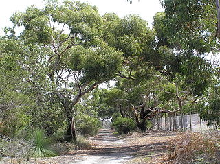
The Ocean Grove Nature Reserve is a rectangular, 1.43 km2 nature reserve next to the town of Ocean Grove and 25 km south-east of the city of Geelong, on the Bellarine Peninsula, Victoria, Australia. It contains the only significant remnant of native woodland on the Bellarine Peninsula as it was prior to European settlement and the extensive land clearing that ensued. It is surrounded by agricultural land and a housing estate and is managed by Parks Victoria. Records of its birdlife illustrate the changes occurring in an isolated woodland remnant.

Reedy Lake, historically also known as Lake Reedy, is a shallow 5.5-square-kilometre (2.1 sq mi) intermittent freshwater lake or swamp on the lower reaches of the Barwon River, on the Bellarine Peninsula southeast of Geelong in the Australian state of Victoria.
The Port Phillip Bay and Bellarine Peninsula Ramsar Site is one of the Australian sites listed under the Ramsar Convention as a wetland of international importance. It was designated on 15 December 1982, and is listed as Ramsar Site No.266. Much of the site is also part of either the Swan Bay and Port Phillip Bay Islands Important Bird Area or the Werribee and Avalon Important Bird Area, identified as such by BirdLife International because of their importance for wetland and waterbirds as well as for orange-bellied parrots. It comprises some six disjunct, largely coastal, areas of land, totalling 229 km2, along the western shore of Port Phillip and on the Bellarine Peninsula, in the state of Victoria. Wetland types protected include shallow marine waters, estuaries, freshwater lakes, seasonal swamps, intertidal mudflats and seagrass beds.

Murtnaghurt Lagoon, also known as Murtnaghurt Swamp or Lake Murtnaghurt, is a shallow, ephemeral wetland west of the town of Barwon Heads on the southern coast of the Bellarine Peninsula in Victoria, Australia. It comprises two enclosed depressions, elongated west-east and separated by a low ridge. The wetland is about 2 kilometres (1.2 mi) in length, and up to 600 metres (2,000 ft) wide, with 4.5 kilometres (2.8 mi) of shoreline enclosing an area of 81 hectares. It is connected by a narrow 2.7 kilometres (1.7 mi) palaeochannel extending from the lagoon northwards to the main tidal channel of the lower Barwon River.
The Spit Nature Conservation Reserve is a 300 ha nature reserve on the north-western shore of Port Phillip, a large bay in Victoria, Australia. It consists of public land set aside to conserve and protect species, communities, and habitats of indigenous plants and animals. It is adjacent to the Werribee Sewage Farm and is managed by Parks Victoria.
The Swan Bay and Port Phillip Bay Islands Important Bird Area comprises a cluster of disparate sites centred at the eastern end of the Bellarine Peninsula, and the southern end of Port Phillip, in Victoria, south-eastern Australia. As well as providing core wintering habitat for orange-bellied parrots, it is important for waders, or shorebirds, and seabirds.

The Werribee and Avalon Important Bird Area comprises some 37 km2 of coastal land along the northwestern shore of Port Phillip in the state of Victoria, in southeastern Australia. It is important for a wide variety of waterbirds.

The Yambuk Important Bird Area comprises a 10 km2 tract of coastal land fronting Bass Strait in south-western Victoria, south-eastern Australia. It lies some 20 km west of the town of Port Fairy and encompasses the lower reaches of the Eumeralla River and Lake Yambuk.
The Bellarine Wetlands Important Bird Area comprises a group of wetland sites, with a collective area of 46 km2, at the western end of the Bellarine Peninsula in Victoria, south-eastern Australia. The site is important for waterbirds and orange-bellied parrots.
The Point Cook Coastal Park covers an area of 863 hectares and includes the Cheetham Wetlands. The park extends from the RAAF Williams Point Cook Base northeast along the coast to the Laverton creek which comprises its northern boundary. The park is approximately 20 kilometres (12 mi) from Melbourne, Australia in a southwesterly direction along Port Phillip Bay. The park is adjoined by the Point Cook Marine Sanctuary, which extends around the point to the south and the east. The northwestern boundary to the park is residential housing.