The Simpson Desert is a large area of dry, red sandy plain and dunes in the Northern Territory, South Australia and Queensland in central Australia. It is the fourth-largest Australian desert, with an area of 176,500 km2 (68,100 sq mi).
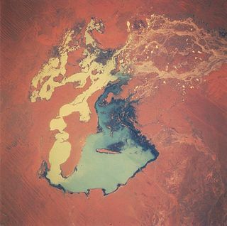
The Lake Eyre basin is a drainage basin that covers just under one-sixth of all Australia. It is the largest endorheic basin in Australia and amongst the largest in the world, covering about 1,200,000 square kilometres (463,323 sq mi), including much of inland Queensland, large portions of South Australia and the Northern Territory, and a part of western New South Wales. The basin is also one of the largest, least-developed arid zone basins with a high degree of variability anywhere. It supports only about 60,000 people and has no major irrigation, diversions or flood-plain developments. Low density grazing that sustains a large amount of wildlife is the major land use, occupying 82% of the total land within the basin. The Lake Eyre basin of precipitation to a great extent geographically overlaps the Great Artesian Basin underneath.

The Cooper Creek is a river in the Australian states of Queensland and South Australia. It was the site of the death of the explorers Burke and Wills in 1861. It is sometimes known as the Barcoo River from one of its tributaries and is one of three major Queensland river systems that flow into the Lake Eyre basin. The flow of the creek depends on monsoonal rains falling months earlier and many hundreds of kilometres away in eastern Queensland. It is 1,300 kilometres (810 mi) in length.
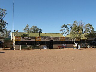
William Creek, Australia is located halfway on the Oodnadatta Track, 210 km (130 mi) north west of Marree and 166 km (103 mi) east of Coober Pedy in South Australia. The town has a permanent population of 10. William Creek is in the federal Division of Grey and the state electorate of Stuart. It is outside of council areas, and administered by the Outback Communities Authority.
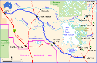
The Oodnadatta Track is an unsealed 614 km (382 mi) outback road in the Australian state of South Australia, connecting Marla in the north-west via Oodnadatta to Marree in the south-east. Along the way, the track passes the settlements of Oodnadatta and William Creek, the southern lake of the Kati Thanda-Lake Eyre National Park, and mound springs known as Freeling Springs, Strangways Springs, and The Bubbler and Blanche Cup.
Lake Gregory, or Paraku in the Walmajarri language, is a permanent brackish lake located in the Kimberley region of Western Australia, situated between the Great Sandy Desert and the Tanami Desert. Following monsoonal rains it may hold fresh water, but becomes more saline after a number of dry years.

Lake Frome / Munda is a large endorheic lake in the Australian state of South Australia to the east of the Northern Flinders Ranges. It is a large, shallow, unvegetated salt pan, 100 kilometres (62 mi) long and 40 kilometres (25 mi) wide, lying mostly below sea level and having a total surface area of 259,615 hectares. It only rarely fills with brackish water flowing down usually dry creeks in the Northern Flinders Ranges from the west, or exceptional flows down the Strzelecki Creek from the north.

Innamincka, formerly Hopetoun, is a township and locality in north-east South Australia. By air it is 820 kilometres north-east of the state capital, Adelaide, and 365 kilometres north-east of the closest town, Lyndhurst. It is 66 kilometres north-east of the Moomba Gas Refinery. The town lies within the Innamincka Regional Reserve and is surrounded by the Strzelecki Desert to the south and the Sturt Stony Desert to the north. It is linked by road to Lyndhurst via the Strzelecki Track, to the Birdsville Developmental Road via Cordillo Downs Road and Arrabury Road, and the Walkers Crossing Track to the Birdsville Track. The Walkers Crossing Track is closed in summer and only traversable in dry weather. The township is situated along the Cooper Creek, a part of the Lake Eyre basin.
Strzelecki Regional Reserve is a protected area located in the Australian state of South Australia in the gazetted localities of Lindon and Strzelecki Desert about 493 kilometres north-east of Port Augusta. It includes the Strzelecki Desert and the dry Strzelecki Creek bed. The regional reserve can only accessed via the historic Strzelecki Track. It is partly located on land that was included on the List of Wetlands of International Importance under the Ramsar Convention under the name Coongie Lakes in 1987. The regional reserve is classified as an IUCN Category VI protected area.

The Strzelecki Desert is located in the Far North Region of South Australia, South West Queensland and western New South Wales. It is positioned in the northeast of the Lake Eyre Basin, and north of the Flinders Ranges. Two other deserts occupy the Lake Eyre Basin—the Tirari Desert and the Simpson Desert.
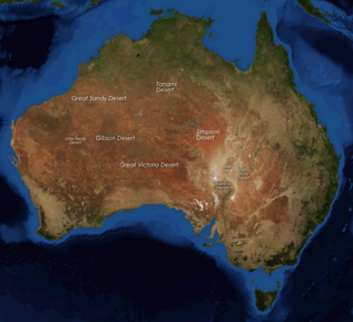
The deserts of Australia or the Australian deserts cover about 2,700,000 km2 (1,000,000 sq mi), or 18% of the Australian mainland, but about 35% of the Australian continent receives so little rain, it is practically desert. Collectively known as the Great Australian desert, they are primarily distributed throughout the Western Plateau and interior lowlands of the country, covering areas from South West Queensland, Far West region of New South Wales, Sunraysia in Victoria and Spencer Gulf in South Australia to the Barkly Tableland in Northern Territory and the Kimberley region in Western Australia.

The Tirari Desert is a 15,250 square kilometres (5,888 sq mi) desert in the eastern part of the Far North region of South Australia. It stretches 212 km from north to south and 153 km from east to west.

The Coongie Lakes is a freshwater wetland system located in the Far North region of South Australia. The 21,790-square-kilometre (8,410 sq mi) lakes system is located approximately 1,046 kilometres north of the Adelaide city centre. The wetlands includes lakes, channels, billabongs, shallow floodplains, deltas, and interdune swamps. It lies on the floodplain of Cooper Creek, an ephemeral river flowing through a desert landscape in the Lake Eyre Basin which rarely, after occasional large floods, empties into Lake Eyre. The wetland system has been recognised both as being of international importance by designation under the Ramsar Convention with a listing on 15 June 1987 and being nationally important within Australia with a listing in A Directory of Important Wetlands in Australia (DIWA). Its extent includes the regional town of Innamincka, the Malkumba-Coongie Lakes National Park, the Innamincka Regional Reserve, the Strzelecki Regional Reserve and the Coongie Lakes Important Bird Area.

The Goyder Lagoon is a large ephemeral swamp in the Australian state of South Australia in the state's Far North region. The lake is part of the Diamantina River floodplain, lying beside the Birdsville Track close to the state border with Queensland.
Lake Blanche is a salt lake in central South Australia that lies below sea level. It is located within the Strzelecki Creek Wetland System which is listed on A Directory of Important Wetlands in Australia. It also is within the extent of the Strzelecki Desert Lakes Important Bird Area, identified as such by BirdLife International because of its importance for waterbirds when holding water in the aftermath of floods.

The Strzelecki Desert Lakes Important Bird Area is an Important Bird Area (IBA) in the Australian state of South Australia which consists of a series of ephemeral waterbodies in the arid Strzelecki Desert in the state's Far North region. It is considered to be important for waterbirds when its constituent lakes hold water in the aftermath of floods.
The Strzelecki Creek, part of the Lake Eyre basin, is an ephemeral watercourse located in the Australian state of South Australia.
Etadunna is a locality in the Australian state of South Australia located about 684 kilometres north of the capital city of Adelaide and about 108 kilometres north-east of the town of Marree.