Southsea is a seaside resort and a geographic area of Portsmouth, Portsea Island in England. Southsea is located 1.8 miles (2.8 km) to the south of Portsmouth's inner city-centre. Southsea is not a separate town as all of Portsea Island's settlements were incorporated into the boundaries of Portsmouth in 1904.

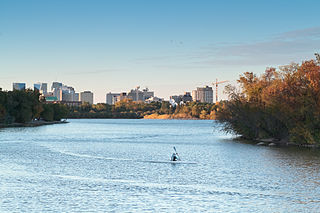
Lady Bird Lake is a river-like reservoir on the Colorado River in Austin, Texas, United States. The City of Austin created the reservoir in 1960 as a cooling pond for a new city power plant. The lake, which has a surface area of 416 acres (168 ha), is now used primarily for recreation and flood control. The reservoir is named in honor of former First Lady of the United States Lady Bird Johnson.

Amherstburg is a town near the mouth of the Detroit River in Essex County, Ontario, Canada. In 1796, Fort Malden was established here, stimulating growth in the settlement. The fort has been designated as a National Historic Site.

Cobourg is a town in the Canadian province of Ontario, located in Southern Ontario 95 km (59 mi) east of Toronto and 62 km (39 mi) east of Oshawa. It is the largest town in and seat of Northumberland County. Its nearest neighbour is Port Hope, 7 km (4 mi) to the west. It is located along Highway 401 and the former Highway 2. To the south, Cobourg borders Lake Ontario. To the north, east and west, it is surrounded by Hamilton Township.
The St. Clair River is a 40.5-mile-long (65.2 km) river in central North America which flows from Lake Huron into Lake St. Clair, forming part of the international boundary between Canada and the United States and between the Canadian province of Ontario and the U.S. state of Michigan. The river is a significant component in the Great Lakes Waterway, whose shipping channels permit cargo vessels to travel between the upper and lower Great Lakes.

Lake Merritt is a large tidal lagoon in the center of Oakland, California, just east of Downtown. It is surrounded by parkland and city neighborhoods. It is historically significant as the United States' first official wildlife refuge, designated in 1870, and has been listed as a National Historic Landmark since 1963, and on the National Register of Historic Places since 1966.

Toronto Harbour or Toronto Bay is a bay on the north shore of Lake Ontario, in Toronto, Ontario, Canada. It is a natural harbour, protected from Lake Ontario waves by the Toronto Islands. Today, the harbour is used primarily for recreational boating, including personal vessels and pleasure boats providing scenic or party cruises. Ferries travel from docks on the mainland to the Islands, and cargo ships deliver aggregates and raw sugar to industries located in the harbour. Historically, the harbour has been used for military vessels, passenger traffic and cargo traffic. Waterfront uses include residential, recreational, cultural, commercial and industrial sites.
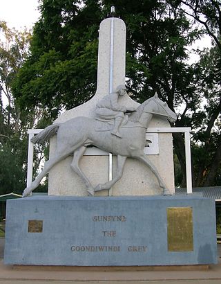
Goondiwindi is a rural town and locality in the Goondiwindi Region, Queensland, Australia. It is on the border of Queensland and New South Wales. In the 2016 census, Goondiwindi had a population of 6,355 people.

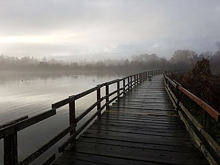
Stewart Park is a municipal park operated by the City of Ithaca, New York on the southern end of Cayuga Lake, the largest of New York's Finger Lakes.
Chandwa, is a community development block in Latehar district, in Indian state of Jharkhand. It is located around 75 km from Ranchi, the state capital. As well as its natural environment, it is known for its bauxite and coal mines. It is mineral rich like most of Jharkhand State. It lies at the junction for the NH39 and NH99 roads, and is also an important railway junction.

Interstate Park comprises two adjacent state parks on the Minnesota–Wisconsin border, both named Interstate State Park. They straddle the Dalles of the St. Croix River, a deep basalt gorge with glacial potholes and other rock formations. The Wisconsin park is 1,330 acres (538 ha) and the Minnesota park is 298 acres (121 ha). The towns of Taylors Falls, Minnesota and St. Croix Falls, Wisconsin are adjacent to the park. Interstate Park is within the Saint Croix National Scenic Riverway and the Ice Age National Scientific Reserve. The western terminus of the Ice Age National Scenic Trail is on the Wisconsin side. On the Minnesota side, two areas contain National Park Service rustic style buildings and structures that are listed on the National Register of Historic Places.
Ruskin is a rural, naturally-treed community, about 35 mi (56 km) east of Vancouver on the north shore of the Fraser River. It was named around 1900 after of the English art critic, essayist, and prominent social thinker John Ruskin.

Tintinara is a town located in the Murray and Mallee region of the South East of South Australia.
Ashford Green Corridor is a green space that runs through the town of Ashford in Kent, England. The Green Corridor is made up of parks, recreation grounds and other green spaces alongside the rivers that flow through Ashford. It is a Local Nature Reserve.
Swan Lake Christmas Hill Nature Sanctuary is a nature reserve located in Saanich, British Columbia. The sanctuary includes a lake, adjacent marshy lowlands, and the Nature House, as well as a good part of the summit regions of Christmas Hill.
Wascana Centre is a 930-hectare urban park built around Wascana Lake in Regina, Saskatchewan, Canada, established in 1912 with a design from renowned architect Thomas Mawson. The park is designed around the Saskatchewan Legislative Building and Wascana Lake. High-profile features include the University of Regina, Royal Saskatchewan Museum, Conexus Arts Centre, Saskatchewan Science Centre, and CBC Regional Broadcast Centre. Wascana Centre brings together lands and buildings owned by the City of Regina, University of Regina, and Province of Saskatchewan. The park is located immediately south of the city's downtown core, bordered by residential areas on the east, south and west, and on the south-east edge it spills out onto open Saskatchewan prairie along Wascana Creek.
The Moss Valley is an area and country park in Wrexham County Borough, Wales. The area, informally known as "The Moss" and The Aggey by local people, has an extensive coal mining history.

Duranillin is a small town located in the Wheatbelt region of Western Australia, 24 kilometres (15 mi) south of Darkan near the junction of the Arthur and Beaufort rivers.

Ashington is a town and civil parish in Northumberland, England, with a population of 27,864 at the 2011 Census. It was once a centre of the coal mining industry. The town is 15 miles (24 km) north of Newcastle upon Tyne, west of the A189 and bordered to the south by the River Wansbeck. The North Sea coast at Newbiggin-by-the-Sea is 3 miles (5 km) away.

The Lakes in Copenhagen, Denmark is a row of three rectangular lakes curving around the western margin of the City Centre, forming one of the oldest and most distinctive features of the city's topography. The paths around them are popular with strollers, bikers and runners.