
The Sierra Nevada is a mountain range in the Western United States, between the Central Valley of California and the Great Basin. The vast majority of the range lies in the state of California, although the Carson Range spur lies primarily in Nevada. The Sierra Nevada is part of the American Cordillera, an almost continuous chain of mountain ranges that forms the western "backbone" of the Americas.

The John Muir Trail (JMT) is a long-distance trail in the Sierra Nevada mountain range of California, passing through Yosemite, Kings Canyon and Sequoia National Parks. From the northern terminus at Happy Isles in Yosemite Valley and the southern terminus located on the summit of Mount Whitney, the Trail's length is 213.7 miles (343.9 km), with an elevation change of approximately 47,000 feet (14,000 m). For almost all of its length, the trail is in the High Sierra backcountry and wilderness areas. For about 160 miles (260 km), the trail follows the same footpath as the longer Pacific Crest Trail. It is named after John Muir, a naturalist.

John Muir also known as "John of the Mountains" and "Father of the National Parks", was an influential Scottish-American naturalist, author, environmental philosopher, botanist, zoologist, glaciologist, and early advocate for the preservation of wilderness in the United States of America.

The Ansel Adams Wilderness is a wilderness area in the Sierra Nevada of California, USA. The wilderness spans 231,533 acres (93,698 ha): 33.9% of which is in the Inyo National Forest, 65.8% is in the Sierra National Forest, and the remaining 0.3% covers nearly all of Devils Postpile National Monument. Yosemite National Park lies to the north and northwest, while the John Muir Wilderness lies to the south.

Mount Whitney is the tallest mountain in the contiguous United States and the Sierra Nevada, with an elevation of 14,505 feet (4,421 m). It is located in East–Central California, on the boundary between California's Inyo and Tulare counties, 84.6 miles (136.2 km) west-northwest of the lowest point in North America at Badwater Basin in Death Valley National Park at 282 ft (86 m) below sea level. The west slope of the mountain is in Sequoia National Park and the summit is the southern terminus of the John Muir Trail which runs 211.9 mi (341.0 km) from Happy Isles in Yosemite Valley. The east slope is in the Inyo National Forest in Inyo County.

The John Muir Wilderness is a wilderness area that extends along the crest of the Sierra Nevada of California for 90 miles (140 km), in the Inyo and Sierra National Forests. Established in 1964 by the Wilderness Act and named for naturalist John Muir, it contains 581,000 acres (2,350 km2). The wilderness lies along the eastern escarpment of the Sierra from near Mammoth Lakes and Devils Postpile National Monument in the north, to Cottonwood Pass near Mount Whitney in the south. The wilderness area also spans the Sierra crest north of Kings Canyon National Park, and extends on the west side of the park down to the Monarch Wilderness.

Mount Baxter is a peak along the crest of the Sierra Nevada in California. Mount Baxter is on the boundary between Kings Canyon National Park and the John Muir Wilderness just north of Baxter Pass and to the northeast of the Rae Lakes, a popular backpacking destination along the John Muir Trail.
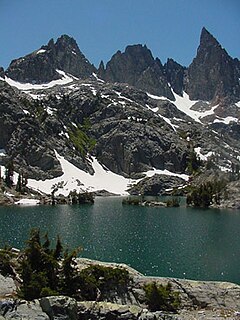
The Minarets are a series of jagged peaks located in the Ritter Range, a sub-range of the Sierra Nevada Mountains in the state of California. They are easily viewed from Minaret Summit, which is accessible by auto. Collectively, they form an arête, and are a prominent feature in the Ansel Adams Wilderness which was known as the Minaret Wilderness until it was renamed in honor of Ansel Adams in 1984.
The following is a bibliography of the Sierra Nevada of California, United States, including books on recreation, natural history, and human history.

Mount Tamalpais State Park is a California state park, located in Marin County, California. The primary feature of the park is the 2,571 feet (784 m) Mount Tamalpais. The park contains mostly redwood and oak forests. The mountain itself covers around 25,000 acres (100 km2). There are about 60 miles (97 km) of hiking trails, which are connected to a larger, 200 miles (320 km) network of trails in neighboring public lands. The park received 564,000 visitors in as of 2003. Muir Woods National Monument is surrounded by the state park.

Mount Muir is a peak in the Sierra Nevada of California, 0.95 miles (1.5 km) south of Mount Whitney. This 14,018-foot (4,273 m) peak is named in honor of Scottish-born John Muir, a famous geologist, conservationist and founder of the Sierra Club. The southernmost section of the John Muir Trail contours along the west side of Mount Muir near its summit and ends on the summit of Mount Whitney.

The High Sierra Trail (HST) is a hiking trail in Sequoia National Park, California. The trail crosses the Sierra Nevada from west to east. According to the Yosemite Decimal System, the HST is a Class 1/Class 2 trail, which means simple scrambling, with the possibility of occasional use of the hands for balance.
Thousand Island Lake is a large alpine lake in the Sierra Nevada, within the Ansel Adams Wilderness in eastern Madera County, California.
The Sierra High Route is a cross-country hiking route, 195 miles (314 km) long, through the Sierra Nevada. It was scouted by Steve Roper and described by him in his book Sierra High Route: Traversing Timberline Country.
The Sierra Crest is a roughly 500 mi (800 km) generally north-to-south ridgeline that demarcates the broad west and narrow east slopes of the Sierra Nevada (U.S.) and that extends as far east as the Sierra's topographic front. The northern and central Sierra Crest sections coincide with over 300 mi (480 km) of the Great Basin Divide, and the southern crest demarcates Tulare and Inyo counties and extends through Kern County to meet the Tehachapi crest. The Sierra Crest also forms two paths (bifurcates) around endorheic cirques between the west and east Sierra slopes.

Muir Pass is a mountain pass in the Sierra Nevada of California, United States, in Kings Canyon National Park. It is named for John Muir.

Mount Clarence King, located in the Kings Canyon National Park, is named for Clarence King, who worked on the Whitney Survey, the first geological survey of California. King later became the first chief of the United States Geological Survey.

Squaw Lake is a small lake in the eastern Sierra Nevada, near the John Muir Trail in John Muir Wilderness. It is located 1.8 miles (2.9 km) west-northwest of Mount Izack Walton and 5 miles (8.0 km) north-northeast of Lake Thomas A Edison. at an altitude of 10,315 feet (3,144 m). The outflow of Squaw Lake becomes Fish Creek, which eventually joins the Middle Fork of the San Joaquin River. The name is controversial because squaw is an ethnic and sexual slur, historically used for indigenous North American women.

Donohue Pass is a high mountain pass on the boundary between Yosemite National Park and the Ansel Adams Wilderness. Its elevation is 11,066 feet (3,373 m). It is situated between Mount Lyell and Donohue Peak. The John Muir Trail and the Pacific Crest Trail both transverse the pass. Following the John Muir Trail, the pass is 6.3 miles (10.1 km) from Thousand Island Lake, and 12.8 miles (20.6 km) from Tuolumne Meadows. Donohue Pass is the sixth highest pass of the ten named passes on the John Muir Trail.

Mount Gabb is in the central Sierra Nevada in the U.S. state of California. Mount Gabb is in the John Muir Wilderness of Sierra National Forest and is named after William More Gabb, a paleontologist and member of the Whitney Survey.


