Moroto District is a district in the Northern Region of Uganda. The town of Moroto is the site of the district headquarters.
Taveta is a town in the Taita-Taveta County, Kenya.

Mpeketoni is a town in Lamu County, on the Kenyan coast. It is a settlement scheme started in 1960s by the first president of the Republic of Kenya, Jomo Kenyatta near a fresh water lake bearing his name.
Manda Airport, also called Lamu Airport, is an airport in Kenya.
El Wak, also Elwak is a town in Kenya, on the International border with Somalia.
Garsen is a small town located in Tana River County, Kenya. It is on the west bank of the Tana River.
Mokowe is a small town in Kenya's Lamu County in what was previously Coast Province.
Rabai Thermal Power Station is a 90 megawatt heavy fuel oil-fired thermal power station in Kilifi County, Kenya.
Rhamu is a town in the Mandera County of Kenya one of the oldest towns in North Eastern Kenya and is the second largest town of the County. It sits across the Dawa River from the town of Sathe populated by the Dagodia Somali Clan in Ethiopia. It is largely populated by the Dagodia Somali. The town was built by Dagodia tribe. Rhamu is located at the international border between Kenya and Ethiopia. The town is an agricultural town known for producing many types of fruits, vegetables, maize, sorghum etc.
Isebania, also Isibania, is a town in Tarime District, Mara Region, in northern Tanzania, at the border with Kenya.
Lafey is a town and sub-county in the Mandera County of Kenya. It sits in the northeast part of the country, at the international border with Somalia.
Makutano is a settlement in Kenya's Kirinyaga County.
Mavueni is a neighborhood in the city of Kilifi, in Kenya's Kilifi County.
The Garissa–Nuno–Modogashe–Wajir Road is a road in Kenya, connecting the towns of Garissa, Nuno, Modogashe and Wajir.
Garsen–Witu–Lamu Highway is a road, under construction in Kenya, connecting the towns of Garsen, Witu and Lamu.
Rhamu Airport is an airport in Kenya.
The Ndula Hydroelectric Power Station is a 2.0 MW (2,700 hp) hydroelectric power station on the Thika River in Kenya.

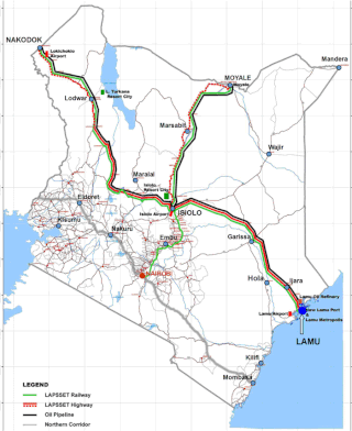
Lamu-Garissa-Isiolo Road, is a road in Kenya, and is part of the Lamu-Garissa-Isiolo-Lokichar Road, which itself is a component of the Lamu Port and Lamu-Southern Sudan-Ethiopia Transport Corridor (LAPSSET) Project.

The Isiolo–Moyale Road is a road section of the A2 Road in Kenya, connecting the towns of Isiolo, Archers Post, Marsabit, and Moyale. The road is a component of the Lamu Port and Lamu-Southern Sudan-Ethiopia Transport Corridor (LAPSSET) Project. It connects Kenya to Ethiopia, its neighbor to the north.


