Mount Ruapehu is an active stratovolcano at the southern end of the Taupō Volcanic Zone and North Island volcanic plateau in New Zealand. It is 23 km (14 mi) northeast of Ohakune and 23 km (14 mi) southwest of the southern shore of Lake Taupō, within the Tongariro National Park. The North Island's major ski resorts and only glaciers are on its slopes.

The Waikato River is the longest river in New Zealand, running for 425 kilometres (264 mi) through the North Island. It rises on the eastern slopes of Mount Ruapehu, joining the Tongariro River system and flowing through Lake Taupō, New Zealand's largest lake. It then drains Taupō at the lake's northeastern edge, creates the Huka Falls, and flows northwest through the Waikato Plains. It empties into the Tasman Sea south of Auckland, at Port Waikato. It gives its name to the Waikato region that surrounds the Waikato Plains. The present course of the river was largely formed about 17,000 years ago. Contributing factors were climate warming, forest being reestablished in the river headwaters and the deepening, rather than widening, of the existing river channel. The channel was gradually eroded as far up river as Piarere, leaving the old Hinuera channel through the Hinuera Gap high and dry. The remains of the old course are seen clearly at Hinuera, where the cliffs mark the ancient river edges. The Waikato's main tributary is the Waipā River, which converges with it at Ngāruawāhia.

The Taupō Volcanic Zone (TVZ) is a volcanic area in the North Island of New Zealand that has been active for the past two million years and is still highly active. Mount Ruapehu marks its south-western end and the zone runs north-eastward through the Taupō and Rotorua areas and offshore into the Bay of Plenty. It is part of the larger Central Volcanic Region that extends further westward through the western Bay of Plenty to the eastern side of the Coromandel Peninsula and has been active for four million years. At Taupō the rift volcanic zone is widening east–west at the rate of about 8 mm per year while at Mount Ruapehu it is only 2–4 mm per year but this increases at the north eastern end at the Bay of Plenty coast to 10–15 mm per year. It is named after Lake Taupō, the flooded caldera of the largest volcano in the zone, the Taupō Volcano and contains a large central volcanic plateau as well as other landforms associated with its containing tectonic intra-arc continental Taupō Rift.

Mount Taranaki is a dormant stratovolcano in the Taranaki region on the west coast of New Zealand's North Island. At 2,518 metres (8,261 ft), it is the second highest mountain in the North Island, after Mount Ruapehu. It has a secondary cone, Fanthams Peak, 1,966 metres (6,450 ft), on its south side.
Tongariro National Park is the oldest national park in New Zealand, located in the central North Island. It has been acknowledged by UNESCO as a World Heritage Site of mixed cultural and natural values.
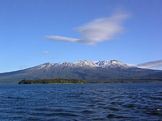
Mount Tongariro is a compound volcano in the Taupō Volcanic Zone of the North Island of New Zealand. It is located 20 km (12 mi) to the southwest of Lake Taupō, and is the northernmost of the three active volcanoes that dominate the landscape of the central North Island.

Ohakune is a small town at the southern end of Tongariro National Park, close to the southwestern slopes of the active volcano Mount Ruapehu, in the North Island of New Zealand.

The North Island Volcanic Plateau is a volcanic plateau covering much of central North Island of New Zealand with volcanoes, lava plateaus, and crater lakes. It contains the Taupō caldera complex, Ōkataina caldera complex and Tongariro Volcanic Centre resulting in it being currently the most frequently active and productive area of silicic volcanism on Earth. New Zealand is part of the Pacific Ring of Fire.

The Grand Chateau, also known as the Chateau Tongariro, was a hotel and resort complex located close to Whakapapa skifield on the slopes of Mount Ruapehu, within the boundaries of Tongariro National Park, New Zealand's oldest national park. It was also close to the volcanic peaks of Mount Tongariro and Mount Ngauruhoe. The building was completed in 1929 and, despite extensive refurbishment, still retains much of the style of the pre-Depression era. It is listed by Heritage New Zealand as a Category 1 historic place. The Chateau Tongariro Hotel closed permanently on 5 February 2023.

The Whangaehu River is a large river in central North Island of New Zealand. Its headwaters are the crater lake of Mount Ruapehu on the central plateau, and it flows into the Tasman Sea eight kilometres southeast of Whanganui. Water is diverted from the headwaters for the Tongariro Power Scheme.

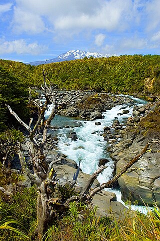
The Whakapapa River in New Zealand forms from streams which trickle off the Whakapapa skifield of Mount Ruapehu and down the western slopes of the mountain. The river passes near Ōwhango, before finally merging with the Whanganui River just east of Kakahi, about 40 km (25 mi) from where it starts, which is in a 100 m (330 ft) deep gorge, at the confluence of the Whakapapaiti and Whakapapanui Streams.
Albury is a small village in the southern part of the Canterbury region of the South Island of New Zealand. It is inland from Timaru and located on State Highway 8 between Pleasant Point and Fairlie. It is in the Mackenzie Country.

The Tongariro River is a river in the North Island of New Zealand. The part of the Waikato River from the Waihohonu Stream, down to Lake Taupo, was formally named the Tongariro River in 1945. The river originates in the Central Plateau of the North Island where it is fed by numerous tributaries that flow off the surrounding hill ranges and mountains such as Mount Ruapehu. It then winds its way north, through the township of Turangi before entering Lake Taupo via a number of river mouths. The minimum volume of water flowing down the lower Tongariro River ranges from approximately 16 cubic metres per second (570 cu ft/s) to 21 cubic metres per second (740 cu ft/s). This volume can substantially increase due to catchment of rainfall by the surrounding mountains and hill ranges.
The Tongariro Power Scheme is a 360 MW hydroelectricity scheme in the central North Island of New Zealand. The scheme is currently operated by electricity generation company Genesis Energy.
The Moawhango River is a tributary of the Rangitīkei River and is located the central North Island of New Zealand.
The Moawhango West River is a river of the Manawatū-Whanganui region in New Zealand. A tributary of the Moawhango River, it flows into the latter to the northeast of Lake Moawhango.

Whangaehu is a settlement in the Rangitikei District and Manawatū-Whanganui region of New Zealand's North Island.
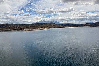
Lake Otamangakau is a small artificial lake located within Tongariro National Park in the Ruapehu District.