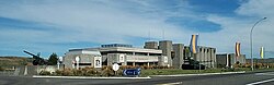
The main attraction of Waiouru is the National Army Museum, opened in 1978, which features static displays of New Zealand's military heritage. The rest of the township consists of a small cluster of a police station, two garages, a petrol station/postal agency, a panel beater, two motels, a tavern and half a dozen cafe/restaurants spread along the highway. There are three unmanned diesel refueling sites for the 700+ big freight trucks that pass through Waiouru each day. Nearby are the yards of a roading contractor and a maintenance contractor. A grocery store, hairdresser and beautician are in the Army housing area two kilometres away, and a medical centre, public library, cafe and department store are inside the army camp.
Waiouru is a military town that has grown up in conjunction with the New Zealand ArmyCamp and the Training Group (ATG), which is responsible for the training of recruits and other soldiers. The Desert Road immediately north of Waiouru runs through the 870km2 army training area, which lies mainly to the east of the road. The Royal NZ Navy's Irirangi communications station with its huge antennae is 2km north of Waiouru.
Seven kilometres to the west of Waiouru is the small settlement of Tangiwai, the site of New Zealand's worst railway disaster. On 24 December 1953 the overnight express from Wellington to Auckland passed over Tangiwai railway bridge just after it had been weakened by a lahar from Mount Ruapehu. The bridge collapsed, sending the train into the Whangaehu River, killing 151 people. Many army and naval personnel were involved in the rescue of survivors and the recovery of bodies. Sister Mortimer of the Waiouru Camp Hospital, "The Angel of Tangiwai", worked non-stop for three days tending the survivors and laying out the bodies.[4]
History
Merino sheep were brought from Taupō in 1855 by missionary Tom Grace, to graze on the tussock lands in the Waiouru area. The flock was eaten by Te Kooti's warriors in 1869, and 4000 more merinos were brought over the mountains from Hawke's Bay.
In England, the development of steam-powered machinery for making woolen cloth caused the price paid for raw wool to rise to £150 per ton, (about NZ$60 a kilo at today's values). And Waiouru sat in the middle of the Murimotu plains, 60,000 hectares of tussock grassland, enough to graze 60,000 sheep, annually producing about 240 tons of wool worth £36,000 (with the buying power of NZ$14 million today)
In 1871 the government sought to lease these tussock plains. It offered the Maori land-owners an annual rent of £3500, worth NZ$1.4 million today. But first, all the land-owning groups had to agree, and this caused great delays, as parts of the Murimotu plains had been used to gather wild-fowl by all the surrounding land-owners, Ngati Rangi (Karioi/Whanganui river) Te Ati Hau/Tūwharetoa (Taumarunui/Lake Taupō) and Ngati Whiti (Moawhango).
The boundaries had already been sorted out back in 1850 at a huge hui chaired by Wanganui missionary Richard Taylor, with most of the Murimotu land being allotted to various hapu of Ngati Rangi, but no money was at stake back then, and in the intervening 20 years the Hauhau/Titokowaru/Te Kooti wars had been fought, creating new power groups and enmities, especially between the coastal Whanganui guerilla leader Major Kemp/Te Keepa and his upper river rival, Major Topia Turoa, and consequently numerous conflicting claims were put forward.
In 1876, after five years of Land Court hearings at Wanganui, there was still no agreement. By 1877, one hundred and six claimant owners had signed the lease agreement, but the land had not been surveyed, so others still refused to sign.[5]
Studholme's land grab
While they argued, John Studholme, described by the Wanganui Herald as a "Canterbury land shark", had already been grazing the land around Waiouru for three years. Backed by the Auckland capitalists Moorhouse, Morrin and Russell, he had made a highly illegal deal in 1874, leasing the land for 21 years from Topia Turoa, who claimed ownership of all the land between Rangipo and Karioi through his marriage of Makarena Utaora of Ngati Rangi.
In March 1874, Studholme's men had moved cattle and sheep onto the land. They started building houses, stables and sheds at Karioi, and shepherds' huts at Waiouru.
In January 1880 the Studholme land ring tried to obtain permanent ownership of the land from Topia and sent surveyors to mark the exact boundaries. This incensed the Ngati Rangi faction and they called on Major Kemp for assistance. He re-activated his company of seasoned gun-fighters, with whom he had routed the Hauhau at the Battle of Moutua Island 16 years previously, and they rode up from the Whanganui river valley to Waiouru, and then on another 10km east to the strategic high ground of Auahitotara, where they began some sabre-rattling live-firing practice. This upset the Ngati Whiti people at Moawhango village 15km to the east, who re-activated their own gun-fighters as well. The Moawhango militia moved forward to two shepherds' huts at Te Waiu and dug gun-fighters' trenches all round them. These trenches, known as the Waiu Pa site, can still be seen today.
A Maori missionary defused the situation before any bloodshed occurred, and in 1884 the Land Court finally awarded ownership of each block of the now-surveyed Murimotu land to various hapu of Ngati Rangi, although Studholme's political connections in Wellington allowed him to keep his lease for its remaining 11 years.
But it was a hollow victory for Studholme; although his costs remained high, the price paid for wool plummeted as vast new sheep farms in Australia came into production. And the extremely cold winter of 1893, with deep snow on the ground from Easter to October, killed 20,000 of his sheep and left the rest emaciated.
By the mid-1890s there were only 40,000 merinos on the tussock lands between Karioi bush and the Kaimanawa Ranges.[5]
Infrastructure development
Pack-tracks had been formed in the 1870s, after traces of gold were discovered in 1869, 30km north-east of Waiouru on Mr. Lyon's run at Kereru. The Gentle Annie track was used to get the hundreds of tons of Murimotu wool to Napier and later the shorter, but muddier, routes of Hales' Track and Field's Track to Wanganui were built. These tracks were later developed into roads for wool wagons and stage-coaches. By 1897 there was a coaching house at Waiouru for mail-coach passengers on the Napier-Taupō run.
About 1904, Alfred Peters set up a post office, store and an accommodation house for travelers at Waiouru and for the 500 men who were digging the huge railway cuttings 1km west of Waiouru. (Archer 2009) In 2007, Alfred Peters' descendants were still farming just east of Waiouru 100 years later.
By 1907 little wool was being sent out, as overgrazing by sheep had led to a plague of rabbits. By the 1930s no sheep at all could be grazed on the Waiouru sheep station. In 1939 most of the leasehold Waiouru sheep station land was taken by the Government for the Army Camp.
Wally Harding began farming and developing the Waiouru sheep station in 1939, cultivating the tussock land with giant discs pulled by a crawler tractor, and then oversowing with swedes. In 1951 he began aerial topdressing his farm with a war-surplus Tiger Moth. (Moss 1956) This project expanded into Wanganui Aero Work Ltd. Wallie's grandson Lockie still farms at Waiouru in 2014.
In 1978, the QEII Army Memorial Museum, now named the National Army Museum, was opened. Its buildings were designed by Sir Miles Warren and it was built alongside State Highway 1 by engineers of the New Zealand Army. It has since been expanded with additions constructed in 1983 and 1995.[6]
Demographics
Waiouru covers 5.01km2 (1.93sqmi)[1] and had an estimated population of 770 as of June 2022,[2] with a population density of 154 people per km2.
Waiouru had a population of 765 at the 2018 New Zealand census, an increase of 24 people (3.2%) since the 2013 census, and a decrease of 597 people (−43.8%) since the 2006 census. There were 219 households, comprising 438 males and 327 females, giving a sex ratio of 1.34 males per female. The median age was 28.0 years (compared with 37.4 years nationally), with 198 people (25.9%) aged under 15 years, 222 (29.0%) aged 15 to 29, 306 (40.0%) aged 30 to 64, and 39 (5.1%) aged 65 or older.
Ethnicities were 67.8% European/Pākehā, 41.2% Māori, 6.3% Pacific peoples, 4.7% Asian, and 3.5% other ethnicities. People may identify with more than one ethnicity.
The percentage of people born overseas was 12.9, compared with 27.1% nationally.
Although some people chose not to answer the census's question about religious affiliation, 51.4% had no religion, 31.4% were Christian, 5.1% had Māori religious beliefs, 0.4% were Hindu, 0.4% were Buddhist and 2.7% had other religions.
Of those at least 15 years old, 81 (14.3%) people had a bachelor's or higher degree, and 96 (16.9%) people had no formal qualifications. The median income was $44,900, compared with $31,800 nationally. 93 people (16.4%) earned over $70,000 compared to 17.2% nationally. The employment status of those at least 15 was that 423 (74.6%) people were employed full-time, 60 (10.6%) were part-time, and 12 (2.1%) were unemployed.[3]
From 1936 to 1938, Territorial artillery batteries camped under canvas at Waiouru for their summer training exercises. In 1939, a month after war was declared, most of the leasehold Waiouru run was taken back by the Crown. By December 1940 a large training camp had been built, and 340km2 of land acquired for training.[7]
From 1949 another 250km2 of land to the north and east was acquired for training, and for upgrading of the State Highway and constructing a high-voltage power line up the Moawhango valley. The base expanded for compulsory National Service and for NZSAS training. At its peak in the 1970s, Waiouru had a population of 6000 people, including 600+ school aged children.[8]
In the 1980s, some army units were transferred to Linton, and by 1990 Waiouru's permanent population had fallen to about 3000. In 2005, Waiouru's population dropped to about 2000 with the transfer out of armoured force personnel, and continues to drop as operations are shifted to nearby Linton Camp and Ohakea. But the Army expects a number of courses to continue to be run at Waiouru.
This Radio Intercept Station 2km south of Waiouru was run by the Royal New Zealand Navy during WWII as Waiouru W/T Station, and from 1951 as HMNZS Irirangi. (Waters 1956) It has now been replaced as an Intercept Station.
Climate
Because of its high altitude and close proximity to Mt Ruapehu, Waiouru's climate is cold throughout the year, unlike other North Island centres, and particularly cold when the wind blows from the mountain. The Desert Road is regularly closed in winter owing to heavy snowfalls. Waiouru's climate can be described as continental.[citation needed]However according to the Köppen Climate Classification, the climate is an oceanic climate (cfb)
The Tangiwai disaster occurred at 10:21 p.m. on 24 December 1953 when a railway bridge over the Whangaehu River collapsed beneath an express passenger train at Tangiwai, North Island, New Zealand. The locomotive and the first six carriages derailed into the river, killing 151 people. The subsequent board of inquiry found that the accident was caused by the collapse of the tephra dam holding back nearby Mount Ruapehu's crater lake, creating a rapid mudflow (lahar) in the Whangaehu River, which destroyed one of the bridge piers at Tangiwai only minutes before the train reached the bridge. The volcano itself was not erupting at the time. The disaster remains New Zealand's worst rail accident.
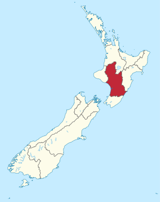
Manawatū-Whanganui is a region in the lower half of the North Island of New Zealand, whose main population centres are the cities of Palmerston North and Whanganui. It is administered by the Manawatū-Whanganui Regional Council, which operates under the name Horizons Regional Council.
Tangiwai is a 2,696.63 km2 (1,041.17 sq mi) census area and a small rural community in the Ruapehu District of the Manawatū-Whanganui region of New Zealand's North Island. It is located east of Ohakune and Rangataua and west of Waiouru on State Highway 49. In 2018 37.5% of the area's 1,281 residents worked in agriculture, forestry and fishing and 7.1% in manufacturing.
Taumarunui is a small town in the King Country of the central North Island of New Zealand. It is on an alluvial plain set within rugged terrain on the upper reaches of the Whanganui River, 65 km south of Te Kuiti and 55 km west of Turangi. It is under the jurisdiction of Ruapehu District and Manawatū-Whanganui region.
Tongariro National Park is the oldest national park in New Zealand, located in the central North Island. It has been acknowledged by UNESCO as a World Heritage Site of mixed cultural and natural values.
Ohakune is a small town at the southern end of Tongariro National Park, close to the southwestern slopes of the active volcano Mount Ruapehu, in the North Island of New Zealand.
The North Island Volcanic Plateau is a volcanic plateau covering much of central North Island of New Zealand with volcanoes, lava plateaus, and crater lakes. It contains the Taupō caldera complex, Ōkataina caldera complex and Tongariro Volcanic Centre resulting in it being currently the most frequently active and productive area of silicic volcanism on Earth. New Zealand is part of the Pacific Ring of Fire.
Te Onetapu, commonly known as the Rangipo Desert, is a barren desert-like environment in New Zealand, located in the Ruapehu District on the North Island Volcanic Plateau; to the east of the three active peaks of Mount Tongariro, Mount Ngauruhoe, and Mount Ruapehu, and to the west of the Kaimanawa Range.
Raetihi, a small town in the centre of New Zealand's North Island, is located at the junction of State Highways 4 and 49 in the Manawatū-Whanganui region. It lies in a valley between Tongariro and Whanganui National Parks, 11 kilometres west of Ohakune's ski fields.
The Whanganui River is a major river in the North Island of New Zealand. It is the country's third-longest river, and has special status owing to its importance to the region's Māori people. In March 2017 it became the world's second natural resource to be given its own legal identity, with the rights, duties and liabilities of a legal person. The Whanganui Treaty settlement brought the longest-running litigation in New Zealand history to an end.
In Māori tradition, Ngātoro-i-rangi (Ngātoro) is the name of a tohunga (priest) prominent during the settling of New Zealand (Aotearoa) by the Māori people, who came from the traditional homeland Hawaiki on the Arawa canoe. He is the ancestor of Ngāti Tūwharetoa and his travels around Lake Taupō and up onto the Volcanic Plateau are the basis of Ngāti Tūwharetoa's claim to those regions.
Mangamahu is a hill-country farming and forestry community in the middle reaches of the Whangaehu River valley, in the Whanganui District and Rangitikei District of Manawatū-Whanganui, New Zealand. It is centred on the village of Mangamahu, which is situated on river flats where the Mangamahu stream flows into the Whangaehu river. Mangamahu has a primary school which has been open since 1894 and a War Memorial hall built in 1952.
Waiouru Military Camp is a camp of the New Zealand Army in the central North Island of New Zealand near Waiouru.
Ngāti Hauiti is a Māori iwi of New Zealand. It is centred in the Rangitikei area of the lower North Island.
Whanganui Māori are the Māori iwi (tribes) and hapū (sub-tribes) of the Whanganui River area of New Zealand. They are also known as Ngāti Hau.
Ngāti Rangi or Ngāti Rangituhia is a Māori iwi (tribe) of New Zealand. Contemporary settlement is mainly around Waiouru, Ohakune, and the Upper Whanganui River in the central North Island. The iwi's area of interest extends north from the Paretetaitonga peak of Mount Ruapehu, west to the Pukupuku Stream, east to the meeting of the Moawhango and Aorangi waterways, and south to the Haumakariri Stream. Ngāti Rangi trace their ancestry to Paerangi. They believe they were in New Zealand before the first migrations from Hawaiki.
Te Whakaruruhau o Ngā Reo Irirangi Māori is a New Zealand radio network consisting of radio stations that serve the country's indigenous Māori population. Most stations receive contestable government funding from Te Māngai Pāho, the Māori Broadcast Funding Agency, to operate on behalf of affiliated iwi (tribes) or hapū (sub-tribes). Under their funding agreement, the stations must produce programmes in the Māori language, and must actively promote Māori culture.
Karioi was a station on the North Island Main Trunk line, in the Ruapehu District of New Zealand. A passing loop remains.
Erua was a station on the North Island Main Trunk line, in the Ruapehu District of New Zealand. It served the small village of Erua. For a month in 1908 it was the terminus of the line from Auckland. Makatote Viaduct and tramway are about 3 mi (4.8 km) south of Erua.
The seismically active southern end of the Taupō Rift beyond Mount Ruapehu has a number of mainly east to west orientated termination faults where the western wall Raurimu Fault and eastern wall Rangipo Fault terminate in the Ruapehu Graben, of the central North Island of New Zealand. In a multi-fault rupture event there is the potential for the earthquake being of Mw7.1 magnitude.
References
Archer, J.H. 2009, The Murimotu Time Travellers Club, articles in the Waiouru Tussock, condensed from contemporary newspaper items found on the PapersPast website.
Arthur, P.M. 1984, Waiouru, Land of the Tussock, 1935–40.
Croom, F.G. 1941, The History of the Waiouru Military Camp.
Gregory, A. Weekend Herald 24 Dec 2003
Moss, G.R. 1956, The Waiouru Tussock Lands, NZ Jnl of Ag, 16 July 1956.
Newspaper cutting, 1991, - author and journal unknown.
NZ Army Brief - Waiouru Land Acquisition, 1987 - authors unknown.
This page is based on this Wikipedia article Text is available under the CC BY-SA 4.0 license; additional terms may apply. Images, videos and audio are available under their respective licenses.