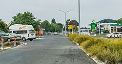
Tūrangi is a small town on the west bank of the Tongariro River, 50 kilometres south-west of Taupō on the North Island Volcanic Plateau of New Zealand. It was built to accommodate the workers associated with the Tongariro hydro-electric power development project and their families. The town was designed to remain as a small servicing centre for the exotic forest plantations south of Lake Taupō and for tourists. It is well known for its trout fishing and calls itself "The trout fishing capital of the world". The major Māorihapū (tribe) of the Tūrangi area is Ngāti Tūrangitukua.
The Tūrangi area covers some 2273km², and is located close to the edge of the Kaimanawa Ranges and ten kilometres north of the stretch of State Highway 1 known as the Desert Road.
The streets around Tūrangi in autumn are lined with "brilliant" foliage.[3]
Built on the banks of the Tongariro River, Tūrangi and its surrounding countryside offers challenging hunting, fishing, mountain biking, hiking or leisurely bush walks, white water rafting, kayaking and sight seeing.[4]
Population and demographics
Tūrangi covers 7.53km2 (2.91sqmi)[1] and had an estimated population of 3,840 as of June 2023,[5] with a population density of 510 people per km2. It is the second largest population centre in the Taupō District after Taupō. Tūrangi's population peaked at 9,000 during the 1970s. After the end of the Project in the 1980s the population declined but has since remained stable due to the town's handy location for tourists.
Tūrangi had a population of 3,444 at the 2018 New Zealand census, an increase of 492 people (16.7%) since the 2013 census, and an increase of 204 people (6.3%) since the 2006 census. There were 1,224 households, comprising 1,713 males and 1,728 females, giving a sex ratio of 0.99 males per female. The median age was 40.0 years (compared with 37.4 years nationally), with 795 people (23.1%) aged under 15 years, 546 (15.9%) aged 15 to 29, 1,413 (41.0%) aged 30 to 64, and 693 (20.1%) aged 65 or older.
Ethnicities were 51.6% European/Pākehā, 62.8% Māori, 4.4% Pacific peoples, 2.9% Asian, and 1.4% other ethnicities. People may identify with more than one ethnicity.
The percentage of people born overseas was 10.7, compared with 27.1% nationally.
Although some people chose not to answer the census's question about religious affiliation, 41.1% had no religion, 29.2% were Christian, 19.4% had Māori religious beliefs, 0.3% were Hindu, 0.1% were Muslim, 0.6% were Buddhist and 1.9% had other religions.
Of those at least 15 years old, 279 (10.5%) people had a bachelor's or higher degree, and 642 (24.2%) people had no formal qualifications. The median income was $22,900, compared with $31,800 nationally. 189 people (7.1%) earned over $70,000 compared to 17.2% nationally. The employment status of those at least 15 was that 1,041 (39.3%) people were employed full-time, 444 (16.8%) were part-time, and 177 (6.7%) were unemployed.[6]
Economy
Tourism and forestry are the mainstay of the community with the Department of Corrections two prisons, Genesis Energy, the Department of Conservation and farming being the main employers. The town is also home to a Centre for Sustainable Practice at Awhi Farm, providing education and enterprise training.
History
Māori settlement
The area was settled by the people of Ngāti Tūwharetoa, descendants of those who had originally settled in the Kawerau area. The Ngāti Tūwharetoa invasion of Taupō occurred from about the 16th century with a war party under command of Tūrangitukua who engaged in a number of battles against earlier inhabitants of the Taupō, Rotoaira and Kaimanawa area.[7] Following these battles a variety of settlements were established in the area with major pa established on the cliff overlooking the Tongariro River and at Waitahanui on the Tongariro Delta. Another important settlement was at Tokaanu.
The people who eventually become known as Ngāti Tūrangitukua associate mainly with Waitahanui pā. From here they established a number of homesteads along both sides of the Tongariro River and its tributaries, including houses along the main Highway to Taumarunui (now Hirangi Road). In 1910 construction of a wharepuni begun which eventually became the Hirangi Marae complex.[8]
Tongariro River
Non-Māori settlement
The first Europeans reached the Tūrangi area in the 1830s,[9] however it was not until the 1850s that European settlement occurred with the construction of a Mission Station at Pukawa.
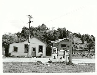
In the 1880s and 1890s brown and rainbow trout were introduced into the lake and rivers of the area. A small fishing camp was established at Taupahi on the Tongariro River bank (now Taupahi Road). European settlers used the camp for recreational fishing.
In the 1920s two prison farms were opened at Rangipo and Hautu[9] because of the isolated nature of the area. Also during this period the Morar family arrived from India, settling and establishing a store in Tokaanu.
In the 1950s, in response to post World War II needs for rapid expansion of energy resources to meet the growing industrialisation in New Zealand, the Tongariro Power Scheme proposal was developed. The scheme would require a large construction force, and provide accommodation for that force for the duration of the project.
Four sites were considered for the township to accommodate the project workers: Rotoaira, Rangipo, Tūrangi West, and Tūrangi East. The tourism potential of Lake Taupō was appreciated, as well as the economic benefits that could be captured by creating a permanent township. Taking into account accessibility, climate, and adequacy of suitable land for development of a township, it was decided proceed with the Turangi West site.
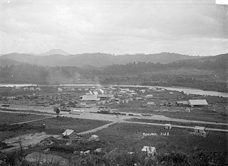
Construction of the modern town began late in 1964.[9] The Government invested $16 million [9] in the development and by May 1966, the population of Tūrangi had jumped from 500 to 2,500[9] people. By 1968 the population reached a high of 6,500.[9] A model town with curving streets and cul-de-sacs, uniform houses, pedestrian shopping centre, car parks and separation from the traffic on the main highway was created.[9]
A publicity pamphlet published by the Ministry of Works in 1969 described Tūrangi at that time as a pleasant and attractive town of 5000 people which offered a ‘balanced community life’. The pamphlet enumerated the town's amenities, shops, and services, such as its mall, schools, sports facilities, library, maternity hospital, parks, and, not least, its wide, grassy verges and kerbing.[10]
Following the completion of the project in the late 1970s,[9] the Ministry of Works and other government departments began a process of selling assets[9] within the Turangi township.
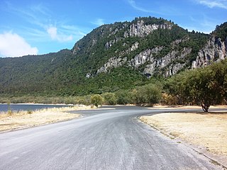
Eastern Lake Taupō, Tūrangi to Taupō
Treaty settlement
In 1989 Ngāti Tūrangitukua registered with the Waitangi Tribunal (Wai 84). The claim was heard under urgency between April and October 1994, and the Tribunal's Report was released in September 1995.
The Tribunal found that the Crown had breached the principles of the Treaty of Waitangi in a number of ways:
The Crown acquired Māori land at Tūrangi West when Crown land at Tūrangi East was available:
The Crown did not adequately consult with Ngāti Tūrangitukua regarding the construction of the township:
The land taken for the township was in excess of the maximum area that the Crown promised it would take:
The land the Crown undertook to lease for industrial purposes and return to the people after 10 to 12 years was compulsorily acquired and not returned:
Wahi tapu were destroyed or damaged in the construction of the township:
Adequate compensation was not paid for land acquired:
The Crown did not give full effect to conservation values:
The Crown did not pay Ngāti Tūrangitukua the respect due its mana as tangata whenua:
The provisions of the Public Works Act 1928 and the Tūrangi Township Act 1964, relied on by the Crown in entering and taking the claimants' land, are inconsistent with the basic guarantee in Article II of the Treaty of Waitangi that Māori may keep their land until such time as they wish to sell it.
The Tribunal found that, as a result of the Crown's breaches of the principles of the Treaty, Ngāti Tūrangitukua lost much of its ancestral land. Its social and economic base was seriously eroded causing spiritual, cultural, and economic prejudice to Ngāti Tūrangitukua.
In July 1998,[11] the Crown and Ngāti Tūrangitukua negotiated to achieve a full and final settlement of Ngāti Tūrangitukua's Treaty claims and to remove the continuing sense of grievance.
The Crown and Ngāti Tūrangitukua entered into a deed of settlement on 26 September 1998,[12] resulting in a full and final settlement of Ngāti Tūrangitukua's Treaty claims relating to the development and construction of the Tūrangi Township and its after effects.
(a) To record the apology given by the Crown to Ngāti Tūrangitukua in the deed of settlement executed on 26 September 1998 by the Minister in Charge of Treaty of Waitangi Negotiations, the Right Honourable Sir Douglas Arthur Montrose Graham, for the Crown, and Ngāti Tūrangitukua; and
(b) To give effect to certain provisions of that deed of settlement, being a deed that settles the Ngāti Tūrangitukua claims.
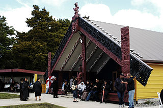
Korohē Marae Rereao meeting house, located further east, is a meeting place of the Ngāti Tūwharetoa hapū of Ngāti Hine.[14][15] In October 2020, the Government committed $1,338,668 from the Provincial Growth Fund to upgrade the marae and 4 other Ngāti Tūwharetoa marae, creating 19 jobs.[16]
Tūrangi is located in the administrative areas of the Taupō District Council and three of the council's eleven representatives are elected directly from a Tūrangi Tongariro ward.[17] Tūrangi is administered[17] by the Turangi/Tongariro Community Board under delegated powers from the Taupō District Council. This ensures that all locally important decisions are made by local residents.
The role of the Tūrangi Tongariro Community Boards is to:[17]
Represent and act as an advocate for, the interests of its communities.
Consider and report on all matters referred to it by Council, or any matter of interest to the community board.
Maintain an overview of services provided by Council within the community.
Prepare an annual submission to Council on expenditure within the community.
Communicate with community organisations and special interest groups within the community.
The Taupō District is itself part of the Waikato region, controlled administratively by the Environment Waikato.
There are three schools in the Tūrangi area. Within the Tūrangi township are two schools, both area schools which cater for Year 1 to 13 students. The schools opened in February 2004, following the Tūrangi Education Network Review that resulted in the closure[18] of four schools: Hirangi Primary, Turangi Primary, Tongariro High and Tauranga-Taupo Primary Schools were closed. Previously Pihanga Primary existed, but was closed in the mid 1980s.
A single Year 1 – 15 composite state area school, Tongariro School, was established in their place.[19][20] with a roll of 359 as of April 2023.[21][22]
A Kura Kaupapa Māori for Year 1 – 13 students, Te Kura o Hirangi, was established for those who wish to receive their education in te reo Māori.[23] with a roll of 263.[24]
There is also a rural school at Kuratau, approximately 30km west of Tūrangi on SH 41 to Taumarunui.
Taumarunui is a small town in the King Country of the central North Island of New Zealand. It is on an alluvial plain set within rugged terrain on the upper reaches of the Whanganui River, 65 km south of Te Kuiti and 55 km west of Turangi. It is under the jurisdiction of Ruapehu District and Manawatū-Whanganui region.
Matakana Island is located in the western Bay of Plenty in New Zealand's North Island. A long, flat barrier island, it is 20 kilometres (12 mi) in length but rarely more than 3 kilometres (1.9 mi) wide. The island has been continuously populated for centuries by Māori tribes that are mostly associated with Ngāi Te Rangi.
Murupara is a town in the Whakatāne District and Bay of Plenty Region of New Zealand's North Island. The town is in an isolated part of the region between the Kaingaroa Forest and Te Urewera protected area, on the banks of the Rangitaiki River, 65 kilometres southeast of Rotorua. Indigenous Māori also make up over 90% of the population.
Kakahi ) is a small King Country settlement about 10 kilometres (6.2 mi) up the Whanganui River from Taumarunui, New Zealand. Founded as a sawmill town, it takes its name from the Māori word for the New Zealand freshwater mussel.
Taupō District Council is a territorial authority that administers the Taupō District in the Central North Island of New Zealand. The district stretches from the small town of Mangakino in the northwest to the Tongariro National Park in the south, and east into the Kaingaroa Forest, covering 6,970 km2. It had a population of as of June 2023.
Ngāti Tūwharetoa is an iwi descended from Ngātoro-i-rangi, the priest who navigated the Arawa canoe to New Zealand. The Tūwharetoa region extends from Te Awa o te Atua at Matatā across the central plateau of the North Island to the lands around Mount Tongariro and Lake Taupō.
Pukawa or Pukawa Bay is a bay and a small township on the southern shores of Lake Taupō on New Zealand's North Island. It is off State Highway 41 between Turangi and Taumarunui, in the Taupō District and Waikato region.
Manunui is a small Whanganui River settlement, about 6 kilometres (3.7 mi) east of Taumarunui on State Highway 4, in New Zealand's King Country. It was once known as Waimarino, but John Burnand of the Ellis and Burnand sawmilling firm renamed it Manunui around 1905.
Nukuhau is a suburb of Taupō in the Waikato Region of New Zealand's North Island.
Kuratau is a small village north of Pukawa, on the western side of New Zealand's Lake Taupō.
Ngāti Tūrangitukua is a Māori iwi (tribe) in Tūrangi, New Zealand. It is a hapu (sub-tribe) of the Ngāti Tūwharetoa iwi.
Tokaanu is a small settlement close to Tūrangi at the southern end of Lake Taupō.
Mokai is a rural community in the Taupo District and Waikato region of New Zealand's North Island.
Moawhango is a rural community in the northern part of Rangitikei District of the Manawatū-Whanganui region of New Zealand's North Island. It is situated 19 km north of Taihape and 91 km northeast of Marton. Nearby Moawhango are located Moawhango River and Lake Moawhango.
Ngapuke or Ngāpuke is a village and rural community in the Ruapehu district and Manawatū-Whanganui region of New Zealand's North Island. It is located on the south side of the valley of Pungapunga River, a tributary of the upper Whanganui River, east of Taumarunui and west of Tongariro and Kuratau on State Highway 41.
Waitahanui is a village in the Taupō District, Waikato region, New Zealand. The village is on the eastern shore of Lake Taupō, 14 km (9 mi) south of the district seat of Taupō.
Waipahihi is a suburb in Taupō, based on the eastern shores of Lake Taupō on New Zealand's North Island.
Tauranga Taupō is a semi-rural area located at the mouth of Tauranga Taupō River, on the southern shores of Lake Taupō in New Zealand's North Island.
Otukou is a rural community in the Taupo District and Waikato region of New Zealand's North Island.
Ōmāio is a coastal township in the Ōpōtiki District and Bay of Plenty Region of New Zealand's North Island.
This page is based on this Wikipedia article Text is available under the CC BY-SA 4.0 license; additional terms may apply. Images, videos and audio are available under their respective licenses.