Ohakuri

Last updated

Ohakuri
Rural locality
Ohakuri
Coordinates: 38°24′32″S176°05′13″E / 38.409°S 176.087°E / -38.409; 176.087 Coordinates: 38°24′32″S176°05′13″E / 38.409°S 176.087°E / -38.409; 176.087
CountryNew Zealand
Region Waikato
Territorial authority Taupo District
Ward Mangakino-Pouakani
Population
 (2018)
  Total48
Postcode(s)
3078

Ohakuri is a rural community in the Taupo District and Waikato region of New Zealand's North Island. It features the Orakei Korako Geothermal Area, the artificial Lake Ohakuri and the Ohakuri Dam. [1]

Contents

The area also includes Maroanui Marae, a meeting place of the local Ngāti Tūwharetoa hapū of Ngāti Hinerau. It features a meeting house of the same name. [2] The marae was renovated between 2008 and 2010, [3] with a grant from the nearby Wairakei Power Station. [4] The renovations included wheelchair ramps and accessible toilets for disabled members of the hapū. [5]

Demographics

Historical population
YearPop.±% p.a.
20061,434    
20131,671+2.21%
20181,842+1.97%
Source: [6]

The statistical area of Ohakuri, which at 543 square kilometres is much larger than the community and also includes Oruanui, had a population of 1,842 at the 2018 New Zealand census, an increase of 171 people (10.2%) since the 2013 census, and an increase of 408 people (28.5%) since the 2006 census. There were 654 households. There were 963 males and 879 females, giving a sex ratio of 1.1 males per female. The median age was 39.4 years (compared with 37.4 years nationally), with 393 people (21.3%) aged under 15 years, 345 (18.7%) aged 15 to 29, 918 (49.8%) aged 30 to 64, and 183 (9.9%) aged 65 or older.

Ethnicities were 82.1% European/Pākehā, 21.2% Māori, 2.4% Pacific peoples, 5.4% Asian, and 1.3% other ethnicities (totals add to more than 100% since people could identify with multiple ethnicities).

The proportion of people born overseas was 15.3%, compared with 27.1% nationally.

Although some people objected to giving their religion, 59.8% had no religion, 28.5% were Christian, 0.3% were Hindu, 0.3% were Muslim, 0.5% were Buddhist and 4.1% had other religions.

Of those at least 15 years old, 201 (13.9%) people had a bachelor or higher degree, and 267 (18.4%) people had no formal qualifications. The median income was $38,400, compared with $31,800 nationally. The employment status of those at least 15 was that 879 (60.7%) people were employed full-time, 258 (17.8%) were part-time, and 24 (1.7%) were unemployed. [6]

Ohakuri community is in meshblocks 1263500 and 1275201, which had a population of 48 in the 2018 census. [7]

See also

Related Research Articles

Waitomo Place in Waikato Region, New Zealand

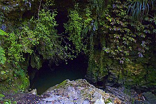
Waitomo is a rural community in the King Country region of New Zealand's North Island. There are several solutional cave systems in the area around the village, which are popular tourist attractions. Restaurants and accommodation are centred in the village to serve visiting tourists.

Kawhia Harbour Place in Waikato region, New Zealand

Kawhia Harbour is one of three large natural inlets in the Tasman Sea coast of the Waikato region of New Zealand's North Island. It is located to the south of Raglan Harbour, Ruapuke and Aotea Harbour, 40 kilometres southwest of Hamilton. Kawhia is part of the Ōtorohanga District Council and is in the King Country. It has a high-tide area of 68 km2 (26 sq mi) and a low-tide area of 18 km2 (6.9 sq mi). Te Motu Island is located in the harbour.

Te Poi Place in Waikato, New Zealand

Te Poi is a small village in rural Waikato, New Zealand, established in 1912 at the base of the Kaimai Range. Te Poi is part of a thriving farming area, particularly for dairying, thoroughbred horse breeding and cropping.

Matauri Bay Locality in Far North District, Northland Region, New Zealand

Matauri Bay is a bay in New Zealand, situated 30 km north of Kerikeri, in Whangaroa county, just north of the Bay of Islands. It has over a kilometre of white sand and crystal clear water, making it a popular summer destinations for surfers, divers, fishers and holidaymakers.

<span class="mw-page-title-main">Pukawa</span> Rural locality in Waikato, New Zealand

Pukawa or Pukawa Bay is a bay and a small township on the southern shores of Lake Taupo on New Zealand's North Island. It is off State Highway 41 between Turangi and Taumarunui, in the Taupo District and Waikato region.

Nukuhau is a suburb of Taupo in the Waikato Region of New Zealand's North Island.

Frasertown Place in Hawkes Bay, New Zealand

Frasertown is a small settlement in the northern Hawke's Bay Region of New Zealand's eastern North Island.

Onewhero Place in Waikato, New Zealand

Onewhero is a village and rural community in the Waikato District and Waikato region of New Zealand's North Island. The village had a population of about 390 in the 2018 New Zealand census;

<span class="mw-page-title-main">Ohinemutu</span> Suburb of Rotorua in New Zealand

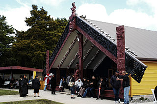
Ohinemutu or Ōhinemutu is a suburb in Rotorua, New Zealand. It includes a living Māori village and the original settlement of Rotorua.

Maniaiti / Benneydale is a small town in the Waitomo District. It is on State Highway 30, approximately 35 km (22 mi) southeast of Te Kuiti.

Tauwhare Suburb of Waikato District in New Zealand

Tauwhare is a small rural community in the Waikato District on the outskirts of Hamilton. The Waitakaruru Arboretum and Sculpture Park is located here.

Waerenga Hamlet in Waikato, New Zealand

Waerenga is the name of a hamlet, 11 km (6.8 mi) east of Te Kauwhata, which is part of a statistical area unit in the Waikato District.

Te Kohanga is a village and rural community in the Waikato District and Waikato region of New Zealand's North Island. It is part of the Onewhero statistical area, which is much larger than this community. The meshblock covering Te Kohanga had a population of 102 in the 2013 New Zealand census.

Okauia is a rural settlement and community located east of Matamata, in the Waikato region of New Zealand's North Island.

Mangatangi Locality in Waikato, New Zealand

Mangatangi is a locality about 7 km east of Mangatawhiri and 10.5 km west of Miranda in the Waikato District in the North Island of New Zealand.

Ngāpuna is a suburb in eastern Rotorua in the Bay of Plenty Region of New Zealand's North Island.

Pokuru is a rural community in the Waipa District and Waikato region of New Zealand's North Island.

Waitahanui is a village in the Taupo District, Waikato region, New Zealand. The village is on the eastern shore of Lake Taupo, 14 km (9 mi) south of the district seat of Taupō.

Oruanui or Ōruanui is a rural community in the Taupo District and Waikato region of New Zealand's North Island, located northwest of Wairakei on State Highway 1.

Waikeria Village in Waikato region, New Zealand

Waikeria is a rural community in the Otorohanga District and Waikato region of New Zealand's North Island.

References

  1. Hariss, Gavin. "Lake Ohakuri, Waikato". topomap.co.nz. NZ Topo Map.
  2. "Māori Maps". maorimaps.com. Te Potiki National Trust.
  3. "Maroanui Marae kitchen project". wairakeitrust.co.nz. Wairakei Trust.
  4. "Maroanui Marae Toilet Block project". wairakeitrust.co.nz. Wairakei Trust.
  5. "Maroanui Marae Extension & Repair Project". wairakeitrust.co.nz. Wairakei Trust.
  6. 1 2 "Statistical area 1 dataset for 2018 Census". Statistics New Zealand. March 2020. Ohakuri (187800). 2018 Census place summary: Ohakuri
  7. "Meshblock Electoral Populations 2020 for proposed boundaries data". Statistics New Zealand. April 2020. Meshblocks 1263500 and 1275201.