
Acadia National Park is an American national park located in the state of Maine, southwest of Bar Harbor. The park preserves about half of Mount Desert Island, many adjacent smaller islands, and part of the Schoodic Peninsula on the coast of Maine. Acadia was initially designated Sieur de Monts National Monument by proclamation of President Woodrow Wilson in 1916. Sieur de Monts was renamed and redesignated Lafayette National Park by Congress in 1919—the first national park in the United States east of the Mississippi River and the only one in the Northeastern United States. The park was renamed Acadia National Park in 1929. More than 3.4 million people visited the park in 2019.

Brooks is a town in Waldo County, Maine, United States. The population was 1,078 at the 2010 census.

Northwood is a town in Rockingham County, New Hampshire, United States. The population was 4,241 at the 2010 census.

Free Will Baptist is a denomination and group of people that believe in free grace, free salvation and free will. The movement can be traced back to the 1600s with the development of General Baptism in England. Its formal establishment is widely linked to the English theologian, Thomas Helwys who led the Baptist movement to believe in general atonement. He was an advocate of religious liberty at a time when to hold to such views could be dangerous and punishable by death. He died in prison as a consequence of the religious persecution of Protestant dissenters under King James I.

The Bronx Kill is a narrow strait in New York City delineating the southernmost extent of the Bronx and separating it from Randalls Island in Manhattan. It connects the Harlem River to the East River.

Brandy Pond, also known as Bay of Naples Lake, is a small lake in Naples, Maine, United States, that is connected to Long Lake by the Chute River. Brandy Pond is connected to Sebago Lake by the Songo River, which runs through Sebago Lake State Park. To get to Sebago Lake through the Songo River, one must pass through Songo Lock, one of the last remaining hand-operated locks in the country.

The Boardman River is a 28.2-mile-long (45.4 km) river that flows into the west arm of Grand Traverse Bay in Traverse City, Michigan. The Boardman's upper tributaries rise near Kalkaska, Michigan, and its watershed drains an area of 295 square miles (760 km2) through 130 miles (210 km) of river and tributaries. The Boardman River is considered one of the top ten trout streams in Michigan. Before entering the Grand Traverse Bay, it becomes Boardman Lake, a natural lake that was originally 259 acres (1.05 km2) in size and increased to 339 acres (137 ha) after the Union Street Dam was constructed in 1867. After flowing through Boardman Lake, the river descends through downtown Traverse City, following a hairpin-shaped course to Grand Traverse Bay. This Traverse City section of the Boardman River is accessible by motorboat from the lakeshore up to a weir upstream from the lakeshore. A short distance upstream from the weir is the Union Street Dam, a small decommissioned mill dam located between Cass and Union streets. The river's principal tributaries are Kids Creek, Beitner Creek, Swainston Creek, and the North and South branches of the river.
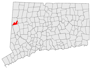
South Kent is a village located in Litchfield County, Connecticut, United States, alongside the border with New York, and within and part of Kent, Connecticut. South Kent has its own Post Office whose ZIP code is 06785. South Kent is also home to South Kent School, a private prep school.

Conway Lake is a 1,316-acre (5 km2) water body with a maximum depth of 45 feet (14 m), located in Carroll County in eastern New Hampshire, in the United States. The lake is located in the towns of Conway and Eaton, just to the east of the White Mountains, and is part of the Saco River watershed.

The Millers River is a 52.1-mile-long (83.8 km) river in northern Massachusetts, originating in Ashburnham and joining the Connecticut River just downstream from Millers Falls, Massachusetts. The river was formerly known as Paquag or Baquag, a Nipmuc word meaning "clear water". Sections of the river are used for whitewater kayaking, and a section upriver is popular with flatwater racers.
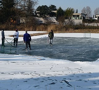
Pond hockey is a form of ice hockey similar in its object and appearance to traditional ice hockey, but simplified and designed to be played on part of a natural frozen body of water. The rink is 50 to 80 percent the size of a standard NHL-specification rink, and has no boards or glass surrounding it; usually only a barrier of snow keeps the puck in play. In addition, because there are no protective barriers behind the goal to contain high errant shots, the top of the goal is lower, in fact only slightly taller than the width of a puck, and the game does not have a formal goalie. Because of these differences, pond hockey places more emphasis on skating and puckhandling ability and less on shooting and checking. Non-competitive pond hockey is played with improvised goals, rinks of a variety of sizes, and no boards or snow barriers. There can only be 4 players playing per team at a time but have many subs to sub in.

The Passagassawaukeag River is a 16-mile-long (26 km) river in Waldo County, Maine in the United States. From the outlet of Lake Passagassawakeag in Brooks, it runs south and east to its estuary in Belfast, Maine. The river empties into Belfast Bay, an inlet of Penobscot Bay, where it passes under US Route 1.

A dam failure or dam burst is a catastrophic type of failure characterized by the sudden, rapid, and uncontrolled release of impounded water or the likelihood of such an uncontrolled release. Between the years 2000 and 2009 more than 200 notable dam failures happened worldwide.

On Golden Pond is a 1981 American drama film directed by Mark Rydell. The screenplay by Ernest Thompson was adapted from his 1979 play of the same name. The film stars Katharine Hepburn and Henry Fonda in the lead roles along with Jane Fonda, Doug McKeon, Dabney Coleman and William Lanteau appearing in supporting roles. The film's narrative revolves around an aged couple, cantankerous retiree Norman Thayer and his conciliatory wife Ethel, who spend summers at their New England vacation home on the shores of idyllic Golden Pond. This year, their adult daughter, Chelsea, visits with her new fiancé and his teenage son, Billy, on their way to Europe. After leaving Billy behind to bond with Norman, Chelsea returns, attempting to repair the long-strained relationship with her aging father before it's too late.

Polar Bear Pass is a 262,400 hectare wetland and mountain pass on Bathurst Island within the Qikiqtaaluk Region, Nunavut, Canada. The pass is on federal Crown land.

Black Pond Wildlife Management Area is a 526-acre (213 ha) New York State Wildlife Management Area (WMA) that lies on the eastern shore of Lake Ontario, and at the northern limit of an unusual region of sandy barrier beaches and lagoons. Much of the barrier beach in Black Pond WMA has forested sand dunes that are about 60 feet (18 m) high; these are the highest sand dunes in the northeast United States excepting Cape Cod. Immediately north of the WMA is the 360-acre (150 ha) El Dorado Beach Preserve, which is a bird refuge owned by The Nature Conservancy. North of the outlet from Black Pond to Lake Ontario, the shoreline is a weathered, flat bedrock shelf that is "calcareous" instead of sandy.
The Roach River is a river in Piscataquis County, Maine. From the outlet of Third Roach Pond in Shawtown, the river runs 19.1 miles (30.7 km) west, through a chain of ponds. The Flow sequence through the ponds is from the Fourth Roach Pond through the Third Roach Pond, Second Roach Pond, and First Roach Pond to empty into Moosehead Lake, the source of the Kennebec River, in Spencer Bay. The Seventh Roach Pond drains through the Sixth Roach Pond in a separate tributary to the Third Roach Pond. No fifth Roach Pond is shown on modern maps.

Shorne Wood Country Park is located between Strood and Gravesend, in the English county of Kent. It was once part of a large estate and then later passed to the county council to be used as a country park.

State Route 203 is part of Maine's system of numbered state highways, located in Waldo County. The route is 4.62 miles (7.44 km) long and runs from SR 131 in Waldo, to SR 139 in Brooks. It is the only state-numbered highway in Maine entirely locally maintained.

Cedar Lake is located northwest of Sled Harbor, New York. Fish species present in the lake are brook trout, black bullhead, and white sucker. There is trail access on the north and west shores from Sled Harbor. There is also trail access to Whitney Lake. No motors are allowed on this lake.

