Lake Pelku

Last updated
Lake Pelku
Lake paiku.jpg
From space, May 1997. North is down.
China Tibet Ngari relief location map.svg
Red pog.svg
Lake Pelku
Location Tibet Autonomous Region
    Shigatse Prefecture
       Gyirong County and Nyalam County
Coordinates 28°55′N85°35′E / 28.917°N 85.583°E / 28.917; 85.583
Type brackish
Primary outflows None (endorheic).
Max. length27 km (17 mi)
Surface elevation4,591 m (15,070 ft)

Lake Pelku [1] (Tibetan : དཔལ་ཁུད་མཚོ, Wylie : dpal khud mtsho, THL : pel khü tso), [2] Pelkhu, [3] or Paiku (Chinese :佩枯错; pinyin :Pèikū Cuò) [a] is a lake at 4,591 meters (15,062 ft) elevation on the Tibetan Plateau in Shigatse Prefecture. It is 18 kilometers (11 mi) south of the Yarlung Tsangpo (Brahmaputra) River, bordering Saga County, Gyirong County, and Nyalam County.

Contents

Lake Paiku in Tibet Lake Paiku in Tibet.jpg
Lake Paiku in Tibet

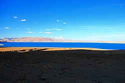
The lake is 27 kilometers (17 mi) long and 6 kilometers (3.7 mi) wide at its narrowest. It is surrounded by mountains reaching 5,700 to 6,000 meters (18,700 to 19,700 ft). Streams fed by glaciers cascade to the valley floor, but most sink into alluvial deposits before reaching the lake.

The surrounding catchment is an endorheic basin with no outlet. It would overflow into the Yarlung Tsangpo with a water level about 100 meters (330 ft) higher. The lake's brackish water is evidence that it has not overflowed in hundreds, if not thousands, of years.

Climate

Climate data for Lake Pelku
MonthJanFebMarAprMayJunJulAugSepOctNovDecYear
Mean daily maximum °C (°F)−0.2
(31.6)
0.6
(33.1)
3.6
(38.5)
7.6
(45.7)
10.7
(51.3)
13.6
(56.5)
12.8
(55.0)
12.3
(54.1)
11.2
(52.2)
7.9
(46.2)
3.3
(37.9)
1.4
(34.5)
7.1
(44.7)
Daily mean °C (°F)−8.1
(17.4)
−7.0
(19.4)
−3.6
(25.5)
0.0
(32.0)
3.3
(37.9)
7.1
(44.8)
7.7
(45.9)
7.3
(45.1)
5.5
(41.9)
0.8
(33.4)
−4.2
(24.4)
−6.5
(20.3)
0.2
(32.3)
Mean daily minimum °C (°F)−15.9
(3.4)
−14.6
(5.7)
−10.8
(12.6)
−7.5
(18.5)
−4.0
(24.8)
0.6
(33.1)
2.7
(36.9)
2.3
(36.1)
−0.1
(31.8)
−6.2
(20.8)
−11.7
(10.9)
−14.3
(6.3)
−6.6
(20.1)
Average precipitation mm (inches)12
(0.5)
9
(0.4)
13
(0.5)
10
(0.4)
7
(0.3)
25
(1.0)
81
(3.2)
86
(3.4)
34
(1.3)
16
(0.6)
1
(0.0)
4
(0.2)
298
(11.8)
Source: Climate-Data.org

Notes

  1. KNAB database lists an alternative form of the Tibean name: Tibetan: པད་ཁུད་མཚོ, Wylie: pad khud mtsho, THL: pé khü tso. [4] Alternative English spellings are: Peiku, Pelgu, Palgu etc.

References

  1. Chan 1994, p. 925.
  2. Tibetan Studies, Volume 256, Part 1, IATS, 1997. p.269
  3. Dorje 2004, p. 326.
  4. "Geographical names of Tibet AR (China): Xigazê Prefecture-Level City". KNAB Place Name Database. Institute of the Estonian Language. 2018-06-03.

Bibliography