The Holocene is the current geological epoch. It began approximately 11,700 years before 2000 CE. It follows the Last Glacial Period, which concluded with the Holocene glacial retreat. The Holocene and the preceding Pleistocene together form the Quaternary period. The Holocene has been identified with the current warm period, known as MIS 1. It is considered by some to be an interglacial period within the Pleistocene Epoch, called the Flandrian interglacial.
The Younger Dryas, which occurred circa 12,900 to 11,700 years BP, was a return to glacial conditions which temporarily reversed the gradual climatic warming after the Last Glacial Maximum (LGM), which lasted from circa 27,000 to 20,000 years BP. The Younger Dryas was the last stage of the Pleistocene epoch that spanned from 2,580,000 to 11,700 years BP and it preceded the current, warmer Holocene epoch. The Younger Dryas was the most severe and longest lasting of several interruptions to the warming of the Earth's climate, and it was preceded by the Late Glacial Interstadial, an interval of relative warmth that lasted from 14,670 to 12,900 BP.

The Last Glacial Period (LGP), also known colloquially as the Last Ice Age or simply Ice Age, occurred from the end of the Eemian to the end of the Younger Dryas, encompassing the period c. 115,000 – c. 11,700 years ago.
Tollmann's bolide hypothesis is a hypothesis presented by Austrian palaeontologist Edith Kristan-Tollmann and geologist Alexander Tollmann in 1994. The hypothesis postulates that one or several bolides struck the Earth around 7640 ± 200 years BCE, and a much smaller one approximately 3150 ± 200 BCE. The hypothesis tries to explain early Holocene extinctions and possibly legends of the Universal Deluge.

Bolshoy Lyakhovsky Island, or Great Lyakhovsky, is the largest of the Lyakhovsky Islands belonging to the New Siberian Islands archipelago between the Laptev Sea and the East Siberian Sea in northern Russia. It has an area of 5,156.6 km2 (1,991.0 sq mi), and a maximum altitude of 311 m (1,020 ft).

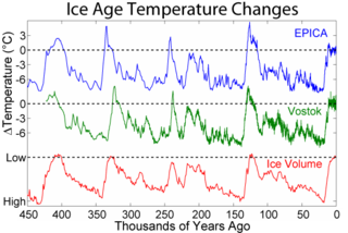
The Last Glacial Maximum (LGM), also referred to as the Last Glacial Coldest Period, was the most recent time during the Last Glacial Period that ice sheets were at their greatest extent 26 ka – 20 ka ago. Ice sheets covered much of Northern North America, Northern Europe, and Asia and profoundly affected Earth's climate by causing a major expansion of deserts, along with a large drop in sea levels.
The Bølling oscillation, also Bølling interstadial, was a cool temperate climatic interstadial between the glacial Oldest Dryas and Older Dryas stadials, between 14,700 and 14,100 BP, near to the end of the last glacial period. It is named after a peat sequence discovered at Bølling lake in central Jutland, Denmark. It is used to describe a period of time in relation to Pollen zone Ib—in regions where the Older Dryas is not detected in climatological evidence, the Bølling–Allerød is considered a single interstadial period.
A Heinrich event is a natural phenomenon in which large groups of icebergs break off from the Laurentide Ice Sheet and traverse the Hudson Strait into the North Atlantic. First described by marine geologist Hartmut Heinrich, they occurred during five of the last seven glacial periods over the past 640,000 years. Heinrich events are particularly well documented for the last glacial period but notably absent from the penultimate glaciation. The icebergs contained rock mass that had been eroded by the glaciers, and as they melted, this material was dropped to the sea floor as ice rafted debris forming deposits called Heinrich layers.
An interglacial period is a geological interval of warmer global average temperature lasting thousands of years that separates consecutive glacial periods within an ice age. The current Holocene interglacial began at the end of the Pleistocene, about 11,700 years ago.
The Bølling–Allerød interstadial, also called the Late Glacial Interstadial, was an abrupt warm and moist interstadial period that occurred during the final stages of the Last Glacial Period. This warm period ran from 14,690 to 12,890 years before the present (BP). It began with the end of the cold period known as the Oldest Dryas, and ended abruptly with the onset of the Younger Dryas, a cold period that reduced temperatures back to near-glacial levels within a decade.

Lake Jackson is a shallow, prairie lake on the north side of Leon County, Florida, United States, near Tallahassee, with two major depressions or sinkholes known as Porter Sink and Lime Sink.
Superficial deposits refer to geological deposits typically of Quaternary age. These geologically recent unconsolidated sediments may include stream channel and floodplain deposits, beach sands, talus gravels and glacial drift and moraine. All pre-Quaternary deposits are referred to as bedrock.
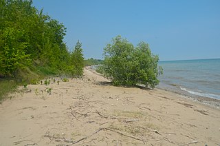
Two Creeks Buried Forest State Natural Area is a site in the Wisconsin State Natural Areas Program and a unit of the Ice Age National Scientific Reserve. The site lies in the northeast corner of Manitowoc County on the shore of Lake Michigan north of Two Creeks, Wisconsin, USA. Periodically exposed in a steep lakeshore bluff is a stratum of sediment, known as the Two Creeks forest bed. It contains stumps, logs, branches, pine needles, pinecones, moss, and other forest litter and is sandwiched between layers of glacial till. This is an important site in Great Lakes geochronology because it firmly establishes the timeframe of advances and retreats during the last glacial period in this region.

Bond events are North Atlantic ice rafting events that are tentatively linked to climate fluctuations in the Holocene. Eight such events have been identified. Bond events were previously believed to exhibit a roughly c. 1,500-year cycle, but the primary period of variability is now put at c. 1,000 years.

Postglacial vegetation refers to plants that colonize the newly exposed substrate after a glacial retreat. The term "postglacial" typically refers to processes and events that occur after the departure of glacial ice or glacial climates.

The Southeastern conifer forests are a temperate coniferous forest ecoregion of the southeastern United States. It is the largest conifer forest ecoregion east of the Mississippi River. It is also the southernmost instance of temperate coniferous forest within the Nearctic realm.

The Idaho Batholith ecoregion is a Level III ecoregion designated by the United States Environmental Protection Agency (EPA) in the U.S. states of Idaho and Montana. It is contained within the following biomes designated by the World Wild Fund for Nature (WWF): temperate coniferous forests; temperate grasslands, savannas, and shrublands; and deserts and xeric shrublands.

The Vashon Glaciation, Vashon Stadial or Vashon Stade is a local term for the most recent period of very cold climate in which during its peak, glaciers covered the entire Salish Sea as well as present day Seattle, Tacoma, Olympia and other surrounding areas in the western part of present-day Washington (state) of the United States of America. This occurred during a cold period around the world known as the last glacial period. This was the most recent cold period of the Quaternary glaciation, the time period in which the arctic ice sheets have existed. The Quaternary Glaciation is part of the Late Cenozoic Ice Age, which began 33.9 million years ago and is ongoing. It is the time period in which the Antarctic ice cap has existed.
Sidney Hemming is an analytical geochemist known for her work documenting Earth's history through analysis of sediments and sedimentary rocks. She is a professor of earth and environmental sciences at Columbia University.
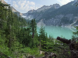
An alpine lake is a high-altitude lake in a mountainous area, usually near or above the tree line, with extended periods of ice cover. These lakes are commonly glacial lakes formed from glacial activity but can also be formed from geological processes such as volcanic activity or landslides. Many alpine lakes that are fed from glacial meltwater have the characteristic bright turquoise green color as a result of glacial flour, suspended minerals derived from a glacier scouring the bedrock. When active glaciers are not supplying water to the lake, such as a majority of Rocky Mountains alpine lakes in the United States, the lakes may still be bright blue due to the lack of algal growth resulting from cold temperatures, lack of nutrient run-off from surrounding land, and lack of sediment input. The coloration and mountain locations of alpine lakes attract lots of recreational activity.
