Related Research Articles

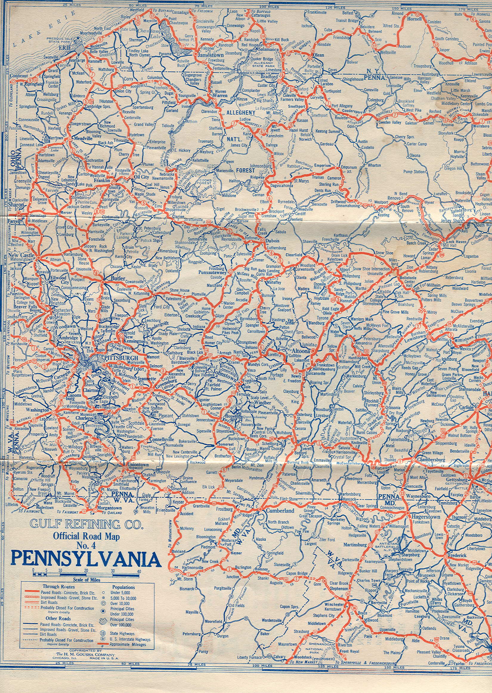
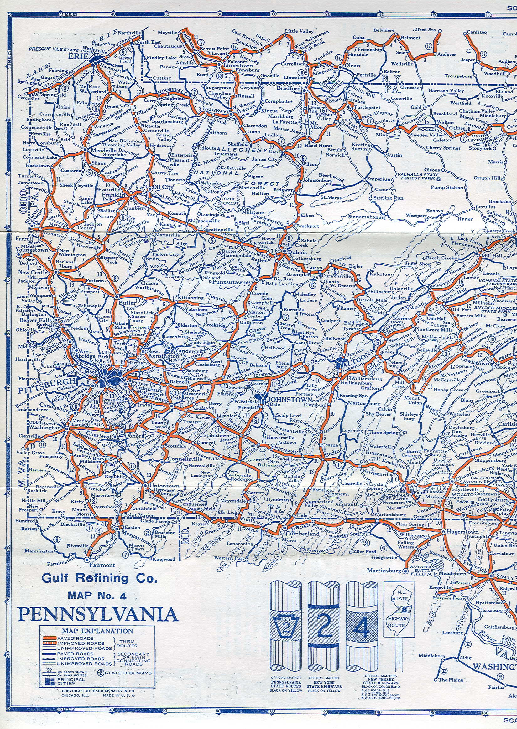
U.S. Route 322 is a 494-mile-long (795.0 km), east–west United States Highway, traversing Ohio, Pennsylvania, and New Jersey. The road is a spur of US 22 and one of the original highways from 1926. A portion of it at one time was concurrent with the Lakes-to-Sea Highway.
Pennsylvania Route 5 is a westward continuation of New York State Route 5. Located in the Commonwealth of Pennsylvania, in the United States, it runs from North East, Pennsylvania at the New York-Pennsylvania border to Springfield Township in western Erie County, for a total of 44.85 miles (72.18 km).

U.S. Route 6 (US 6) travels east–west near the north edge of the U.S. state of Pennsylvania from the Ohio state line near Pymatuning Reservoir east to the Mid-Delaware Bridge over the Delaware River into Port Jervis, New York. It is the longest highway segment in the commonwealth. Most of it is a two-lane rural highway, with some freeway bypasses around larger towns. Except east of Dunmore, where it is paralleled by Interstate 84 (I-84), it is the main route in its corridor. What is now I-80—the Keystone Shortway—was once planned along the US 6 corridor as a western extension of I-84. The corridor was originally the Roosevelt Highway from Erie, Pennsylvania, to Port Jervis, New York, designated Pennsylvania Route 7 (PA 7) in 1924. The PA 7 designation soon disappeared, but, as US 6 was extended and relocated, the Roosevelt Highway followed it. The Pennsylvania section of US 6 was renamed the Grand Army of the Republic Highway in 1946; this name was applied to its full transcontinental length by 1953.

Pennsylvania Route 3 is a 24.3-mile (39.1 km) state highway located in the southeastern portion of Pennsylvania. The route runs from U.S. Route 322 Business in West Chester east to PA 611 in Philadelphia.
Pennsylvania Route 99, officially SR 699, is a 21-mile-long (34 km) state highway located in western Pennsylvania. The southern terminus is at U.S. Route 6 and US 19 in Cambridge Springs. The northern terminus is at US 19 near Erie.
Pennsylvania Route 86 is a 12.4-mile-long (20.0 km) state highway in Crawford County, Pennsylvania, United States. The northern terminus of the route is at U.S. Route 6, U.S. Route 19, and Pennsylvania Route 408 in Cambridge Springs. The southern terminus is at Pennsylvania Route 27 in Meadville.

Pennsylvania Route 291 is an east–west state route in Pennsylvania that runs from U.S. Route 13 and US 13 Business in Trainer, Delaware County, east to Interstate 76 (I-76) in South Philadelphia near the Walt Whitman Bridge and the South Philadelphia Sports Complex. Except for a short 1-mile (1.6 km) section between the western terminus and the Chester/Trainer line, PA 291 is mostly a four-lane highway. From the western terminus to the eastern part of Chester, the route has a concurrency with US 13. It runs parallel to the Delaware River for much of the route. The route passes through industrial areas near the river in Delaware County, serving Chester, Eddystone, Essington, and Lester. PA 291 enters Philadelphia near the Philadelphia International Airport, at which point it has an interchange with I-95. The route crosses the Schuylkill River on the George C. Platt Memorial Bridge and continues along Penrose Avenue to I-76. It has been designated the Industrial Heritage Highway.

Pennsylvania Route 27 is a 65.7-mile-long (105.7 km) state highway that is located in northwest Pennsylvania in the United States.
Pennsylvania Route 77 is a 36-mile-long (58 km) east–west state highway located in northwest Pennsylvania. The western terminus of the route is at PA 27 in Meadville. The eastern terminus is at PA 426 in Corry.

Pennsylvania Route 98 is a state highway located in western Pennsylvania. The southern terminus of the route is at U.S. Route 6 (US 6)/US 19/US 322 in Vernon Township. The northern terminus is at PA 5 in the borough of Avonia, one mile (1.6 km) from Lake Erie.

Pennsylvania Route 97 is one of two Pennsylvania state highways that carries the PA 97 designation; the other PA 97 is in Adams County. This northern PA 97, 21 miles (34 km) in length, is a north-south highway that terminates at PA 8 at both ends. The southern terminus is in Union City and the northern terminus is in Erie. The Pennsylvania Department of Transportation (PennDOT) internally designates this road SR 0197 to distinguish it from the other PA 97.

Pennsylvania Route 340 (PA 340) is a 30-mile-long (48 km) state highway located in Lancaster and Chester counties in Pennsylvania. The western terminus is at PA 462 in Lancaster. The eastern terminus is at U.S. Route 30 Business in Thorndale. The route is a two-lane road passing through rural areas, heading through the Pennsylvania Dutch Country in eastern Lancaster County that is home to several Amish families and rural areas in western Chester County, serving the communities of Bird-in-Hand, Intercourse, White Horse, Compass, and Wagontown. PA 340 intersects US 30 near Lancaster, PA 772 in Intercourse, PA 897 in White Horse, PA 10 in Compass, PA 82 near Coatesville, and US 30 again near Thorndale.
U.S. Route 322 is a spur of US 22, running from Cleveland, Ohio, east to Atlantic City, New Jersey. In the U.S. state of Pennsylvania, the route runs from the Ohio state line in West Shenango Township southeast to the Commodore Barry Bridge over the Delaware River in Chester, at which point the route crosses into New Jersey, meeting the New Jersey Turnpike at exit 2. The route passes near or through several cities, including Meadville, DuBois, State College, and Harrisburg. US 322 in Pennsylvania is named the 28th Division Highway in honor of the 28th Infantry Division.

Pennsylvania Route 832, known locally as Sterrettania Road and Peninsula Drive, is a state highway located in Erie County, Pennsylvania. Its northern terminus is at the entrance to Presque Isle State Park in Erie. The southern terminus is at PA 98, two miles (3 km) west of Sterrettania in Fairview Township. PA 832 has junctions with U.S. Route 20, PA 5 and PA 5 Alternate. PA 832 is exit 18 off Interstate 90 (I-90). PA 832 was designated in 1928 between PA 99 and Presque Isle. The route was extended south to US 20 by 1940. PA 832 was further extended to I-90 by 1959 and PA 98 by 1970.

Pennsylvania Route 842 is a state highway in Chester County, Pennsylvania. The route runs from PA 841 in West Marlborough Township to U.S. Route 322 Business in downtown West Chester. PA 842 runs through rural areas with some development between PA 841 and West Chester as a two-lane undivided road. Along this stretch, the route forms a concurrency with PA 82 in Unionville, where it intersects the western terminus of PA 162. In West Chester, PA 842 is routed along one-way streets. PA 842 was first designated by 1928 between PA 82 in Unionville and US 122/PA 5/PA 62 in West Chester. The route was extended west to PA 841 in 1937.
U.S. Route 322 Business is a business route of US 322 in the borough and surrounding townships of West Chester in Chester County, Pennsylvania. US 322 bypasses West Chester to the north and east on the West Chester Bypass while US 322 Bus. heads through the downtown area. The business route begins at US 322 northwest of the borough and heads southeast, entering West Chester on Hannum Avenue. US 322 Bus. heads east into downtown West Chester along the one-way pair of West Market and West Chestnut streets. In the center of the borough, the route heads south along South High Street, passing through the West Chester University of Pennsylvania campus as it leaves the borough. US 322 Bus. comes to its eastern terminus at an interchange with US 202/US 322 at the southern terminus of the bypass.

U.S. Route 13 (US 13) is a United States Numbered Highway running from Fayetteville, North Carolina, north to Morrisville, Pennsylvania. The route runs for 49.359 miles (79.436 km) through the Delaware Valley metropolitan area in the U.S. state of Pennsylvania. The route enters the state from Delaware in Marcus Hook, Delaware County. It continues northeast through Delaware County, passing through the city of Chester before heading through suburban areas along Chester Pike to Darby. US 13 enters the city of Philadelphia on Baltimore Avenue and runs through West Philadelphia to University City, where it turns north along several city streets before heading east across the Schuylkill River along Girard Avenue. The route turns north and heads to North Philadelphia, where it runs northeast along Hunting Park Avenue. US 13 becomes concurrent with US 1 on Roosevelt Boulevard, continuing into Northeast Philadelphia. US 13 splits southeast on a one-way pair of streets before heading northeast out of the city on Frankford Avenue. The route continues into Bucks County as Bristol Pike, heading northeast to Bristol, where it becomes a divided highway. US 13 becomes a freeway in Tullytown and continues north to its terminus at US 1 in Falls Township, near Morrisville. US 13 roughly parallels Interstate 95 (I-95) through its course in Pennsylvania.

Pennsylvania Route 102, also known as Cussewago Road, is a 4.3-mile-long (6.9 km), north-south state highway located in Crawford County in Pennsylvania. The southern terminus is at U.S. Route 6 /US 19/US 322 in Vernon Township. The northern terminus is at PA 98 in Vernon Township.

The Beaver and Erie Canal, also known as the Erie Extension Canal, was part of the Pennsylvania Canal system and consisted of three sections: the Beaver Division, the Shenango Division, and the Conneaut Division. The canal ran 136 miles (219 km) north–south near the western edge of the state from the Ohio River to Lake Erie through Beaver County, Lawrence County, Mercer County, Crawford County, and Erie County, Pennsylvania.

U.S. Route 19 (US 19) in Pennsylvania is closely paralleled by Interstate 79 (I-79) for its entire length. US 19 enters Pennsylvania from West Virginia in Greene County near Mount Morris. Its northern terminus is at US 20 in the city of Erie. Part of it is named for Commodore Oliver Hazard Perry, hero of the Battle of Lake Erie.
References
If an internal link led you here, you may wish to change the link to point directly to the intended article.