
Regina is the capital city of the Canadian province of Saskatchewan. The city is the second-largest in the province, after Saskatoon, and is a commercial centre for southern Saskatchewan. As of the 2021 census, Regina had a city population of 226,404, and a Metropolitan Area population of 249,217. It is governed by Regina City Council. The city is surrounded by the Rural Municipality of Sherwood No. 159.

Regina International Airport is an international airport located in Regina, Saskatchewan, Canada, located 2 nautical miles south-west and 7 km (4.3 mi) west-southwest of the city centre. It is run by the Regina Airport Authority. In 2022, it was the 16th busiest airport in Canada.
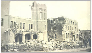
The Regina Cyclone, or Regina tornado of 1912, was a tornado that devastated the city of Regina, Saskatchewan, Canada, on Sunday, June 30, 1912. It remains the deadliest tornado in Canadian history with a total of 28 fatalities and about 300 people injured. At about 4:50 p.m., green funnel clouds formed and touched down south of the city, tearing through the residential area between Wascana Lake and Victoria Avenue, and continuing through the downtown business district, rail yards, warehouse district, and northern residential area.

Regina Wascana Plains is a provincial electoral district for the Legislative Assembly of Saskatchewan, Canada. At different points in time, this district included the Regina neighbourhoods of University Park, University Park East, Arcola East-South Side, Varsity Park, Wood Meadows, Woodland Grove, Wascana View, Wascana Crescents and Wascana Park. It also includes the town of White City.

Regina Northeast is a provincial electoral district for the Legislative Assembly of Saskatchewan, Canada. This district includes the neighbourhoods of Parkridge, Uplands, Glencairn and Glencairn Village.

Regina—Wascana is a federal electoral district in Saskatchewan, Canada, that has been represented in the House of Commons of Canada since 1988.

Government House, Regina, Saskatchewan, Canada, was constructed as a residence for the lieutenant governor of the North-West Territories, whose territorial headquarters were in Regina until the provinces of Saskatchewan and Alberta were created out of the Territories in 1905 and Regina became the capital of Saskatchewan.
Ring Road is a 4 lane controlled access highway in Regina, Saskatchewan, Canada. Ring Road is a partial ring road or beltway that forms a partial circle around Regina, bypasses the city on the north, east, and south sides, with Lewvan Drive and Pasqua Street N functioning as the de facto western leg. East of Pasqua Street, Ring Road continues west as 9th Avenue N, an arterial road. Ring Road has a speed limit of 100 km/h (60 mph) and consists of 13 interchanges.
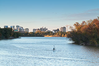
Wascana Centre is a 930-hectare urban park built around Wascana Lake in Regina, Saskatchewan, Canada, established in 1912 with a design from renowned architect Thomas Mawson. The park is designed around the Saskatchewan Legislative Building and Wascana Lake. High-profile features include the University of Regina, Royal Saskatchewan Museum, Conexus Arts Centre, Saskatchewan Science Centre, and CBC Regional Broadcast Centre. Wascana Centre brings together lands and buildings owned by the City of Regina, University of Regina, and Province of Saskatchewan. The park is located immediately south of the city's downtown core, bordered by residential areas on the east, south and west, and on the south-east edge it spills out onto open Saskatchewan prairie along Wascana Creek.

Many historically significant buildings in Regina, Saskatchewan were lost during the period 1945 through approximately 1970 when the urge to "modernize" overtook developers' and city planners' sense of history and heritage. The old warehouse district to the north of the old CPR tracks was Regina's original commercial raison d'être once Lieutenant-Governor Edgar Dewdney had established the site of his considerable landholdings as the Territorial Capital. 1899 to 1919 Washington Park and 3431 Dewdney Ave building as CPR commercial logistics building, expanded connected with significant conversion of shipping of commercial goods from train to truck and cancellation of passenger service on the railway, the Warehouse District immediately adjacent to the train line has ceased to be exclusively industrial in character. Some areas of the Warehouse District have been transformed into a shopping, entertainment and residential precinct.

Nutana is a primarily residential neighbourhood located near the centre of Saskatoon, Saskatchewan, Canada. It includes the business district of Broadway Avenue. It comprises a nearly even mixture of low-density, single detached dwellings and apartment-style multiple unit dwellings. As of 2009, the area is home to 6,261 residents. The neighbourhood is considered a middle to upper-income area, with an average family income of $67,657, an average dwelling value of $206,830 and a home ownership rate of 51.3%. First established in 1883, Nutana was the original settlement of what now makes up the city of Saskatoon.

Varsity View is a mostly residential neighbourhood located near central Saskatoon, Saskatchewan, Canada. It is immediately south of the University of Saskatchewan campus. It is an older suburban subdivision, comprising a mixture of low-density, single detached dwellings, detached duplexes and apartment-style units. As of 2007, the area is home to 3,611 residents. The neighbourhood is considered a middle-income area, with an average family income of $50,587, an average dwelling value of $284,710 and a home ownership rate of 38.7%. Its proximity to the university gives this area its relatively high student population, almost 25% in 2005.

Caswell Hill is a district in the city of Saskatoon, Saskatchewan, Canada. It derives its name from an early homesteader Robert Caswell one of the Temperance Colonists of 1883. It is an area of beautiful character homes first built ca. 1905, tiny war-time houses, and newer houses. Caswell is a thriving and diverse community nestled between two economic areas, the downtown core, and the stores lining 33rd Street West.

Mayfair is a neighbourhood in the city of Saskatoon, Saskatchewan, Canada. Mayfair started out as a community outside of the villages of Riversdale, Nutana and Saskatoon and appears as its own place name on a map of 1907. In 1909 there were 60 residences built in Mayfair, and in 1911, the City of Saskatoon had grown large enough to encompass Mayfair. Homeownership amongst the residents is at 68.2%.

Lakeview is a primarily residential neighbourhood located in the southeast part of Saskatoon, Saskatchewan, Canada. The majority of its residents live in low-density, single detached dwellings, with a sizeable minority of semi-detached or apartment-style multiple unit dwellings. As of 2011, the area is home to 7,732 residents. The neighbourhood is considered a high income area, with an average family income of $120,042, an average dwelling value of $277,070 and a home ownership rate of 71.0%. It was the first community in Saskatoon to feature a man-made lake amenity.

Seven neighbourhoods are of considerable note:
The Wascana Trails are a series of interconnected hiking and mountain biking trails in the Canadian province of Saskatchewan, offering 15 km of marked trails. The trails are located 8 km north-west of Regina in the RM of Sherwood No. 159 in a deep ravine carrying a tributary of the Qu'Appelle River called Wascana Creek.

Knox-Metropolitan United Church stands on Lorne Street at Victoria Avenue across from Victoria Park in downtown Regina, Saskatchewan, Canada. It is the current manifestation of Presbyterian and Methodist congregations that date back to "worship services in both traditions…in 1882."
Normanview West is a primarily residential neighbourhood in the west end of Regina, Saskatchewan. It is bordered by 9th avenue to the north, the rail line to the west, and McCarthy road to the east.
Albert Street is an arterial road in Regina, Saskatchewan. It is one of the main roads in and out of the downtown area of the city. It is named in honour of Prince Albert, the husband and consort of Queen Victoria, and intersects Victoria Avenue in centre of the city.

