
Uttar Pradesh is a state in northern India. With over 241 million inhabitants, it is the most populated state in India as well as the most populous country subdivision in the world – more populous than all but four countries – accounting for 16.5% of the total population of India. It was established in 1950 after India had become a republic. It is a successor to the United Provinces, established in 1935 by renaming of the United Provinces of Agra and Oudh, in turn established in 1902 from the North-Western Provinces and the Oudh Province. Lucknow serves as the state capital, with Prayagraj being the judicial capital.

Mirzapur is a city in Uttar Pradesh, India, 827 km from Delhi and 733 km from Kolkata, almost 91 km from Prayagraj and 61 km from Varanasi. It is known for its carpets and brassware industries, and the folk tradition of kajri and birha music. The city is surrounded by several hills of the Maikal range and is the headquarters of Mirzapur district.

Purvanchal is a proposed state in the Bhojpuri region of eastern Uttar Pradesh.

Jaunpur is a city and a municipal board in Jaunpur district in the Indian state of Uttar Pradesh. It is located 228 km southeast of state capital Lucknow. Demographically, Jaunpur resembles the rest of the Purvanchal area in which it is located.

Chandauli district is a district of Uttar Pradesh state of India, and Chandauli town is the district headquarters. Chandauli district is a part of Varanasi Division. Chandauli became a separate district for the first time on 20 May 1997.

Varanasi district is a district in the north Indian state of Uttar Pradesh, with the holy city of Varanasi as the district headquarters. It is also the headquarters of the Varanasi Division which contains 4 districts.

Mirzapur district is one of the 75 districts in the Indian state of Uttar Pradesh. The district is bounded on the north by Bhadohi and Varanasi districts, on the east by Chandauli district, on the south by Sonbhadra district and on the northwest by Prayagraj. The district occupies an area of 4521 km2. Mirzapur city is the district headquarters. Mirzapur district is a part of Mirzapur division. This district is known for the Vindhyavasini temple in Vindhyachal and several tourist attractions like water falls like Rajdari & Devdari and dams. It consist of several Ghats where historical sculptures are still present. During the Ganges festival these Ghats are decorated with lights and diyas.

Chitrakoot Dham is a city in the Chitrakoot district, within the state of Uttar Pradesh, India. It is the headquarters of the Chitrakoot district. Situated in the Bundelkhand region, it holds great cultural, historical, religious and archaeological importance and it is said that Lord Rama spent 11 years of exile in Chitrakoot. It is connected to the town of Chitrakoot, situated in the Satna district of Madhya Pradesh.
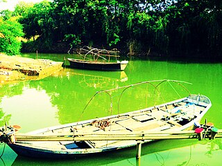
The Varuna River is a minor tributary of the Ganges River in Uttar Pradesh, India. It originates at Phulpur in the Prayagraj district and merges into the Ganges near Sarai Mohana in the Varanasi district. The 6 kilometres (3.7 mi) stretch between Sarai Mohana and Sadar, Varanasi, Uttar Pradesh is prone to flooding. The name 'Varanasi' is originated from the name of two rivers, Varuna and Assi.

Lal Bahadur Shastri International Airport is an international airport serving Varanasi, Uttar Pradesh, India. It is located at Babatpur, 26 km (16 mi) northwest of Varanasi. Formerly known as Varanasi Airport, it was officially renamed after Lal Bahadur Shastri, the 2nd Prime Minister of India, in October 2005. It is the 20th-busiest airport in India in terms of passenger movement, and the second-busiest airport in Uttar Pradesh. The airport is awarded as the best airport in Asia-Pacific in 2020 by Airports Council International.

Uttar Pradesh is the most populous state in India with a population of nearly 200 million people. The economy of Uttar Pradesh is the third largest of all the states in India. At current prices, the gross state domestic product (GSDP) of Uttar Pradesh is estimated to be Rs. 20.48 trillion in 2022–23. Merchandise exports from Uttar Pradesh reached US$21.03 billion in FY22.
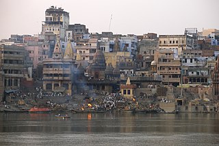
Varanasi is a city on the Ganges river in northern India that has a central place in the traditions of pilgrimage, death, and mourning in the Hindu world. The city has a syncretic tradition of Muslim artisanship that underpins its religious tourism. Located in the middle-Ganges valley in the southeastern part of the state of Uttar Pradesh, Varanasi lies on the left bank of the river. It is 692 kilometres (430 mi) to the southeast of India's capital New Delhi and 320 kilometres (200 mi) to the east of the state capital, Lucknow. It lies 121 kilometres (75 mi) downstream of Prayagraj, where the confluence with the Yamuna river is another major Hindu pilgrimage site.
Rohaniya is a constituency of the Uttar Pradesh Legislative Assembly covering the city of Rohaniya in the Varanasi district of Uttar Pradesh, India. It is a Patel-Bhumihar dominant seat. The constituency number is 387. Rohaniya is one of five assembly constituencies in the Varanasi Lok Sabha constituency. Since 2008, this assembly constituency is numbered 387 amongst 403 constituencies.
Varanasi North is a constituency of the Uttar Pradesh Legislative Assembly covering the city of Varanasi North in the Varanasi district of Uttar Pradesh, India.
Varanasi South is a constituency of the Uttar Pradesh Legislative Assembly covering the city of Varanasi South in the Varanasi district of Uttar Pradesh, India.
Sevapuri is a constituency of the Uttar Pradesh Legislative Assembly covering the city of Sevapuri in the Varanasi district of Uttar Pradesh, India.
Varanasi Cantonment is a constituency of the Uttar Pradesh Legislative Assembly covering the city of Varanasi Cantonment in the Varanasi district of Uttar Pradesh, India.
Pindra is one of the 403 constituencies of the Uttar Pradesh Legislative Assembly, India. It is a part of the Varanasi district and one of the five assembly constituencies in the Machhlishahr Lok Sabha constituency. Pindra Assembly constituency came into existence in 2008 as a result of the "Delimitation of Parliamentary and Assembly Constituencies Order, 2008".
Shivpur Assembly constituency is one of the 403 constituencies of the Uttar Pradesh Legislative Assembly, India. It is a part of the Varanasi district and one of the five assembly constituencies in the Chandauli Lok Sabha constituency. First election in this assembly constituency was held in 2012 after constituency came into existence when "Delimitation of Parliamentary and Assembly Constituencies Order, 2008" was passed in the year 2008.
Bachaura is a village in Pindra Tehsil of Varanasi district in the Indian state of Uttar Pradesh. The village falls under gram panchayat by the same name as the village. The village is about 34 kilometers North-West of Varanasi city, 273 kilometers South-East of state capital Lucknow and 794 kilometers South-East of the national capital Delhi.


