Papua New Guinea, officially the Independent State of Papua New Guinea, is a country in Oceania that occupies the eastern half of the island of New Guinea and its offshore islands in Melanesia, a region of the southwestern Pacific Ocean north of Australia. Its capital, located along its southeastern coast, is Port Moresby. The western half of New Guinea forms the Indonesian provinces of Papua and West Papua. It is the world's third largest island country with 462,840 km2 (178,700 sq mi).

Port Moresby, also referred to as Pom City or simply Moresby, is the capital and largest city of Papua New Guinea and the largest city in the South Pacific outside of Australia and New Zealand. It is located on the shores of the Gulf of Papua, on the south-western coast of the Papuan Peninsula of the island of New Guinea. The city emerged as a trade centre in the second half of the 19th century. During World War II it was a prime objective for conquest by the Imperial Japanese forces during 1942–43 as a staging point and air base to cut off Australia from Southeast Asia and the Americas.
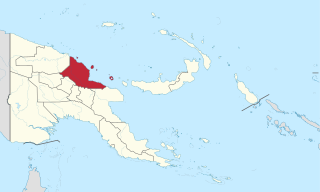
The Sko or Skou languages are a small language family spoken by about 7000 people, mainly along the Vanimo coast of Sandaun Province in Papua New Guinea, with a few being inland from this area and at least one just across the border in the Indonesian province of Papua.

The Bismarck Sea lies in the southwestern Pacific Ocean within the nation of Papua New Guinea. It is located northeast of the island of New Guinea and south of the Bismarck Archipelago. It has coastlines in districts of the Islands Region, Momase Region, and Papua Region.
Madang is a province of Papua New Guinea. The province is on the northern coast of mainland Papua New Guinea and has many of the country's highest peaks, active volcanoes and its biggest mix of languages. The capital is the town of Madang.
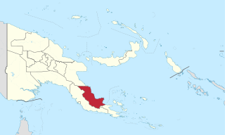
Oro Province, formerly Northern Province, is a coastal province of Papua New Guinea. The provincial capital is Popondetta. The province covers 22,800 km2, and has 176,206 inhabitants. The province shares land borders with Morobe Province to the northwest, Central Province to the west and south, and Milne Bay Province to the southeast. The province is located within the Papuan Peninsula.

Misima is a volcanic island in the northwest of Louisiade Archipelago within Milne Bay Province of Papua New Guinea.
Wutung (Udung) and Sangke (Nyao) are a Skou language or pair of languages of Papua New Guinea. It is spoken in the villages of Wutung and Sangke in Bewani-Wutung Onei Rural LLG of Sandaun Province. The two varieties are sometimes considered separate languages.

The Eastern Trans-Fly languages are a small independent family of Papuan languages spoken in the Oriomo Plateau to the west of the Fly River in New Guinea.
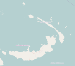
Konoagil Rural LLG is a local government area in New Ireland Province, Papua New Guinea. The LLG administers the southern peninsula of the island of New Ireland. The LLG is located in Namatanai District and its population is 10,503. Languages in the area are Siar-Lak language, Kandas language, and Label language.

New Guinea is the world's second-largest island and, with an area of 785,753 km2 (303,381 sq mi), the largest island in the Southern Hemisphere. Located in Melanesia in the southwestern Pacific Ocean, it is separated by the 150-kilometre wide Torres Strait from the Australian continent. Numerous smaller islands are located to the west and east. The eastern half of the island is the major land mass of the independent state of Papua New Guinea. The western half, known as Western New Guinea or West Papua, forms a part of Indonesia and is organized as the provinces of Papua and West Papua.
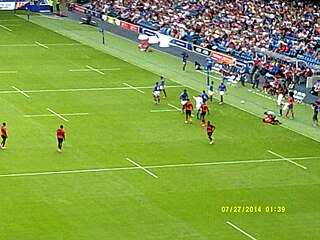
The Papua New Guinea national rugby sevens team competes in the Oceania Sevens, where they finished third in 2009, and fourth in 2010, 2015 and 2016.

The 2000 New Ireland earthquakes occurred off the coast of New Ireland Province, Papua New Guinea on November 16 and 17.
Gasmata is a village on the southern coast of New Britain, Papua New Guinea located at 6° 16' 60S 150° 19' 60E. There is a Gasmata Airport in Surumi Peninsula area adjacent. The village is administered under Gasmata Rural LLG in East New Britain Province.

Abun, also known as Yimbun, Anden, Manif, or Karon, is a Papuan language spoken along the northern coast of the Bird's Head Peninsula in Abun District, Tambrauw Regency. It is not closely related to any other language, and though Ross (2005) assigned it to the West Papuan family, based on similarities in pronouns, Palmer (2018), Ethnologue, and Glottolog list it as a language isolate.
Waskia is a Papuan language of Papua New Guinea. It is spoken on half of Karkar Island, and a small part of the shore on the mainland, by 20,000 people; language use is vigorous. The Waskia share their island with speakers of Takia, an Oceanic language which has been restructured under the influence of Waskia, which is the inter-community language. Waskia has been documented extensively by Malcolm Ross and is being further researched by Andrew Pick.
Siar, also known as Lak, Lamassa, or Likkilikki, is an Austronesian language spoken in New Ireland Province in the southern island point of Papua New Guinea. Lak is in the Patpatar-Tolai sub-group, which then falls under the New Ireland-Tolai group in the Western Oceanic language, a sub-group within the Austronesian family. The Siar people keep themselves sustained and nourished by fishing and gardening. The native people call their language ep warwar anun dat, which means "our language".

Kabaman is a village on the south-west coast of New Ireland, Papua New Guinea, south of Kait and north of Lamassa. The people speak the Siar-Lak language. It is located in Konoagil Rural LLG.
Lamassa Island is an island in Lamassa Bay off the village of Lamassa off the south-western coast of New Ireland, Papua New Guinea. It contains Lamassa Airport and a village on the north coast.
Lambom is a village on the south-west coast of New Ireland, Papua New Guinea, south of Lamassa. Lambom Island lies off the coast. It is located in Konoagil Rural LLG.