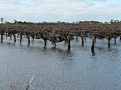
The Coonawarra wine region is a wine region centred on the town of Coonawarra in the Limestone Coast zone of South Australia. It is known for the Cabernet Sauvignon wines produced on its "terra rossa" soil. The name has been said to have originated in Bindjali, an Aboriginal language, meaning "wild honeysuckle". It is about 380 kilometres (240 mi) south-east of Adelaide, close to the border with Victoria.

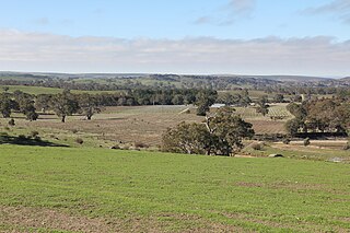
Wrattonbully is a wine region in South Australia's South East, between the Padthaway and Coonawarra regions, between the Riddoch Highway and the Victorian border.

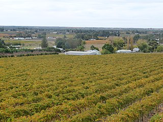
The Clare Valley wine region is one of Australia's oldest wine regions, best known for Riesling wines. It lies in the Mid North of South Australia, approximately 142 km north of Adelaide. The valley runs north-south, with Horrocks Highway as the main thoroughfare.
The Mount Benson wine region is a wine region in the south east of South Australia located on the continental coastline about 300 kilometres from Adelaide and halfway between the towns of Kingston SE and Robe. Mount Benson is one of six wine growing regions that are located in the Limestone Coast wine zone.

Langhorne Creek is a town in South Australia. At the 2016 census, Langhorne Creek had a population of 427.

The South Australian wine industry is responsible for more than half the production of all Australian wine. South Australia has a vast diversity in geography and climate which allows the state to be able to produce a range of grape varieties–from the cool climate Riesling variety in the Clare Valley wine region to the big, full bodied Shiraz wines of the Barossa Valley.
Eden Valley wine region is a wine region located in South Australia immediately north of the capital city of Adelaide which covers an area in the Mount Lofty Ranges extending from Truro in the north to just south of Springton in the south. The region received appellation as an Australian Geographical Indication in 1997 and as of 2014, it is represented by at least 36 wineries.

Fleurieu zone is a wine zone located south of Adelaide in South Australia. It extends from Kangaroo Island in the west as far north as Flagstaff Hill on the west side of the Mount Lofty Ranges and to as far north as Langhorne Creek on the east side of the Mount Lofty Ranges. It consists of the following five wine regions, each of which has received appellation as an Australian Geographical Indication (AGI): Currency Creek, Kangaroo Island, Langhorne Creek, McLaren Vale and the Southern Fleurieu.

Kangaroo Island wine region is a wine region which covers the full extent of Kangaroo Island in South Australia. The wine region is one of five wine regions comprising the Fleurieu zone. The term ‘Kangaroo Island’ was registered as an Australian Geographical Indication under the Wine Australia Corporation Act 1980 on 8 December 2000. As of 2014, the region is reported as containing at least 30 growers and 12 wineries. As of 2014, the most common plantings within the region within a total planted area of 140 ha was reported as being Shiraz (35.7%) followed by Cabernet Sauvignon (30.7%) and Chardonnay (7.1%).

Limestone Coast zone is a wine zone located in the south east of South Australia. It extends south of a line of latitude approximately in line with Cape Willoughby at the east end of Kangaroo Island and it is bounded by the continental coastline and the border with Victoria. It consists of the following wine regions all of which have received appellation as an Australian Geographical Indication (AGI): Coonawarra, Mount Benson, Mount Gambier, Robe, Padthaway, Wrattonbully and a small number of vineyards located outside the above regions. The zone received AGI in 1996.
Southern Fleurieu wine region is a wine region in South Australia that is located on the Fleurieu Peninsula and the portion of the Mount Lofty Ranges extending north east from the peninsula to near Willunga in the west and to near Ashbourne in the east. The region received appellation as an Australian Geographical Indication (AGI) in 2001 and as of 2014, has a total planted area of 510 ha and is represented by 50 growers and at least 19 wineries.
The Peninsulas zone is a wine zone located in South Australia that covers the entire Yorke Peninsula, an adjoining portion of the Mid North of South Australia, the portion of Eyre Peninsula south of a line of latitude approximately in line with Crystal Brook and the islands located off the adjoining coastline. The zone is bounded by the Far North zone to its north by the Mount Lofty Ranges zone to its east. The term ‘The Peninsulas’ was registered as an Australian Geographical Indication under the Wine Australia Corporation Act 1980 on 27 December 1996.
Far North zone is a wine zone located in the state of South Australia which covers the entire state north of a line of latitude approximately in line with Crystal Brook. The zone is bounded by the following wine zones to its south: The Peninsulas, the Mount Lofty Ranges and the Lower Murray. The term ‘Far North’ was registered as an Australian Geographical Indication under the Wine Australia Corporation Act 1980 on 27 December 1996. As of 2003, the zone only contains the Southern Flinders Ranges.
Lower Murray zone is a wine zone located in the state of South Australia which covers the portion of the state south of a line of latitude approximately in line with Crystal Brook, east of a line of longitude approximately in line with Truro and north of a line of latitude approximately in line with Cape Willoughby at the east end of Kangaroo Island. The zone is bounded by the following wine zones: Far North to its north, the Mount Lofty Ranges, Barossa and Fleurieu to its west and the Limestone Coast to its south. The term ‘Lower Murray’ was registered as an Australian Geographical Indication under the Wine Australia Corporation Act 1980 on 7 December 1996. As of 1998, the zone only contains one region - the Riverland.
Adelaide Plains wine region is a wine region located in South Australia immediately north of the capital city of Adelaide. The region received appellation as an Australian Geographical Indication in 2002 and as of 2014, it is represented by 11 wineries. It is part of the Mount Lofty Ranges zone.

Adelaide Hills is an Australian geographical indication for wine made from grapes grown in a specific area of the Adelaide Hills east of Adelaide in South Australia.
Robe is a wine region located in the south east of South Australia immediately adjoining the town of Robe. The region received appellation as an Australian Geographical Indication (AGI) in 2006. It is part of the Limestone Coast wine zone.

Barossa zone is a wine zone located in central South Australia west of the Murray River and which occupies the Barossa Valley, the Eden Valley and some adjoining land. The zone which is enclosed by the Mount Lofty Ranges zone on three sides and by the Lower Murray zone to its east, contains two wine regions which have received appellation as Australian Geographical Indications (AGI). These are the Barossa Valley and Eden Valley regions. The Barossa zone also includes a broader area around these two defined regions. The zone received AGI in 1996.
Padthaway wine region is a wine zone region located in the south east of South Australia immediately adjoining a section of the Riddoch Highway including the town of Padthaway. The region received appellation as an Australian Geographical Indication (AGI) in 1999.
Currency Creek wine region is a wine region in South Australia that is located on the west side of Lake Alexandrina between Milang, the Murray Mouth, Port Elliot and just south of Ashbourne. The region received appellation as an Australian Geographical Indication (AGI) in 2001 and as of 2014, has a total planted area of 960 ha and is represented by at least four wineries.