Langpih

Last updated

Langpih
Village
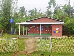
Anganwadi at Lampi.jpg
Anganwadi center at Lampi
India Assam location map.svg
Red pog.svg
Langpih
India location map.svg
Red pog.svg
Langpih
Coordinates: 25°50′10.65″N91°10′9.78″E / 25.8362917°N 91.1693833°E / 25.8362917; 91.1693833

Langpih, also spelt Langpi, Lampi, or Lumpi is a village in northeast India. [1] [2] [3] It is located near the border of West Khasi Hills district, Meghalaya and Kamrup district, Assam. [4] In Meghalaya's administrative structure, it is under Kyrdum gram panchayat, Mawshynrut block, West Khasi Hills district, whereas Assam assigns it to No. 9 Dakhin Pub Boko gram panchayat, Boko-Bongaon block, Kamrup district, with the Postal Index Number 781129 (shared with Hahimbazar, Nalapara, and Samuka, which are all in No. 70 Dakhin Pub Luki gram panchayat). [5] [6] [7]

Contents

Facilities

The village is served by a government health sub-centre, but it is not staffed by doctors. Teachers rarely come to the village's two schools. The village is not electrified. [3] The village is served by one road, in poor condition, connecting it to the Riangdo-Boko road which itself connects to National Highway 37 in Assam, at a junction just west of Boko. Another 5 kilometres (3.1 mi) road from neighbouring Kthiehthawiar to Meghalaya was under construction in 2008. [3] [8] That would connect Langpih through Kthiehthawiar to a junction with National Highway 44 just west of Nongstoin. It remained under construction by 2011. [9]

In 2008, the Assam government began building a health centre and police outpost in the village, and Assam police reportedly detained Meghalaya journalists who came to cover the event. [2] Meghalaya Deputy Chief Minister Hopingstone Lyngdoh stated that once the Kthiehthawiar–Meghalaya road was complete, the Meghalaya Police would move their temporary police outpost in the area from Lejadubi to Langpih. [8] He stated that two platoons of police would be stationed in the village. Assam Chief Secretary P. C. Sharma rebutted that his state would not allow this. [10]

Territorial dispute

1950s to 1990s

Langpih is the subject of a long-running dispute between the Meghalaya and Assam state governments, one of twelve such disputed territories. [8] According to Meghalaya Chief Minister Donkapur Roy, the British annexed the village to Assam's Kamrup district, but then after Indian independence, it was assigned to the United Khasi and Jaintia Hills district, a district in today's Meghalaya state. [4] The Meghalaya government claims that Assam's 1951 demarcation shows the area as part of a district in what would later become Meghalaya state. However, in 1972, Assam's new demarcation showed the area as part of its own Mikir Hills district (now Karbi Anglong District). [11]

In 1974, government forces from the two states had a faceoff in the village after Meghalaya policemen allegedly expelled Nepalese grazers, leading Assam policemen to arrive and investigate. [12] Link magazine described the situation as "explosive". [13] Hopingstone Lyngdoh claims that Assam "encroached on the village in 1979" and since then encouraged further Assamese settlement there. [10] In 1988, it was claimed in the Lok Sabha that the government of Meghalaya had proposed to set up an electoral constituency, 34-Nongstoin, which covered Kamphaduli, Hakumari, and Langpih. [1]

2010s

The Langpih Incident occurred on 14 May 2010, when clashes broke out between the Nepalese and tribal Khasi people, leading to shootings by police. [14] National media reported that four Khasi villagers died of the gunshot wounds: Columbus Hujon, Charles Lyngkhoi, Dennis Nonsiej, and Ekros Rani. Reports of the total number of injured varied between twelve and twenty-six. [15] [16] The governments of Assam and Meghalaya have each reported the death toll as two; even this death toll has become an object of political controversy, with authorities of each state moving the corpses around across state borders to manipulate the number. [3] A monument was constructed in memory of the dead villagers. [15]

Repercussions of the 2010 incident continued to be felt in 2012, when Pynskhemlang Nongshlong of neighbouring Rambrai village planned to lead a hunger strike in memory of the four slain men. [15] Nongshlong and thirteen fellow activists took to a stage constructed by local people specially for their fast. Two hours after the fast began, the Assistant District Commissioner of Kamrup and 150 police of Assam State arrived at the site. However, Langpih villagers formed a human chain to deny access to police. [17] By the eighth day, eight of the fasters had been retired to Shillong Civil Hospital due to ill health; Nongshlong and five others remained, but were clearly suffering from the effects of dehydration. [18] As the fast neared its second week, Meghalaya Chief Minister Mukul Sangma appealed to Delhi for assistance. [19]

Nongshlong declared an end to the fast on 13 July, giving the government a deadline of two months to fulfill a list of demands which the villagers would later announce. [20] [21] However, on 16 July Nongshlong and four women resumed their fast at Nongstoin. [22] Around the same time, the Meghalaya People’s Human Rights Council sent a delegation to the 20th Session of the United Nations Human Rights Council in Geneva, Switzerland. MPHRC General Secretary Dino Dympep met with UN Special Rapporteur James Anaya regarding the 2010 killings, following which Anaya sent a communique to the Government of India. However, by the following month the GOI had failed to respond. [23]
Related Research Articles

<span class="mw-page-title-main">Meghalaya</span> State in northeastern India

Meghalaya is a state in northeast India. Meghalaya was formed on 21 January 1972 by carving out two districts from the state of Assam: (a) the United Khasi Hills and Jaintia Hills and (b) the Garo Hills. The estimated population of Meghalaya in 2014 was 3,211,474. Meghalaya covers an area of approximately 22,429 square kilometres, with a length-to-breadth ratio of about 3:1.

<span class="mw-page-title-main">Shillong</span> City and state capital of Meghalaya, India

Shillong is a hill station and the capital of Meghalaya, a state in northeastern India. It is the headquarters of the East Khasi Hills district. Shillong is the 330th most populous city in India with a population of 143,229 according to the 2011 census. It is said that the rolling hills around the town reminded the British of Scotland. Hence, they would also refer to it as the "Scotland of the East".

<span class="mw-page-title-main">Ri-Bhoi district</span> District of Meghalaya in India

Ri Bhoi is an administrative district in the state of Meghalaya in India. The district headquarters are located at Nongpoh. The district occupies an area of 2378 km² and has a population of 258,840. As of 2011 it is the second least populous district of Meghalaya, after South Garo Hills.

<span class="mw-page-title-main">West Garo Hills district</span> District of Meghalaya in India

West Garo Hills is an administrative district in Garo Hills of the state of Meghalaya in India. Tura town is the administrative headquarters of the district. The district occupies an area of 3714 km². In 2011, its population was 643,291. As of 2011, it is the second most populous district of Meghalaya, after East Khasi Hills.

<span class="mw-page-title-main">West Khasi Hills district</span> District of Meghalaya in India

West Khasi Hills is an administrative district in the state of Meghalaya in India.

<span class="mw-page-title-main">Kamrup district</span> District of Assam in India

Kamrup Rural district, or simply Kamrup district, is an administrative district in the state of Assam in India formed by dividing the old Kamrup district into two in the year 2003; other being Kamrup Metropolitan district, named after the region it constitutes. This district, along with Nalbari, Barpeta, Kamrup Metropolitan, Bajali and Baksa districts has been created from the Undivided Kamrup district.

<span class="mw-page-title-main">Khasi Hills</span> Region in Meghalaya, India

The Khasi Hills are a low mountain formation on the Shillong Plateau in the Meghalaya state of India. The Khasi Hills are part of the Garo-Khasi-Jaintia range and connect with the Purvanchal Range and larger Patkai Range further east. The Khasi Hills, and the whole Garo-Khasi-Jaintia range, are in the Meghalaya subtropical forests ecoregion.

Shri Hoping Stone Lyngdoh was an Indian politician who was the president of the Hill State People's Democratic Party (HSPDP), one of three official political parties of the state of Meghalaya in India. He was the son of late Hajur Shon; was born at Nonglait Village, West Khasi Hills District on March 15, 1929; he studied at St. Anthony's College, Shillong.

Jorabat is a village, suburban fringe and a junction which covers area under both Ri-Bhoi district, Meghalaya, India and Kamrup Metropolitan district, Assam, India, with greater parts in Kamrup Metropolitan district of Assam and lesser southern parts in Ri-Bhoi district of Meghalaya.

<span class="mw-page-title-main">Khasi and Jaintia Hills</span> Mountainous region of northeastern India

The Khasi and Jaintia Hills are a mountainous region in India that was mainly part of Assam and Meghalaya. This area is now part of the present Indian constitutive state of Meghalaya, which includes the present districts of East Jaintia Hills district, headquarter Khliehriat, West Jaintia Hills district, headquarter Jowai, East Khasi Hills district, headquarter Shillong, and West Khasi Hills district, headquarter Nongstoin.

<span class="mw-page-title-main">Koch people</span> Ethnic group in India and Bangladesh

The Koch are a small trans-border ethnic group of Assam and Meghalaya in India and northern Bangladesh. The group consists of nine matrilineal and strictly exogamous clans, with some of them preserving a hitherto sparsely documented Boro-Garo language called Koch, whereas others have switched to local varieties of Indo-Aryan languages. It is a Scheduled Tribe in Meghalaya, India. Koches want to preserve language and culture and heritage.

Cherra Companyganj State Railways (CCSR) was a narrow gauge mountain railway that existed in British India.

Boko is a town located in Assam, in the Kamrup district in the Indian state of Assam. The town is composed of 139 villages. It is approximately 55 kilometers west of Guwahati.

<span class="mw-page-title-main">Lower Assam division</span> Division in Assam, India

Lower Assam division is one of the 5 administrative divisions of Assam in India. It was formed in 1874, consisting of the undivided Kamrup district of Western Assam, undivided Darrang and Nagaon districts of Central Assam and Khasi & Jaintia hills of Meghalaya, created for revenue purposes. The division is under the jurisdiction of a Commissioner, who is stationed at Guwahati. The division currently covers the Western Brahmaputa Valley. Shri Jayant Narlikar, IAS is the current Commissioner of Lower Assam division.

<span class="mw-page-title-main">Insurgency in Meghalaya</span>

The Insurgency in Meghalaya is a frozen armed conflict between India and a number of separatist rebel groups which was taking place in the state of Meghalaya. The Insurgency in Meghalaya is part of the wider Insurgency in Northeast India, and was fueled by demands of the Khasi, Synteng and Garo people for a separate state.

Nongstoin Legislative Assembly constituency is one of the 60 Legislative Assembly constituencies of Meghalaya state in India.

Discrimination against Bengalis in India comprises negative attitudes and views on Bengalis in India. Though Bengalis have lived in different parts of India for centuries, they are subject to widespread discrimination. This can be either by any other community or in any particular place, due to reasons like inhabitation, discriminating sentiments, political reasons, Government actions, anti-Bangladeshi sentiment etc. The discriminative condition of Bengalis can be traced from Khoirabari massacre, Nellie massacre, Silapathar massacre, North Kamrup massacre, Goreswar massacre, Bongal Kheda etc. This has led to emergence of Bengali sub-nationalism in India as a form of protest and formation of many pro-Bengali organisations in India.

<span class="mw-page-title-main">Eastern West Khasi Hills district</span> District in Meghalaya, India

Eastern West Khasi Hills is a district in the Indian state of Meghalaya, located approximately 25 kilometres (16 mi) west of the state capital of Shillong. It was created in 2021, after bifurcation of existing West Khasi Hills district. The territories which make up the district recorded a total population of 131,451 in the 2011 census. The district headquarters is the town of Mairang.

The Langpih Incident occurred on 14 May 2010, when clashes broke out between Nepalese Ghorka and Khasi people, leading to shootings by Assam Police.

References

  1. 1 2 Lok Sabha debates (English Version), Lok Sabha Secretariat, 1988, p. 97
  2. 1 2 "Assam conducts function on disputed land", The Hindu, Chennai, India, 31 May 2008, retrieved 10 August 2010
  3. 1 2 3 4 Roy, Dipankar; Sarma, Pankaj (16 May 2010), "Lampi: a victim of one-upmanship; Progress eludes 'apple of discord'", The Telegraph, Calcutta, India, archived from the original on 19 May 2010, retrieved 18 August 2010
  4. 1 2 "Don't politicise Langpih: Meghalaya", Daily News and Analysis, 3 June 2008, retrieved 10 August 2010
  5. "Kamrup", Name of Habitations in yearly status report, rural water supply programme, Department of Drinking Water and Sanitation, Government of India, 2010, retrieved 27 August 2010
  6. "West Khasi Hills" (PDF), List of Habitations that have been provided with Water Supply during the year 2007–2008, Public Health Engineering Department, Government of Meghalaya, 2008, retrieved 27 August 2010
  7. Pincode of Lower Lumpi, MapsOfIndia.com, retrieved 27 August 2010
  8. 1 2 3 "Meghalaya flexes muscle on Assam boundary", Zee News , 22 November 2008, archived from the original on 24 February 2014, retrieved 11 August 2012
  9. "La khang ia ki trok ban iaid na ka surok Kthiehthawiar-Langpih" (PDF), U Nongsain Hima, 9 July 2011, retrieved 11 August 2012[ permanent dead link ]
  10. 1 2 "Will set up police post in disputed Langpih village: Meghalaya", Indian Express, 22 November 2008, retrieved 10 August 2010
  11. "Won't accept 1972 demarcation by Assam: Meghalaya", The Times of India , 21 June 2010, archived from the original on 11 August 2011, retrieved 10 August 2010
  12. "Confrontation at Langpih", Data India, Press Institute of India, p. 63, 1974
  13. "The States", Link, vol. 16, no. 3, p. 28, 1974
  14. "Security tightened after clash at disputed village", Kolkata Observer, 15 May 2010, archived from the original on 13 July 2011, retrieved 10 August 2010
  15. 1 2 3 "Cops object to stage at Langpih", The Telegraph of India, Calcutta, India, 29 June 2012, archived from the original on 9 July 2012, retrieved 11 August 2012
  16. "Centre to probe firing across Assam-Meghalaya border", OneIndia.in, 19 May 2010, retrieved 10 August 2010
  17. "Assam Police Fails to Disrupt Langpih Fast", Northeast Today, 2 July 2012, archived from the original on 18 February 2013, retrieved 11 August 2012
  18. "Fast over Langpih enters Day Eight; No solution to imbroglio in sight", The Telegraph of India, Calcutta, India, 9 July 2012, archived from the original on 4 March 2016, retrieved 11 August 2012
  19. "Sangma petitions Delhi on Langpih". The Telegraph of India. Calcutta, India. 11 July 2012. Archived from the original on 17 July 2012. Retrieved 11 August 2012.
  20. "Hunger strike at Langpih to be withdrawn tomorrow", Business Standard, 13 July 2012, retrieved 11 August 2012
  21. "Langpih protesters end fast unto death", The Shillong Times, 13 July 2012, retrieved 11 August 2012
  22. "Youth resumes fast unto death at hospital". The Telegraph. Calcutta, India. 16 July 2012. Archived from the original on 22 August 2014. Retrieved 11 August 2012.
  23. "India yet to submit th elong pending Assam-Meghalaya Border dispute to the UN", TNT Magazine, 1 August 2012, retrieved 11 August 2012