Margate is a small seaside town on the Channel Highway between North-West Bay and the Snug Tiers, 7 kilometres (4 mi) south of Kingston in Tasmania, Australia. It is mostly in the Kingborough Council area, with about 4% in the Huon Valley Council LGA. Margate is also part of the Greater Hobart statistical area.
Goongerah is a community on the Brodribb River, located in Gippsland, Australia, near Mount Ellery. At the 2021 census, Goongerah had a population of 31.

Sorell is a town in Tasmania, Australia, north-east of Hobart. It is located on the Tasman Highway at the junction with the Arthur Highway. Sorell is one of Tasmania's oldest towns, being first settled in 1808 as a small farming community and becoming an official township in 1821. At the 2006 census, Sorell had a population of 1,546, and at the 2011 census, a population of 2,476. and at the 2016 census, a population of 2,907.
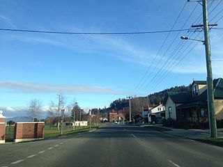
Scottsdale, formerly known as Ellesmere, is a town in the north-east of Tasmania, Australia. It lies on the Tasman Highway, around 63 kilometres (39 mi) north-east of Launceston and 22 km (14 mi) south-east of the coastal town of Bridport. It is part of the Dorset Council.

Somerset is a small township to the west of Burnie, Tasmania, Australia, which shares its name with the County of Somerset, England, UK. Today the city of Burnie encompasses the entire Burnie-Somerset urban area; however, the town is part of the Waratah/Wynyard municipal area.
Cressy is a small town 35 kilometres (22 mi) south-west of Launceston, Tasmania. It came into existence in the 1850s to service the surrounding wheat farms. At the 2006 census, Cressy had a population of 670. It is known as Tasmania's "Trout capital" for the good fishing in the area. It is also home to an extensive agriculture research facility for the Tasmanian Institute of Agricultural Research.

Oatlands is an important historical village on the shores of Lake Dulverton in the centre of Tasmania, Australia. Oatlands is located 84 km north of Hobart and 115 km south of Launceston on the Midland Highway. At the 2021 census, Oatlands had a population of 728.
Rossarden is a rural locality in the local government areas (LGA) of Northern Midlands (89%) and Break O'Day (11%) in the Central and North-east LGA regions of Tasmania. The locality is about 81 kilometres (50 mi) east of the town of Longford. The 2016 census recorded a population of 42 for the state suburb of Rossarden.
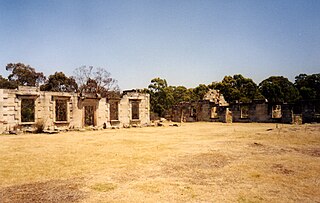
Saltwater River is a rural locality in the local government area (LGA) of Tasman in the South-east LGA region of Tasmania. The locality is about 14 kilometres (8.7 mi) north of the town of Nubeena. The 2016 census has a population of 123 for the state suburb of Saltwater River.

Woodbridge is a semi-rural locality in the local government area (LGA) of Kingborough in the Hobart LGA region of Tasmania. The locality is about 26 kilometres (16 mi) south of the town of Kingston. The 2021 Census recorded a population of 547 for the state suburb of Woodbridge, with the median age being 54. There are 180 families living in Woodbridge, with a mean of 1.8 children per household. It is located 38 kilometres (24 mi) south of the state capital, Hobart.

Hamilton is a rural locality in the local government area (LGA) of Central Highlands in the Central LGA region of Tasmania. The locality is about 73 kilometres (45 mi) north-west of the city of Hobart. The 2016 census recorded a population of 241 for the suburb of Hamilton.
South Arm is a rural residential locality in the local government area of Clarence in the Hobart region of Tasmania. The locality is about 32 kilometres (20 mi) south-east of the town of Rosny Park. The 2016 census has a population of 880 for the state suburb of South Arm.

Valley View is a suburb of Adelaide, South Australia. It spans three separate local government areas. They are the City of Salisbury, the City of Port Adelaide Enfield, and the City of Tea Tree Gully. The suburb's boundaries are defined by the intersection of Walkleys, Grand Junction and North East Roads in the south, and Wright and Kelly Roads in the north and east.
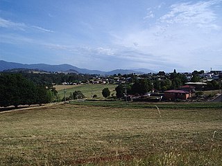
Franklin is a small township on the western side of the Huon River in the south-east of Tasmania, between Huonville and Geeveston. At the 2021 census, Franklin had a population of 444.
Ouse is a locality and small town in the Central Highlands Council local government area in Tasmania, Australia on the Lyell Highway. At the 2016 census, Ouse had a population of 303.

Fingal is a rural locality in the local government area (LGA) of Break O'Day in the North-east LGA region of Tasmania. The locality is about 56 kilometres (35 mi) south-west of the town of St Helens. The 2016 census recorded a population of 405 for the state suburb of Fingal.
Yolla is a rural community in north-western Tasmania, Australia. At the 2016 census, Yolla and the surrounding area had a population of 316. It is on the Murchison Highway about 20 kilometres (12 mi) south of the towns of Wynyard, Somerset and Burnie. The area around Yolla is used for dairying, beef cattle, growing vegetables, opium poppies and other crops, as well as forestry and mining. Local attractions are Hellyer Gorge and the Oldina Forest Reserve.
Murdunna is a rural locality in the local government area (LGA) of Tasman in the South-east LGA region of Tasmania. The locality is about 36 kilometres (22 mi) north-east of the town of Nubeena. The 2016 census recorded a population of 309 for the state suburb of Murdunna. It is a small town at the head of King George Sound, a narrow bay opening off Norfolk Bay. Murdunna is approximately halfway down the Forestier Peninsula on the Arthur Highway to Port Arthur. It is around 6 metres above sea level.

Coles Bay is an Australian town on the east Coast of Tasmania 192 km north-east of Hobart and 173 km south-east of Launceston, being the main entrance point for visitors to the Freycinet National Park.
Preolenna is a locality and small rural community of Waratah-Wynyard, Tasmania. It is located about 25 kilometres (16 mi) inland from the town of Wynyard. The 2011 census determined a population of 287 for the state suburb of Lapoinya, which the locality of Preolenna forms part of.
