
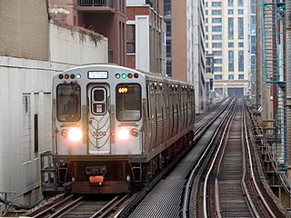
The Chicago "L" is the rapid transit system serving the city of Chicago and some of its surrounding suburbs in the U.S. state of Illinois. Operated by the Chicago Transit Authority (CTA), it is the fourth-largest rapid transit system in the United States in terms of total route length, at 102.8 miles (165.4 km) long as of 2014, and the third-busiest rapid transit system in the United States. In 2016, the "L" had 1,492 rail cars, eight different routes, and 145 train stations. In 2023, the system had 117,447,000 rides, or about 350,900 per weekday in the first quarter of 2024.

The Blue Line is a 26.93-mile-long (43.34 km) Chicago "L" line which extends through The Loop from O'Hare International Airport at the far northwest end of the city, through downtown via the Milwaukee–Dearborn subway and across the West Side to its southwest end at Forest Park, with a total of 33 stations. At about 27 miles, it is the longest line on the Chicago "L" system and second busiest, and one of the longest local subway/elevated lines in the world. It has an average of 64,978 passengers boarding each weekday in 2022.
The Green Line is a rapid transit line in Chicago, Illinois, operated by the Chicago Transit Authority (CTA) as part of the Chicago "L" system. It is the only completely elevated route in the "L" system. All other routes may have various combinations of elevated, subway, street level, or freeway median sections.

The Pink Line is an 11.2 mi (18.0 km) rapid transit line in Chicago, run by the Chicago Transit Authority (CTA) as part of the Chicago "L" system. It is the CTA's newest rail line and began operation for a 180-day trial period on June 25, 2006, running between 54th/Cermak station in Cicero, Illinois and the Loop in downtown Chicago. As the line enters downtown Chicago, it begins to share tracks with Green Line trains on Lake Street. This connection is handled by the previously non-revenue Paulina Connector set of tracks. In 2022, over 3 million passengers boarded Pink Line trains.
18th is an 'L' station on the CTA's Pink Line. It is located at 1710 West 18th Street in the Pilsen neighborhood of Chicago, Illinois. The station is decorated with colorful murals painted by local artists from Pilsen.

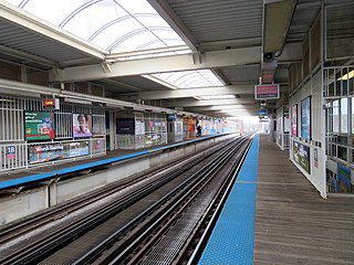
Racine is an 'L' station on the CTA's Blue Line. The station serves the Near West Side neighborhood and the western end of the UIC campus.

Pulaski is a station on the Chicago 'L' system, serving the Blue Line's Forest Park branch. The station is located in the median of the Eisenhower Expressway and serves the West Garfield Park neighborhood. A long ramp connects the platform to the station house on the Pulaski Road overpass. There was originally a similar entrance from the Keeler Avenue overpass; the entrance from Keeler was closed to cut costs on January 15, 1973, but retained as an exit, and the exit was fully closed on December 28, 1978. The structure for this exit still stands but it is closed to the public.

Damen is a station on the Chicago Transit Authority's 'L' system, serving the Pink Line and the Pilsen neighborhood.

54th/Cermak is an 'L' station and the terminus of the CTA's Pink Line. It was the terminus of the former Cermak branch of the Blue Line. It is located at Cermak Road between 54th and Laramie Avenues in Cicero, Illinois. It is the only terminal with only one track used for service. Trains board on the eastern half of 54th/Cermak station and unload on the western half. Previously known as the Cicero-Berwyn Terminal, it is located about 1 mile (1.6 km) from the city of Berwyn. Tracks continue westward to the 54th Yard, the maintenance and storage yard for Pink Line trains.

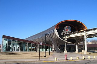
Cermak–McCormick Place is a "L" station on the CTA's Green Line. The station, designed by Chicago-based Ross Barney Architects and engineered by Primary Consultant T.Y. Lin International, is located at Cermak Road and State Street on the Near South Side of Chicago. The station includes three entrances – one on each side of Cermak Road and one at 23rd Street. The main station entrance is built on the north side of Cermak road.

The Metropolitan main line was a rapid transit line of the Chicago "L" system from 1895 to 1958. It ran west from downtown to a junction at Marshfield station. At this point the Garfield Park branch continued westward, while the Douglas Park branch turned south, and the Logan Square branch turned north with the Humboldt Park branch branching from it. In addition to serving the Chicago "L", its tracks and those of the Garfield Park branch also carried the Chicago Aurora and Elgin Railroad, an interurban that served Chicago's western suburbs, between 1905 and 1953.
The South Side Elevated is a branch of the Chicago "L" system in Chicago, Illinois that is served by the Green Line. It has on average 12,509 passengers, counting branch divisions, boarding each weekday as of February 2013, according to the Chicago Transit Authority. The branch is 6.5 miles (10.5 km) long with a total of 8 stations, and runs from the Near South Side to the Washington Park neighborhood of Chicago.

The Lake Street Elevated, also known as the Lake branch, is a 8.75 mi (14.08 km) long branch of the Chicago "L" which is located west of the Chicago Loop and serves the Green Line for its entire length, as well as the Pink Line east of Ashland Avenue. As of February 2013, the branch serves an average of 27,217 passengers each weekday. It serves the Near West Side, East Garfield Park, West Garfield Park, and Austin neighborhoods of Chicago, as well as the suburbs Oak Park and Forest Park. It owes its name to Lake Street, the street that the branch overlooks for 6.25 mi (10.06 km) before continuing its route straight west, adjacent to South Boulevard, towards the terminus at Harlem/Lake.

The Cermak branch, formerly known as the Douglas branch, is a 6.6 mi (10.6 km) long section of the Pink Line of the Chicago "L" system in Chicago, Illinois. It was built by the Metropolitan West Side Elevated west of the Loop. As of February 2013, it serves an average of 17,474 passengers every weekday. The branch serves the Near West Side, Pilsen, Lower West Side, South Lawndale, and North Lawndale neighborhoods of Chicago, and the west suburb Cicero, Illinois. The branch operates from 4:05 a.m. to 1:25 a.m., weekdays, and Saturdays from 5:05 a.m. to 1:25 a.m., and Sundays from 5:00 a.m. to 1:25 a.m., including holidays.
The Garfield Park Branch was a rapid transit line which was part of the Chicago "L" system from 1895 to 1958. The branch served Chicago's Near West Side, East Garfield Park, West Garfield Park, and Austin neighborhoods, and the suburbs of Oak Park, and Forest Park, and consisted of twenty-two stations. It opened on June 19, 1895 and closed on June 22, 1958, when it was replaced by the Congress branch of the Blue Line.

The Logan Square branch was an elevated rapid transit line of the Chicago "L", where it was one of the branches of the Metropolitan West Side Elevated Railroad. Diverging north from the Metropolitan's main line west of Marshfield station, it opened in 1895 and served Chicago's Logan Square and West Town neighborhoods. North of Damen station, the Humboldt Park branch diverged from the Logan Square branch, going west to serve Humboldt Park. The original Logan Square branch was separated into several sections in 1951, some of which remain in revenue service as of 2023.
Loomis Street is a north–south street in Chicago that is 1400 W in Chicago's grid system, making it 1.75 miles (2.82 km) west of the north–south baseline of State Street. It runs from the Chicago and Northwestern Railway tracks south, with interruptions, to Center Avenue in the suburb of Homewood. Between the railway tracks and the north branch of the Chicago River it is known as Noble Street and north of the River's north branch it is known as Southport Avenue. As Southport Avenue it goes up north to its intersection with Clark Street just south of Berteau. The street continues again at Argyle Street until Touhy Avenue as Glenwood Avenue.

Marshfield was a rapid transit station on the Chicago "L" in service between 1895 and 1954. Constructed by the Metropolitan West Side Elevated Railroad, it was the westernmost station of the Metropolitan's main line, which then diverged into three branches. Marshfield was also served by the Aurora Elgin and Chicago Railway (AE&C) and its descendant the Chicago Aurora and Elgin Railroad (CA&E), an interurban, between 1905 and 1953.

Oak Park was a rapid transit station on the Chicago "L", where it was the westernmost extension of the Douglas Park branch in the suburb of Berwyn, from 1924 to 1952. Although the branch had originally been constructed starting from 1896 by the Metropolitan West Side Elevated Railroad Company, it did not reach Oak Park until March 16, 1924, by which time the Metropolitan had been subsumed by the Chicago Rapid Transit Company (CRT). Plans to extend the branch as far west as Harlem Avenue were made by the Metropolitan but were never done as development never justified it.


