
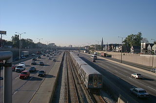
The Chicago "L" is the rapid transit system serving the city of Chicago and some of its surrounding suburbs in the U.S. state of Illinois. Operated by the Chicago Transit Authority (CTA), it is the fourth-largest rapid transit system in the United States in terms of total route length, at 102.8 miles (165.4 km) long as of 2014, and the second busiest rapid transit system in the United States, after the New York City Subway. In 2016, the "L" had 1,492 rail cars, eight different routes, and 145 train stations. In 2022, the system had 103,524,900 rides, or about 334,200 per weekday in the fourth quarter of 2022.

The Chicago Transit Authority (CTA) is the operator of mass transit in Chicago, Illinois, United States, and some of its surrounding suburbs, including the trains of the Chicago "L" and CTA bus service. In 2022, the system had a ridership of 243,538,700, or about 800,600 per weekday as of the fourth quarter of 2022.

The Blue Line is a 26.93-mile-long (43.34 km) Chicago "L" line which extends through The Loop from O'Hare International Airport at the far northwest end of the city, through downtown via the Milwaukee–Dearborn subway and across the West Side to its southwest end at Forest Park, with a total of 33 stations. At about 27 miles, it is the longest line on the Chicago "L" system and second busiest, and one of the longest local subway/elevated lines in the world. It has an average of 47,120 passengers boarding each weekday in 2021.

The Green Line is a rapid transit line on the Chicago Transit Authority's "L" system. It is the only completely elevated route in the "L" system. All other routes may have various combinations of elevated, subway, street level, or freeway median sections.
East Garfield Park is on the West Side of Chicago, Illinois, west of the Loop.

Thorndale is an 'L' station on the CTA's Red Line. It is located at 1118 West Thorndale Avenue in the Edgewater neighborhood of Chicago, Illinois. The adjacent stations are Granville, located about one quarter mile to the north, and Bryn Mawr, about one half mile to the south. Four tracks pass through the station, but there is only a single island platform in the center of the tracks; Purple Line weekday rush hour express service use the outside tracks but do not stop at this station.

Kedzie is a Metra commuter railroad station in the East Garfield Park neighborhood on the West Side of Chicago. It is served by the Union Pacific West Line.

Garfield is an "L" station on the CTA's Green Line. It is situated at 320 E. Garfield Boulevard in the Washington Park neighborhood. It opened on October 12, 1892. This station is the southernmost Green Line station served by both of the Green Line's branches: south of Garfield, the Green Line splits into two branches, one terminating at Ashland/63rd, and one at Cottage Grove.

Kedzie is a station on the Chicago Transit Authority's 'L' system, serving the Green Line and the East Garfield Park neighborhood. It opened in March 1894, and is three blocks south of Metra's Kedzie station on the Union Pacific/West Line. It is also near the Chicago Center for Green Technology.

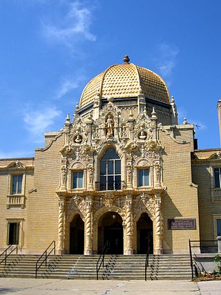
Conservatory–Central Park Drive is a station on the Chicago Transit Authority's 'L' system, serving the Green Line. The station opened on June 30, 2001. It is located in the East Garfield Park neighborhood and named for the Garfield Park Conservatory just outside the station.

Pulaski is a station on the Chicago Transit Authority's 'L' system, serving the Green Line. Pulaski is located at the intersection of Lake Street and Pulaski Road in the West Garfield Park neighborhood of Chicago, Illinois. The station opened in March 1894.

Pulaski is an 'L' station on the CTA's Orange Line, which runs between Midway Airport and The Loop; it is situated between Midway and Kedzie stations. Pulaski is located at Pulaski Road and 51st Street on the Southwest Side of Chicago, Illinois. The station is within the Archer Heights neighborhood, which is both residential and commercial, and the station itself is in a commercial district on Pulaski Road. Pulaski opened on October 31, 1993, the opening date of the Orange Line.

California is a station on the Chicago Transit Authority's 'L' system, serving the Blue Line, From California, trains run every 2–7 minutes during rush-hour periods, and take 12 minutes to reach the Loop.

Kedzie–Homan is an 'L' station on the CTA Blue Line's Forest Park branch. The station is located in the median of the Eisenhower Expressway and serving the East Garfield Park neighborhood and has two entrances on the Kedzie and Homan Avenue overpasses.

The Metropolitan main line was a rapid transit line of the Chicago "L" system from 1895 to 1958. It ran west from downtown to a junction at Marshfield station. At this point the Garfield Park branch continued westward, while the Douglas Park branch turned south, and the Logan Square branch turned north with the Humboldt Park branch branching from it. In addition to serving the Chicago "L", its tracks and those of the Garfield Park branch also carried the Chicago Aurora and Elgin Railroad, an interurban that served Chicago's western suburbs, between 1905 and 1953.
The Dan Ryan branch is a 9.4 mi (15.1 km) long section of the Chicago "L" system located on the South Side of Chicago, Illinois. It is operated by the Chicago Transit Authority, as part of its Red Line service and is normally through-routed downtown towards the North Side via the State Street subway. As of February 2013, the branch serves 45,355 passengers per weekday. As part of the CTA's busiest rapid transit line, it is operated 24 hours a day, 365 days a year. The branch serves the Chinatown, Armour Square, Fuller Park, Englewood, Greater Grand Crossing, Chatham and Roseland neighborhoods.

The Lake Street Elevated, also known as the Lake branch, is a 8.75 mi (14.08 km) long branch of the Chicago "L" which is located west of the Chicago Loop and serves the Green Line for its entire length, as well as the Pink Line east of Ashland Avenue. As of February 2013, the branch serves an average of 27,217 passengers each weekday. It serves the Near West Side, East Garfield Park, West Garfield Park, and Austin neighborhoods of Chicago, as well as the suburbs Oak Park and Forest Park. It owes its name to Lake Street, the street that the branch overlooks for 6.25 mi (10.06 km) before continuing its route straight west, adjacent to South Boulevard, towards the terminus at Harlem/Lake.

The Cermak branch, formerly known as the Douglas branch, is a 6.6 mi (10.6 km) long section of the Pink Line of the Chicago "L" system in Chicago, Illinois. It was built by the Metropolitan West Side Elevated west of the Loop. As of February 2013, it serves an average of 17,474 passengers every weekday. The branch serves the Near West Side, Pilsen, Lower West Side, South Lawndale, and North Lawndale neighborhoods of Chicago, and the west suburb Cicero, Illinois. The branch operates from 4:05 a.m. to 1:25 a.m., weekdays, and Saturdays from 5:05 a.m. to 1:25 a.m., and Sundays from 5:00 a.m. to 1:25 a.m., including holidays.
Kedzie was a rapid transit station on the Chicago "L", serving the Garfield Park branch of its Metropolitan West Side Elevated Railroad, from 1895 to 1958. Between 1905 and 1953, it also served the Chicago Aurora and Elgin Railroad (CA&E), an interurban using Garfield Park tracks, between 1905 and 1953.

