Larciano

Last updated
Larciano
Comune di Larciano
Larciano Castello.JPG
Larciano-Stemma.png
Location of Larciano
Larciano
Italy provincial location map 2016.svg
Red pog.svg
Larciano
Location of Larciano in Italy
Italy Tuscany location map.svg
Red pog.svg
Larciano
Larciano (Tuscany)
Coordinates: 43°49′N10°53′E / 43.817°N 10.883°E / 43.817; 10.883
Country Italy
Region Tuscany
Province Pistoia (PT)
Frazioni Castelmartini, Cecina, Larciano Castello, San Rocco
Government
  MayorLisa Amidei
Area
[1]
  Total24.97 km2 (9.64 sq mi)
Elevation
50 m (160 ft)
Population
 (31 August 2017 [2] ) [3]
  Total6,319
  Density250/km2 (660/sq mi)
Demonym Larcianesi
Time zone UTC+1 (CET)
  Summer (DST) UTC+2 (CEST)
Postal code
51036
Dialing code 0573
Website Official website

Larciano is a comune (municipality) in the Province of Pistoia in the Italian region of Tuscany. The town hall is located in San Rocco.

Contents

Larciano is about 50 kilometers west of Florence and about 15 kilometers south of Pistoia.

Larciano borders the following municipalities: Cerreto Guidi (FI), Fucecchio (FI), Lamporecchio (PT), Monsummano Terme (PT), Ponte Buggianese (PT), Serravalle Pistoiese (PT).

Geography

Territory

Larciano is located in the Valdinievole area, on the Montalbano slopes and it borders the Fucecchio Marsh.

History

The name of Larciano results from the latinization of the Etruscan name Larthial, which was the possessive genitive of the male name Larth. Larth is the proper name of an Etruscan fighter whose tomb, dating back to the year 340 before Christ, was discovered in 1870 in Tarquinia (a municipality in the Lazio region, Italy). In 941 the toponym was presented as Arsianus; as time passed, it was converted into its current name. Another hypothesis focuses on a "praedium" (farm), probably donated to a Roman soldier who had fought in the wars against the Ligurians and who stood out for his courage. It must be pointed out that the Italian ending of words in "ano" is typical of the Roman settlements which arose from a "praedium". Finally, a third hypothesis, even if it appears to be the least probable, states that the toponym derives from "larch" since in the past the area was rich in larch woods.

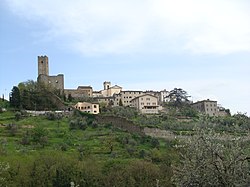
The history of Larciano is based on the history of the area named nowadays Larciano Castello.

By the middle of the tenth century, Larciano belonged to the Guidis thanks to a donation that Ranieri and Guido, Count Tegrimo's sons, made to the cathedral and to the bishop of Pistoia. Later, the castle situated in Larciano was confirmed to the Guidis by Arrigo VI and Federico II.

In 1225 the sons of Guido Guerra, who was the count of Modigliana (a municipality in the Emilia-Romagna region, Italy), sold Larciano, along with Cecina, Casi and Collecchio, to the municipality of Pistoia for 6,000 lire. Due to its position, Larciano became one of the cornerstones of the defensive system of Pistoia in the so-called “low part of the mountains”. In fact, this denomination used to be referred to the western slope of the Montalbano area: this explains the decision of the city to strengthen its walls and other defense works. In 1302, during the war between the Ghibellines coming from Pistoia against the Guelphs from Florence and Lucca, Larciano was conquered immediately after the surrender of Serravalle. However, in 1310 the town was reconquered together with other territories lost by Pistoia, upon the payment of 10,000 gold florins. Around the year 1391, the castle became a solid base organized by Pistoia and Florence, with the same purpose of protecting themselves by the danger of a possible offensive in Tuscany by Gian Galeazzo Visconti.

In 1401 Florence took possession of Larciano and the whole countryside; consequently Larciano became the seat of one of the four Podestà’s seat in which the territory around Pistoia was organized. Among the Podestà, the most famous was Francesco Ferrucci. Subsequently, Larciano and Serravalle were put together in the same Podestà for the will of the Medici family. In 1772 Serravalle became the sole seat of the Podestà’s seat, while in 1774 Larciano and Lamporecchio were gathered.

It was only on the 1st of July 1897 that Larciano obtained the separation from Lamporecchio and it became an independent municipality. It was composed of the hamlets of Biagiotti, Biccimurri, Castelmartini, Cecina, Larciano Castello and San Rocco, which still houses the Town Hall.

Honours

Merito civile gold medal BAR.svg 
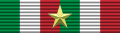
Italian gold medal bar

"During the last world conflict, this municipality of approximately five thousand two hundred inhabitants suffered one of the most brutal and atrocious retaliation by the Nazis troops, who slaughtered one hundred and seventy-five unarmed citizens, above all women, young people and children. Guided by a deep faith in a better, free and democratic country, the locals participated in the struggle against Nazi-fascism, giving a great example of exceptional self-denial, firmness and patriotism."

– 23 August 1944

Monuments and places of interest

Religious buildings

Civil buildings

Military buildings

Natural areas

Other

Marzocco Larciano (PT).jpg

Culture

Library

In Larciano there is a municipal library which offers many services, such as the local, the interlibrary and the home loan, the consultation, some educational activities for adults and children and activities to promote reading and a playroom. [7]

Research

Schools

In the municipality of Larciano it is possible to find two public kindergartens, a primary school and a middle school; the Istituto Comprensivo di Larciano includes all these schools.

Museums

Events

Human geography

Hamlets

Larciano is composed of four hamlets: Castelmartini, Cecina, Larciano Castello and San Rocco.

Castelmartini

It is a residential area characterized by a strong productive component. The original inhabited center, dating back to the end of the thirteenth century when a "castrum Martini Jacobi Admannati" is mentioned in the Liber censuum, is located west of via Francesca; in the same area there was the ancient hospital of San Donnino in Cerbaia, which has now disappeared and it is remembered through the name of the current church of Castelmartini. The ancient hospital was located not far from the place where Pistoia had a port which connected it with Pisa, through the canals of the marshes. Besides, this ancient hospital was connected to a road of considerable importance that crossed the Montalbano area, thus it was an important accommodation facility in the organization of the territory under the government of the Pistoian municipality. The Parish Church of Castelmartini, built as a chapel around 1200, underwent a radical makeover at the end of the nineteenth century, resulting in a late neoclassical aspect. In the building next to the church, the headquarters of the Centre for Research, Documentation and Promotion of the Fucecchio Marsh is located. Its purpose is to promote initiatives aimed to the conservation and enhancement of the marsh from an environmental and naturalistic point of view, in terms of an area of national and international interest. Proceeding towards the Morette Port, which is a particularly interesting area of access to the marsh, the Villa Poggi Banchieri is situated; it was built by expanding and modifying the ancient Castrum Martini which gave its name to this place.

Cecina, on the background Montevettolini. Cecina di larciano, veduta, sullo sfondo montevettolini 03.JPG
Cecina, on the background Montevettolini.

Cecina

It is a medieval village with walls and two entrance gates, located on the slopes of Montalbano; its origins are probably Etruscan and perhaps its name derives from the surname of the ancient Etruscan noble family of Volterra Kaiknas (in Latin Caecina). Within the walls there is the church of San Nicola, whose origins are Romanesque; the external hemicycle of the apse is preserved even if the entire structure has been radically remodelled over the centuries. The interior presents a vaulted roof and a single nave, along with the chapel of San Rosario situated on the left, whose altar dated to1632. In the second bay on the left, within a seventeenth-century frame, an expressive fourteenth century wooden crucifix is exhibited.

Larciano Castello

It has preserved the urban structure of a medieval village, developed on a sloping terrain, and it keeps the walls of the twelfth century with three entrance gates. The fortress is located at the highest point within the walls. The most important element of the fortress is the high quadrangular tower, from which you can observe a suggestive panorama that ranges from the Valdinievole area to the Lower Valdarno. Inside the fortress there is also a civic museum. The parish church of San Silvestro is characterized by a very simple plan with a single nave. Of medieval origin, this parish church does not provide many traces in the external walls and it has suffered radical transformations over the centuries. The rectory (the former Palazzo Podestarile) is a simple and massive building that looks out on the square, situated on the right of the church. At the centre of the square there is a column supporting the Marzocco, a reminder of the Florentine domination.

San Rocco

At the end of the nineteenth century, the population, that had settled inside the church of San Rocco since the seventeenth century, had grown considerably. In fact, a great number of people had moved from Larciano Castello to the flat areas, that had been reclaimed, so consequently, free from malaria and arable. The population commissioned the church in the place where there was already a small church dedicated to the Holy Virgin in 1631 when the plague, which had affected the territory of Larciano, was coming to an end and this building was dedicated to the saint considered the protector against evil.

The Town Hall in the main square of San Rocco. Municipio Larciano.JPG
The Town Hall in the main square of San Rocco.

In 1884 San Rocco was detached from San Silvestro from which it used to depend, and three years later it was recognized as a parish. This event marked the beginning and the subsequent development of the town of San Rocco, different from Larciano Alto. In 1897 Larciano obtained the administrative autonomy from Lamporecchio and the centre of San Rocco obtained the seat of the Town Hall, restored and inaugurated in June 1997.

Other localities in the territory

In Larciano there are other smaller localities, such as Baccane, Biagiotti, Biccimurri, Case di Monte, Colonna, Mungherino and Puntoni.

Media

Newspapers

Orizzonti is a cultural, informative and historical monthly magazine that deals with topics related to the municipalities of Larciano, Lamporecchio, Vinci and Cerreto Guidi; in the last years, articles related to Valdinievole area and Empoli are also inserted. The principal aim is to promote the socio-cultural activities linked to these territories; for this reason, readers are active users in the construction of this magazine, since they are invited to show any issues, proposals and suggestions, as well as they can write any articles having to do with topics of public interest.

Administration

A table with the different administrations of the municipality of Larciano is shown below.

PeriodNamePolitical partyPolitical postNote
17 July 198531 May 1990Graziano LustriPartito Comunista ItalianoMayor [10]
31 May 199022 April 1991Graziano LustriPartito Comunista ItalianoMayor [10]
22 April 199124 April 1995Andrea Stefano LolliniPartito Democratico della SinistraMayor [10]
24 April 199514 June 1999Andrea Stefano LolliniPartito Democratico della SinistraMayor [10]
14 June 199914 June 2004Roberta BenefortiCentro-SinistraMayor [10]
14 June 20048 June 2009Roberta BenefortiCentro-SinistraMayor [10]
8 June 200926 May 2014Antonio PappalardoLista CivicaMayor [10]
26 May 20144 March 2015Antonio PappalardoLista CivicaMayor [10]
4 March 20155 June 2016Lisa AmideiLista CivicaDeputy Mayor acting as Mayor [10]
5 June 2016In chargeLisa AmideiLista CivicaMayor [10]

Twin towns

Sport

Football

Larciano has several football clubs, among which the most important is the U.S.D. Art. Ind. Larcianese, showing the expression of the community of artisans, industrialists and citizens of Larciano. Recently, the Larcianese football club has achieved unexpected goals for a little village such as Larciano: it won the Italy Amateur Cup in 1998 and it had been playing in D-Series for several years.

The tournament of the districts

The tournament of the districts is an amateur football event that generally takes place during summer and a large part of the residents of Larciano are actively engaged. The current form of the tournament presents six districts competing with each other:

·      District of San Rocco

·      District of Cecina Ponente

·      District of Biccimurri

·      District of Colonna

·      District of Levante

·      District of Larciano

Two rounds of three districts each are drawn lots. The finalists of the previous edition's tournament are placed as seeded in the two rounds. The teams of each round face each other in a single match; the winner of each round goes directly to the semifinals, while the second and third teams will participate in a play-off.

Cycling

The Larcianese U.C. association embodies the passion of residents for cycling. It organizes the GP Industria & Artigianato di Larciano, a cycling race for professionals that generally takes place at the beginning of March, between the Strade Bianche and the Tirreno-Adriatico.

The Larcianese cycling association was born thanks to Nello Bonfanti, who was the representative of the Salvarani cycling team. Founded the association, Bonfanti became involved in organizing cycling races; so, starting from the early 60s the tradition of the cycling race named "I circuiti degli assi" began in Larciano and it continued until the mid-70s.

This cycling association was recognized nationally and then internationally.

Related Research Articles

<span class="mw-page-title-main">Città di Castello</span> Comune in Umbria, Italy

Città di Castello ; "Castle Town") is a city and comune in the province of Perugia, in the northern part of Umbria. It is situated on a slope of the Apennines, on the flood plain along the upper part of the river Tiber. The city is 56 km (35 mi) north of Perugia and 104 km (65 mi) south of Cesena on the motorway SS 3 bis. It is connected by the SS 73 with Arezzo and the A1 highway, situated 38 km (23 mi) west. The comune of Città di Castello has an exclave named Monte Ruperto within Marche.

<span class="mw-page-title-main">Arno (department)</span>

Arno was a department of the First French Empire in present-day Italy. It was named after the Arno river. It was formed in 1808, when the Kingdom of Etruria was annexed directly to France. Its capital was Florence.

<span class="mw-page-title-main">Province of Pisa</span> Province of Italy

The province of Pisa is a province in the Tuscany region of central Italy. Its capital is the city of Pisa. With an area of 2,448 square kilometres (945 sq mi) and a total population of 421,642, it is the second most populous and fifth largest province of Tuscany. It is subdivided into 37 comuni.

Serravalle may refer to:

<span class="mw-page-title-main">Serravalle (San Marino)</span> Castello in San Marino

Serravalle is a castello in northern San Marino. With a population of 10,878 inhabitants and an area of 10.53 km2, it is not only the most densely populated municipality in San Marino, but it also contains its largest settlement (Dogana). Serravalle is located on the edge of the Apennine Mountains.

<span class="mw-page-title-main">Montecatini Terme</span> Municipality in Tuscany, Italy

Montecatini Terme is an Italian municipality (comune) of c. 20,000 inhabitants in the province of Pistoia, Tuscany, central Italy. It is the most important center in Valdinievole. The town is located at the eastern end of Piana di Lucca and has a strong tourism industry, as well as industrial and commercial industries related to the spa, which in turn has increased the interest for hotel accommodation in the region.

<span class="mw-page-title-main">Poggibonsi</span> Comune in Tuscany, Italy

Poggibonsi is a town in the province of Siena, Tuscany, central Italy. It is located on the river Elsa and is the main centre of the Valdelsa Valley.

<span class="mw-page-title-main">Monsummano Terme</span> Comune in Tuscany, Italy

Monsummano Terme is an comune located in the Province of Pistoia, Tuscany, central Italy. It is located in the Valdinievole, and is a popular spa resort.

<span class="mw-page-title-main">Monteveglio</span> Frazione in Emilia-Romagna, Italy

Monteveglio is a frazione (village) in the comune (municipality) of Valsamoggia. It is located about 20 kilometres (12 mi) west of Bologna, near the Samoggia River, in the Italian region of Emilia-Romagna. It was an independent comune until 2014, when it merged with the neighboring municipalities of Bazzano, Valsamoggia, Castello di Serravalle, Crespellano, and Savigno. Monteveglio's main attractions are its pieve of Santa Maria and Oratory of San Rocco.

<span class="mw-page-title-main">Lamporecchio</span> Comune in Tuscany, Italy

Lamporecchio is a comune (municipality) in the Province of Pistoia in the Italian region Tuscany, located about 30 kilometres (19 mi) west of Florence and about 13 kilometres (8 mi) south of Pistoia, 15 kilometres (9 mi) east of Montecatini Terme, and 4 kilometres (2.5 mi) west of Vinci.

<span class="mw-page-title-main">Serravalle Pistoiese</span> Comune in Tuscany, Italy

Serravalle Pistoiese is a comune (municipality) in the Province of Pistoia in the Italian region Tuscany, located about 35 kilometres (22 mi) northwest of Florence and about 8 kilometres (5 mi) southwest of Pistoia.

<span class="mw-page-title-main">Cerreto Guidi</span> Comune in Tuscany, Italy

Cerreto Guidi is a comune (municipality) in the Metropolitan City of Florence in the Italian region Tuscany, located about 30 kilometres (19 mi) west of Florence.

<span class="mw-page-title-main">Buonconvento</span> Comune in Tuscany, Italy

Buonconvento is a comune (municipality) in the Province of Siena in the Italian region Tuscany, located about 70 kilometres (43 mi) south of Florence and about 25 kilometres (16 mi) southeast of Siena in the area known as the Crete Senesi.

<span class="mw-page-title-main">Santa Fiora</span> Comune in Tuscany, Italy

Santa Fiora is a comune (municipality) in the Province of Grosseto, in the Italian region of Tuscany, located about 110 kilometres southeast of Florence and about 40 km (25 mi) east of Grosseto. Santa Fiora borders the following municipalities: Abbadia San Salvatore, Arcidosso, Castel del Piano, Castell'Azzara, Piancastagnaio, Roccalbegna, Semproniano.

<span class="mw-page-title-main">Valdinievole</span> Area in Tuscany, Italy

Valdinievole or Val di Nievole is an area in the south-western part of the province of Pistoia, Tuscany, Italy.

Stigliano, Sovicille Frazione in Tuscany, Italy

Stigliano is a village in Tuscany, Italy, a frazione (subdivision) of the comune of Sovicille, in the province of Siena.

<span class="mw-page-title-main">Giuncarico</span> Frazione in Tuscany, Italy

Giuncarico is a village in Tuscany, central Italy, administratively a frazione of the comune of Gavorrano, province of Grosseto. At the time of the 2001 census its population amounted to 399.

Colle di Buggiano is a little medieval village in the Valdinievole. It is a frazione of the comune of Buggiano, in the province of Pistoia, Italy.

<span class="mw-page-title-main">Giovanni Francesco Guidi di Bagno</span>

Giovanni Francesco Guidi di Bagno (1578–1641) was an Italian cardinal, brother of cardinal Nicola Guidi di Bagno and nephew of cardinal Girolamo Colonna.

<span class="mw-page-title-main">Parish Church of San Silvestro</span>

The Parish Church of San Silvestro is a parish church dedicated to Saint Sylvester located in the municipality of Larciano, in the province of Pistoia, in Tuscany, Italy.

References

  1. "Superficie di Comuni Province e Regioni italiane al 9 ottobre 2011". Italian National Institute of Statistics. Retrieved 16 March 2019.
  2. It was home to Ilio Monti. All demographics and other statistics: Italian statistical institute Istat.
  3. "Popolazione Residente al 1° Gennaio 2018". Italian National Institute of Statistics. Retrieved 16 March 2019.
  4. "Giardino della Memoria" (in Italian).
  5. "Il Marzocco" (in Italian).
  6. Santoli, Quinto. Il Liber Censuum del Comunis Pistorii. Pistoia: Società Pistoiese di Storia Patria. p. 495.
  7. "Biblioteca comunale di Larciano" (in Italian).
  8. "Museo Della Civiltà Contadina Casa Dei" (in Italian).
  9. Pieri Enrico, Manfredini Roggero (2010). Guide to the Larciano city museum. Italy. p. 15.
  10. 1 2 3 4 5 6 7 8 9 10 "Anagrafe degli Amministratori Locali e Regionali" . Retrieved 3 December 2020.

Further reading