Prydz Bay is a deep embayment of Antarctica between the Lars Christensen Coast and Ingrid Christensen Coast. The Bay is at the downstream end of a giant glacial drainage systems that originates in the East Antarctic interior. The Lambert Glacier flows from Lambert Graben into the Amery Ice Shelf on the south-west side of Prydz Bay. Other major glaciers drain into the southern end of the Amery Ice Shelf at 73° S where the marine part of the system starts at the modern grounding zone.

The Ingrid Christensen Coast is that portion of the coast of Antarctica lying between Jennings Promontory, in 72°33′E, and the western end of the West Ice Shelf in 81°24′E. It is located in the western half of Princess Elizabeth Land, just east of the Amery Ice Shelf.

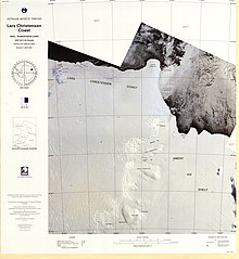
Polar Times Glacier is a glacier on Ingrid Christensen Coast, flowing northward between Svarthausen Nunatak and Boyd Nunatak into the western part of Publications Ice Shelf. It was delineated by John H. Roscoe from aerial photographs taken by USN Operation Highjump, 1946-1947, and named by Roscoe after The Polar Times, a polar journal published by the American Polar Society, New York City.
The Leopold and Astrid Coast is that portion of the coast of Antarctica lying between the western extremity of the West Ice Shelf, at 81°24′E, and Cape Penck, at 87°43′E. It is located in the eastern half of Princess Elizabeth Land. It was discovered and explored in an airplane flight from the Norwegian ship Thorshavn on January 17, 1934, by Lieutenant Alf Gunnestad and Captain Nils Larsen. The coast was named by Lars Christensen, Norwegian whaling magnate and leader of the expedition, for King Leopold and Queen Astrid of Belgium.
The Mawson Coast is that portion of the coast of Mac. Robertson Land, Antarctica, lying between William Scoresby Bay, at 59°34′E, and Murray Monolith, at 66°54′E. The coast was sighted during the British Australian New Zealand Antarctic Research Expedition (BANZARE), 1929–30, under Sir Douglas Mawson. Further exploration and landings at Cape Bruce and Scullin Monolith were made during BANZARE, 1930–31. Mawson Coast was named by the Antarctic Names Committee of Australia after Mawson in recognition of his great contribution to Antarctic exploration.

The Framnes Mountains are an Antarctic mountain range consisting of Casey Range, Masson Range, David Range, and Brown Range, and adjacent peaks and mountains. The three major ranges and other lesser features were sighted and named in February 1931 by the British Australian New Zealand Antarctic Research Expedition under Douglas Mawson. This coast was also sighted by Norwegian whalers in the same season. The whole area was mapped in detail by Norwegian cartographers from aerial photographs taken by the Lars Christensen Expedition in January 1937. This overall name for the several ranges was given by Lars Christensen after Framnesfjellet, a hill near Sandefjord, Norway.
Seaton Glacier is a glacier 17 miles (27 km) long, flowing southeast into Edward VIII Ice Shelf at the northwest part of Edward VIII Bay. It was mapped by Norwegian cartographers from aerial photos taken by the Lars Christensen Expedition, 1936–37, remapped, 1954–58, by ANARE and named by ANCA in 1958 for Flight Lt. John Seaton, RAAF, pilot with ANARE at Mawson in 1956.
Prince Harald Coast is a portion of the coast of Queen Maud Land, Antarctica, encompassing Lutzow-Holm Bay, lying between Riiser-Larsen Peninsula, at 34° E, and the east entrance point of Lutzow-Holm Bay, marked by the coastal angle at 40° E. It was discovered during a flight on February 4, 1937, by Viggo Widerøe, Nils Romnaes, and Mrs. Ingrid Christensen of the Lars Christensen Expedition, 1936–1937, and named after the infant son of the Crown Prince of Norway.

Christensen Glacier is a glacier which flows to the south coast of the island of Bouvetøya, 1 nautical mile (2 km) east of Cato Point. It was first charted in 1898 by a German expedition under Carl Chun, and recharted in December 1927 by a Norwegian expedition under Captain Harald Horntvedt. It was named by Horntvedt after Lars Christensen, the sponsor of the expedition.
Mount Gjeita, or Mount Banfield in Australian sources, is the highest peak in the Hansen Mountains, Kemp Land, about 3 mi east of Brusen Nunatak. Mapped and named by Norwegian cartographers working from air photos taken by the Lars Christensen Expedition, 1936-37. As Mount Banfield named after Flight Lieutenant G.A. Banfield, RAAF pilot at Mawson Station in 1959.
Brekilen Bay is an indentation in the ice shelf about 10 nautical miles (20 km) southwest of Tangekilen Bay, along the coast of Queen Maud Land. It was mapped by Norwegian cartographers from air photos taken by the Lars Christensen Expedition, 1936–37, and named "Brekilen".
Chaos Glacier is a glacier 4 nautical miles (7 km) south of Browns Glacier, flowing westward from Ingrid Christensen Coast into the central part of Ranvik Bay. It was mapped by Norwegian cartographers from air photos taken by the Lars Christensen Expedition (1936–37), and named by John H. Roscoe in a 1952 study of U.S. Navy Operation Highjump aerial photography of this coast. The name alludes to the jumbled, chaotic, appearance of the terminal glacial flowage.
The Flatnes Ice Tongue is an ice tongue forming the western limit of Amanda Bay in the south-east part of Prydz Bay, Ingrid Christensen Coast, Princess Elizabeth Land, Antarctica. The tongue is nourished by local drainage and extends for 6 kilometres (4 mi) into the bay. It was plotted by Norwegian cartographers from aerial photographs taken by the Lars Christensen Expedition of 1936–37 and named Flatnes. The generic term "ice tongue" has been approved for this feature on the basis of John H. Roscoe's 1952 study of features in the area as identified in air photos taken by the US Navy's Operation Highjump (1946–47).
Hariot Glacier is a glacier flowing northwest along the south side of Morgan Upland before turning west into the northern portion of the Wordie Ice Shelf, along the west coast of the Antarctic Peninsula. It was roughly surveyed by the British Graham Land Expedition, 1936–37, and the upper reaches were photographed from the air by the Ronne Antarctic Research Expedition, 1947. The glacier was surveyed from the ground by members of the Falkland Islands Dependencies Survey who travelled along it in December 1958, and it was named by the UK Antarctic Place-Names Committee after Thomas Hariot, an English mathematician who pioneered new methods of navigation under the patronage of Sir Walter Raleigh.
The Meknattane Nunataks are a cluster of rock outcrops on the east side of Polarforschung Glacier, Antarctica, where it flows to Publications Ice Shelf. The feature consists of a massive ridge with broken outcrops to the south and east. It was mapped from air photos by the Lars Christensen Expedition (1936) and named "Meknattane". The nunataks were also photographed by U.S. Navy Operation Highjump (1946–47), and the geology of the feature was investigated by I.R. McLeod, geologist with the Australian National Antarctic Research Expeditions Prince Charles Mountains survey party in January 1969.
Tangekilen Bay is an indentation of the ice shelf northward of the Sor Rondane Mountains and 42 nautical miles (80 km) east-northeast of Breid Bay, along the coast of Queen Maud Land. First mapped by Norwegian cartographers from air photos taken by the Lars Christensen Expedition, 1936–37, and named Tangekilen after the large ice tongue just eastward.
Kjukevåg Bay is a small bay formed between the seaward projection of Telen Glacier and the coast just northward, on the east coast of Lützow-Holm Bay, Antarctica. It was mapped by Norwegian cartographers from air photos taken by the Lars Christensen Expedition, 1936–37, and named Kjukevåg because of its proximity to Kjuka Headland.
Sandefjord Ice Bay is an ice bay about 25 nautical miles (46 km) wide which forms the head of Prydz Bay. The feature is bounded on the west by Amery Ice Shelf, on the east by Publications Ice Shelf, and on the south by the mainland.
Kiletangen Ice Tongue is a narrow projection of the ice shelf on the east side of Tangekilen Bay, along the coast of Queen Maud Land, Antarctica. It was first mapped by Norwegian cartographers from aerial photographs taken by the Lars Christensen Expedition, 1936–37, and named Kiletangen.