
Veracruz, formally Veracruz de Ignacio de la Llave, officially the Estado Libre y Soberano de Veracruz de Ignacio de la Llave, is one of the 31 states which, along with Mexico City, comprise the 32 Federal Entities of Mexico. Located in eastern Mexico, Veracruz is bordered by seven states, which are Tamaulipas, San Luis Potosí, Hidalgo, Puebla, Oaxaca, Chiapas, and Tabasco. Veracruz is divided into 212 municipalities, and its capital city is Xalapa-Enríquez.
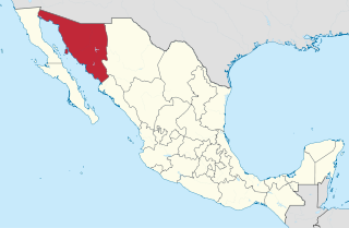
Sonora, officially Estado Libre y Soberano de Sonora, is one of the 31 states which, along with Mexico City, comprise the Federal Entities of Mexico. The state is divided into 72 municipalities; the capital city of which being Hermosillo, located in the center of the state. Other large cities include Ciudad Obregón, Nogales, San Luis Río Colorado, and Navojoa.

Baja California Sur, officially Estado Libre y Soberano de Baja California Sur, is the least populated state and the 31st admitted state of the 32 federal entities which comprise the 31 States of Mexico. It is also the ninth-largest Mexican state in terms of area.

Nayarit, officially the Estado Libre y Soberano de Nayarit, is one of the 31 states that, along with Mexico City, comprise the Federal Entities of Mexico. It is divided in 20 municipalities and its capital city is Tepic.

Sinaloa, officially the Estado Libre y Soberano de Sinaloa, is one of the 31 states which, along with Mexico City, comprise the Federal Entities of Mexico. It is divided into 18 municipalities, and its capital city is Culiacán Rosales.

Colima, officially the Free and Sovereign State of Colima, is among the 31 states that make up the 32 Federal Entities of Mexico. It shares its name with its capital and main city, Colima.

Culiacán, officially Culiacán Rosales, is a city in northwestern Mexico, the capital and largest city of both Culiacán Municipality and the state of Sinaloa. The city was founded on 29 September 1531 by the Spanish conquerors Lázaro de Cebreros and Nuño Beltrán de Guzmán under the name "Villa de San Miguel", referring to its patron saint, Michael the Archangel.

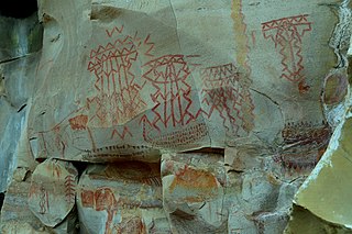
A petroglyph is an image created by removing part of a rock surface by incising, picking, carving, or abrading, as a form of rock art. Outside North America, scholars often use terms such as "carving", "engraving", or other descriptions of the technique to refer to such images. Petroglyphs, estimated to be 20,000 years old are classified as protected monuments and have been added to the tentative list of UNESCO's World Heritage Sites. Petroglyphs are found worldwide, and are often associated with prehistoric peoples. The word comes from the Greek prefix petro-, from πέτρα petra meaning "stone", and γλύφω glýphō meaning "carve", and was originally coined in French as pétroglyphe.

Mazatlán is a city in the Mexican state of Sinaloa. The city serves as the municipal seat for the surrounding municipio, known as the Mazatlán Municipality. It is located on the Pacific coast across from the southernmost tip of the Baja California Peninsula.

Guasave is a city and the seat of the homonymous municipality known as the Agricultural Heart of Mexico in the Mexican state of Sinaloa. It is located in the northwestern part of Mexico, 62km southeast of the city of Los Mochis and 150km northeast the state capital Culiacán. It stands at 25°34′04.5″N108°28′10.8″W.

In archaeology, rock art is human-made markings placed on natural surfaces, typically vertical stone surfaces. A high proportion of surviving historic and prehistoric rock art is found in caves or partly enclosed rock shelters; this type also may be called cave art or parietal art. A global phenomenon, rock art is found in many culturally diverse regions of the world. It has been produced in many contexts throughout human history. In terms of technique, the four main groups are:

Chiapa de Corzo is a small city and municipality situated in the west-central part of the Mexican state of Chiapas. Located in the Grijalva River valley of the Chiapas highlands, Chiapa de Corzo lies some 15 km (9.3 mi) to the east of the state capital, Tuxtla Gutiérrez. Chiapa has been occupied since at least 1400 BCE, with a major archeological site which reached its height between 700 BCE and 200 CE. It is important because the earliest inscribed date, the earliest form of hieroglyphic writing and the earliest Mesoamerican tomb burial have all been found here. Chiapa is also the site of the first Spanish city founded in Chiapas in 1528. The "de Corzo" was added to honor Liberal politician Angel Albino Corzo.
Cuevas or Cueva may refer to:

Chacala is a beach town set in small cove on the Pacific coast of Mexico in the State of Nayarit. It is located near pueblo Las Varas, about 100 kilometers (62 mi) north of Puerto Vallarta, and is part of the coastline known as the Riviera Nayarita. The name means "where there are shrimp" in Náhuatl. The population consists of approximately 300 full-time residents but can swell to over 1000 during Mexico's most popular vacation periods, such as Semana Santa and Christmas. Chacala is known for its physical beauty and unhurried lifestyle.

The Altavista petroglyph complex is located near the village and beach-town of Chacala, south of the Compostela Municipality, in Nayarit Mexico.

The Autonomous University of Sinaloa is a public university with its central campus located in the state capital of Culiacán, Sinaloa and with campuses in multiple locations within the state. The university is ranked in the top 25 universities of Mexico.

Zapatera is an archaeological site located on Isla Zapatera, a volcanic island in Lake Nicaragua, Granada Department, Nicaragua. The large quantity of statues, petroglyphs and pottery found at the site, and on other islands in the Zapatera archipelago, suggests the area was an important ceremonial centre of pre-Columbian Chorotega people between 800 and 1350 CE.

The Cantabrian caves' unique location make them an ideal place to observe the settlements of early humans thousands of years ago. The magnificent art in the caves includes figures of various animals of the time such as bison, horses, goats, deer, cattle, hands and other paintings. Archaeologists have found remains of animals such as bears, the remains of arrows and other material indicating a human presence; these artifacts are now found mostly in the Regional Museum of Prehistory and Archaeology of Cantabria.
Chiquihuitillos is an archaeological site situated in the municipality of Mina in Nuevo León, Mexico. The site is renowned for its petroglyphs and holds significance in the region's history.
Cueva Ahumada is an archaeological site located within several canyons in the village of La Rinconada, García Municipality, in the Mexican state of Nuevo León. Cave painting in northeastern Mexico covers two types of artwork: rock engraving, also called petroglyphs. A third type of rock art, geoglyphs so far has not been detected in this region.
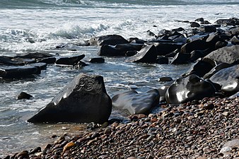 Petroglyphs of the archaeological site of Las Labradas, situated on the coast of the municipality of San Ignacio (Mexican state of Sinaloa)
 Petroglyphs of the archaeological site of Las Labradas, situated on the coast of the municipality of San Ignacio (Mexican state of Sinaloa)
 Petroglyphs of the archaeological site of Las Labradas, situated on the coast of the municipality of San Ignacio (Mexican state of Sinaloa)
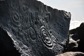 Petroglyphs of the archaeological site of Las Labradas, situated on the coast of the municipality of San Ignacio (Mexican state of Sinaloa)
 Petroglyphs of the archaeological site of Las Labradas, situated on the coast of the municipality of San Ignacio (Mexican state of Sinaloa)


