Concordia is a city and its surrounding municipality in the Mexican state of Sinaloa. The town is noted for manufacture of artesinal wooden furniture, symbolized by the giant chair in the town plaza. According to 2010 census, it had a population of 8,328 inhabitants.

Ahome is a municipality on the coast of the Gulf of California in the northwestern part of the Mexican state of Sinaloa; it is adjacent to the southern border of Sonora state. It reported 388,344 inhabitants in the 2005 census. Ahome is also the name of the second-largest community in the municipality. The municipal seat is the port city of Los Mochis, its largest community. It is a commercial corridor to the northwest of the country. It is situated on the Pacific coastal plain, at the entrance of the Gulf of California and lies in the heart of a rich agricultural region, Fort Valley. It stands at 25°33′50″N108°46′00″W.
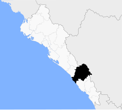
San Ignacio or San Ignacio de Piaxtla is a city and seat of the surrounding San Ignacio Municipality in the Mexican state of Sinaloa.
Mulegé is the northernmost municipality of the Mexican state of Baja California Sur. It is the largest municipality by area in Mexico, with an area of 33,092.20 km2. In the 2020 Census, it had a population of 64,022 inhabitants. Isla Natividad is part of the municipality.
Tepehuanes is a municipality in the Mexican state of Durango. It is located in the North West of Durango at 25°12'"-26°25'"N 105°23'"-106°40'"W, at an elevation of about 1,830 meters (6000 feet).

Ojuelos de Jalisco is a town and municipality in the state of Jalisco, Mexico. The town's 1990 population was 7,265, although by the year 2010 it had increased to 11,881.

San Juan Bautista Tuxtepec, or simply referred to as Tuxtepec, is the head of the municipality by the same name and is the second most populous city of the Mexican state of Oaxaca. It is part of the Tuxtepec District of the Papaloapan Region. As of the 2020 census, the city is home to a population of 103,609 and 159,452 in the municipality, though census data are often under reported for various reasons.
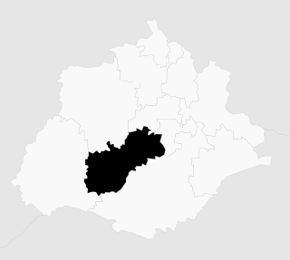
Chimalhuacán is a city and municipality located in the eastern part of State of Mexico, Mexico. It lies just outside the northeast border of Mexico City and is part of the Greater Mexico City urban area.
El Desemboque is a town located 376 km from Hermosillo on the shore of Gulf of California in the Mexican state of Sonora; coordinates N 29° 30' 13", W 112° 23' 43". It is part of the Municipality of Pitiquito, and is one of two major villages on the Seri Indian communal property, the other being Punta Chueca. The Spanish name refers to the fact that the Río San Ignacio meets the sea near that point. The Seri name is literally where the clams lie. It has been a good location to find the small clams Protothaca grata (haxöl). According to the Mexican census of 2010, the town had a population of 287 inhabitants. (The town of El Desemboque described in the prior text is not located in the Pitiquito municipality of Sonora. It is a Seri village about 120 km north of Punta Chueca north of Bahia Kino where the dry Rio Ignacio meets the Gulf of California. The El Desemboque in Pitiquito is west of Caborca at the mouth of Rio Concepcion and is a small village catering to weekenders from Caborca. The Seri may have lived at the El Desemboque west of present-day Caborca in prehistoric times before Spanish arrived as well as the current Seri town north of Bahia Kino. Their oral history has them living as far north as present day Puerto Penasco which was also an O'Odham settlement as well as present-day Bahia Kino and Isla Tiburon .)

Comonfort is a Mexican town and municipality in the state of Guanajuato, declared a Pueblo Mágico since 2018. It was named after Mexican general and President Ignacio Comonfort. The municipality has an area of 485.90 square kilometres and is bordered to the north and northeast by San Miguel de Allende, to the east by the state of Querétaro, to the south and southwest by, Apaseo el Grande, Celaya and Santa Cruz de Juventino Rosas, respectively. The municipality had a population of 67,642 inhabitants according to the 2005 census.
Tamazula de Victoria is a small town and seat of the municipality of Tamazula in the Mexican state of Durango. The town is located approximately 53 mi (85 km) east of the city center of Culiacán, Sinaloa, in the Sierra Madre Occidental mountains. The Tamazula River crescents directly north of the city.

Altamirano is a municipality in the Mexican state of Chiapas. The municipality covers an area of 1120 km2. As of 2010, the municipality had a total population of 29,865, up from 21,948 as of 2005.

Frontera Hidalgo is a town and municipality in the Mexican state of Chiapas in southern Mexico. It covers an area of 106.8 km2 (41.2 sq mi).
Jesús María is a municipality in the Mexican state of Aguascalientes. It stands at 21°58′N102°21′W. As of 2010, the municipality had a total population of 99,590.
Lerdo de Tejada is a municipality in the Mexican state of Veracruz, located 207 kilometres (129 mi) southeast of the state capital Xalapa. It is named after Sebastián Lerdo de Tejada, the 27th President of Mexico.
Álamos Municipality is a municipality in south-western Sonora, Mexico. It includes the town of Álamos.
San Ignacio Río Muerto Municipality is a municipality in the Mexican state of Sonora in north-western Mexico.

Municipality of Cosalá is a municipality in the Mexican state of Sinaloa in northwestern Mexico.
San Ignacio Cerro Gordo is a municipality in Jalisco, Mexico. It was established by the Congress of the State of Jalisco, on 1 January 2007 out of Arandas. Decree Number 20371 was published in the Periódico Oficial El Estado de Jalisco, on 30 December 2003, three years before the creation of this municipality, to allow its municipal authorities to be elected by the citizens in the election of municipal presidents on 2 July 2006.
The current municipality of Ignacio de la Llave, previously known as San Cristobal de la Llave, is placed in the popularly known region of La Mixtequilla, which is located in the western limit of the Papaloapan river, going through the Blanco, Limón and Las Pozas rivers. The climate of the region varie between hot-humid and tropical-humid, with frequent summer rains between July and September. The average temperature is from 64 and 72 °F, with a maximum registered in the high 70s °F (24-26°C) and the lowest in the high 40 °F (7-9°C). Ignacio de la Llave is neighbor and has deep political, social and trading relationships with: Alvarado, Acula, Ixmatlahuacan, Tlalixcoyan and Tierra Blanca.