Coatepec Harinas is one of 125 municipalities in the State of Mexico, Mexico. The municipal seat is the town of Coatepec Harinas. The original name is "Coauhtepetl" which means 'serpent hill' in Náhuatl. Around 1825 because of a boom in flour production, the name "Harinas" was added.
Angostura is a city and it is seat of its surrounding municipality in the Mexican state of Sinaloa. It stands at 25°21′55″N108°09′44″W.

Guasave is a city and the seat of the homonymous municipality known as the Agricultural Heart of Mexico in the Mexican state of Sinaloa. It is located in the northwestern part of Mexico, 62km southeast of the city of Los Mochis and 150km northeast the state capital Culiacán. It stands at 25°34′04.5″N108°28′10.8″W.

The Mayo or Yoreme are an Indigenous group in Mexico, living in southern Sonora, northern Sinaloa and small settlements in Durango.

Ciudad Nicolás Romero is the largest city and municipal seat of the municipality of Nicolás Romero in the State of Mexico, Mexico. It is located 58 km from the city of Toluca, the state capital and lies in the north-central part of the state, just northwest of the Federal District. The seat/municipality's current name is to honor Nicolás Romero, who fought for Benito Juárez during the Reform War and the French intervention in Mexico. He was executed there by the French. The town adopted this name in 1898. The area was settled by the Otomi and named Azcapotzaltongo by the Aztecs after conquering it. During colonial times, it was known as San Pedro Azcapotzaltongo. It was then called Monte Bajo from 1821 to 1898, when the current name was adopted. Both the municipality and city are commonly referred to as Nicolás Romero.

Agrícola Oriental is a metro station on Line A of the Mexico City Metro system. It is located in the Iztacalco municipality. In 2019, the station had an average ridership of 11,317 passengers per day, making it the least used station in Line A.

San Juan Bautista Tuxtepec, or simply referred to as Tuxtepec, is the head of the municipality by the same name and is the second most populous city of the Mexican state of Oaxaca. It is part of the Tuxtepec District of the Papaloapan Region. As of the 2020 census, the city is home to a population of 103,609 and 159,452 in the municipality, though census data are often under reported for various reasons.
Chimalhuacán is a city and municipality located in the eastern part of State of Mexico, Mexico. It lies just outside the northeast border of Mexico City and is part of the Greater Mexico City urban area.

Tlaxiaco is a city, and its surrounding municipality of the same name, in the Mexican state of Oaxaca. It is located in the Tlaxiaco District in the south of the Mixteca Region, with a population of about 17,450.
Álamos Municipality is a municipality in south-western Sonora, Mexico. It includes the town of Álamos.
Municipality of El Fuerte is a municipality in the Mexican state of Sinaloa in northwestern Mexico. Its seat is El Fuerte city.
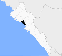
Municipality of Mocorito is a municipality in the Mexican state of Sinaloa in northwestern Mexico. It is bordered to the north by the municipality of Sinaloa, to the south by Navolato, to the southeast by Culiacán, to the east by Badiraguato and to the west with Salvador Alvarado and Angostura. It encompasses a total of 2,800.6 km² and represents 4.9% of the territory of Sinaloa. According to the 2020 census it had a population of 40,358, compromising 270 total localities. Major localities include Pericos, Mocorito, and Caimanero.

Colonia Asturias is a colonia or neighborhood in the Cuauhtémoc borough, south of the historic center of Mexico City. It is a lower-class residential neighborhood, whose borders are formed by the following streets, Calles Hernández y Dávalos in the north, Viaducto Piedad in the south, Calzada de la Viga in the east and Calzada San Antonio Abad in the west.

Colonia Atlampa is a colonia or neighborhood located in the Cuauhtémoc borough, northwest of the historic center of Mexico City. The boundaries of the area are marked by the following streets: Calzada de Nonoalco or Ricardo Flores Magón Street to the south, Circuito Interior Paseo de las Jacarandas to the north, Avenida Insurgentes Norte to the east and Circuito Interior Instituto Politécnico Industrial to the west. The neighborhood is considered lower class and working class. The name is derived from a Nahuatl phrase meaning "where the water divides."

Colonia Cuauhtémoc is a colonia in the Cuauhtémoc municipality of central Mexico City. It is located just north of Paseo de la Reforma, west of the historic center of Mexico City.
Colonia Esperanza is a small colonia or neighborhood located in the Cuauhtémoc borough of Mexico City just southeast of the historic center. Its borders are defined by the following streets: Lorenzo Boturini to the south, Fray Servando Teresa de Mier to the north, Calzada de la Viga Canal to the east and Francisco Javier Clavijero to the west.
Colonia Paulino Navarro is a colonia or neighborhood in the Cuauhtémoc borough of Mexico City, just southeast of the city’s historic center. Its boundaries are defined by the following streets: Ventura G. Tena and Hernández y Dávalos to south, Calzada de la Chabacano to the north, Calzada de la Viga to the east and Calzada de San Antonio Abad to the west.
The river Guadalmina is a short coastal river of the Mediterranean basin in southern Spain that runs entirely within the Andalusian province of Málaga.
Escandón is one of the colonias of Mexico City that were founded at the beginning of the 19th century on crop terrains that were formerly part of Hacienda de la Condesa, belonging to Condesa de Miravalle. This colony formed part of the Hacienda de la Condesa, being property of the family Escandón, who fractionated the terrains situated south of this. In 1841 it was sold to Antonio Batres and then sold to Estanislao and Joaquín Flores. The Flores brothers sold the hacienda to Manuel Escandón's notary in 1869. When the Escandón family acquired the property it got fragmented in 1880, 1890 and 1891 to be put for sale in lots.
El Parral is a municipality in the Mexican state of Chiapas, located approximately 45 kilometres (28 mi) south of the state capital of Tuxtla Gutiérrez.