Municipality of Navolato | |
|---|---|
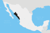
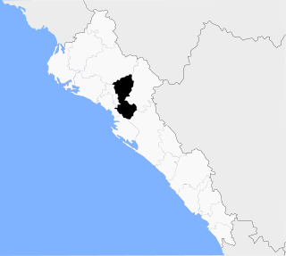
 Location of the municipality in Sinaloa | |
| Country | |
| State | Sinaloa |
| Time zone | UTC-7 (MST) |
Municipality of Navolato is a municipality in the Mexican state of Sinaloa in northwestern Mexico. [1]
Municipality of Navolato | |
|---|---|
| Location of the municipality in Sinaloa | |
| Country | |
| State | Sinaloa |
| Time zone | UTC-7 (MST) |
Municipality of Navolato is a municipality in the Mexican state of Sinaloa in northwestern Mexico. [1]

Culiacán, officially Culiacán Rosales, is a city in northwestern Mexico, the capital and largest city of both Culiacán Municipality and the state of Sinaloa. The city was founded on 29 September 1531 by the Spanish conquerors Lázaro de Cebreros and Nuño Beltrán de Guzmán under the name "Villa de San Miguel", referring to its patron saint, Michael the Archangel.

Badiraguato is a small city and seat of the Badiraguato Municipality in the Mexican state of Sinaloa. It stands at 25°21′47″N107°33′06″W. According to 2010 census, the city reported 3,725 inhabitants. The hamlet of La Tuna, located 110 kilometres to the North of the city, is the birthplace of Joaquín "El Chapo" Guzmán, for a long time one of Mexico's most powerful drug lords.
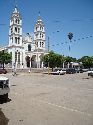
Navolato is a city in the Mexican state of Sinaloa. It is located in the central coastal part of the state bordering the Gulf of California and serves as the municipal seat for the surrounding municipality of the same name.

Altata is a small town in Navolato Municipality connected to the Pacific Ocean, located about 45 miles west of Culiacán, Sinaloa in Mexico by Freeway 30.
The Autonomous University of Sinaloa is a public university with its central campus located in the state capital of Culiacán, Sinaloa and with campuses in multiple locations within the state. The university is ranked in the top 25 universities of Mexico.
The United States Border Patrol operates 71 traffic checkpoints, including 33 permanent traffic checkpoints, near the Mexico–United States border. The stated primary purpose of these inspection stations is to deter illegal immigration and smuggling activities. After the September 11 attacks in 2001, they took on the additional role of terrorism deterrence. These checkpoints are located between 25 and 75 miles of the Mexico–United States border along major U.S. highways; near the southern border of the contiguous United States. Their situation at interior locations allow them to deter illegal activities that may have bypassed official border crossings along the frontier. The checkpoints are divided among nine Border Patrol sectors. There are a number of these checkpoints near the northern border of the contiguous U.S. as well, within 100 miles (160 km) of the Canada–U.S. border.

Jilotzingo is one of 125 municipalities in the State of Mexico in Mexico. The municipal seat is the town of Santa Ana Jilotzingo, which is the 4th largest town in the municipality. The municipality covers an area of 143.66 km².
San Miguel Suchixtepec is a town and municipality in Oaxaca in south-western Mexico. The municipality covers an area of 107.17 km². It is part of the Miahuatlán District in the south of the Sierra Sur Region.
Santo Domingo de Morelos is a town and municipality in Oaxaca in south-western Mexico. The municipality covers an area of 107.17 km². It is part of the Pochutla District in the east of the Costa Region.

Ayotoxco de Guerrero (municipality) is a town and municipality in the Mexican state of Puebla in south-eastern Mexico.

General Felipe Ángeles (municipality) is a town and municipality in the center of the state of Puebla in south-eastern Mexico. It is named after General Felipe Ángeles.

Huehuetlán el Grande (municipality) is a town and municipality in the state of Puebla in south-eastern Mexico.
Tepexco is a town and municipality in the Mexican state of Puebla in south-eastern Mexico.
Álamos Municipality is a municipality in south-western Sonora, Mexico. It includes the town of Álamos.

Municipality of Badiraguato is a municipality in the Mexican state of Sinaloa in northwestern Mexico. The seat of the municipality is in the small town of Badiraguato.
Municipality of Mocorito is a municipality in the Mexican state of Sinaloa in northwestern Mexico. It is bordered to the north by the municipality of Sinaloa, to the south by Navolato, to the southeast by Culiacán, to the east by Badiraguato and to the west with Salvador Alvarado and Angostura. It encompasses a total of 2,800.6 km² and represents 4.9% of the territory of Sinaloa. According to the 2020 census it had a population of 40,358, compromising 270 total localities. Major localities include Pericos, Mocorito, and Caimanero.
Operation Sinaloa or Operation Culiacan - Navolato is an ongoing anti-drug trafficking operation in the Mexican state of Sinaloa by the Federal Police and the Mexican Armed Forces. Its main objective is to cripple all cartel organizations such as the Sinaloa Cartel, Beltrán-Leyva Cartel and Los Zetas that operate in that state. The Military was deployed in response to the murder of Mexico's Federal Police commissioner Édgar Eusebio Millán Gómez.
Voljčince is a village in the municipality of Žitorađa, Serbia. According to the 2002 census, the village has a population of 937 people.
Dautillos is a town in the municipality of Navolato, Mexico. It is one meter above sea level.

Hurricane Manuel brought widespread flooding across much of Mexico in September 2013, in conjunction with Hurricane Ingrid. The fifteenth named storm and seventh hurricane of the annual hurricane season, Manuel originated from a strong area of low pressure south of Acapulco on September 13. Within favorable conditions aloft, the storm intensified into a tropical storm as it tracked northward. The following day, Manuel curved westward and strengthened to a point just shy of hurricane intensity before making its first landfall at that intensity on September 15. Due to interaction with land, the tropical storm quickly weakened, and its center dissipated over western Mexico on September 16. However, the storm's remnants continued to track northwestward into the Gulf of California, where they reorganized into a tropical cyclone the next day. Manuel regained tropical storm status on September 18 as it began to curve northeastward. Shortly thereafter, Manuel attained Category 1 hurricane intensity, before making its final landfall just west of Culiacán at peak intensity. Over land, Manuel quickly weakened due to interaction with Mexico's high terrain, and the storm dissipated early on September 20.
| Authority control databases: Geographic |
|---|
24°45′55″N107°42′06″W / 24.76528°N 107.70167°W
| | This article about a location in the Mexican state of Sinaloa is a stub. You can help Wikipedia by expanding it. |