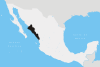
Sinaloa, officially the Estado Libre y Soberano de Sinaloa, is one of the 31 states which, along with Mexico City, comprise the Federal Entities of Mexico. It is divided into 18 municipalities, and its capital city is Culiacán Rosales.

Culiacán, officially Culiacán Rosales, is a city in northwestern Mexico, the capital and largest city of both Culiacán Municipality and the state of Sinaloa. The city was founded on 29 September 1531 by the Spanish conquerors Lázaro de Cebreros and Nuño Beltrán de Guzmán under the name "Villa de San Miguel", referring to its patron saint, Michael the Archangel.

Ismael Mario Zambada García is a Mexican drug lord, co-founder and current top leader of the Sinaloa Cartel, an international crime syndicate based in Sinaloa. Before he assumed leadership of the entire cartel, he allegedly served as the logistical coordinator for its Guzmán-Zambada organization, which has overseen the trafficking of cocaine and heroin into Chicago and other US cities by aircraft, narcosubs, container ships, go-fast boats, fishing vessels, buses, rail cars, tractor trailers, and automobiles. As of 2024, he has never been arrested or incarcerated and is the single last remaining fugitive on the list of Mexico's 37 most-wanted drug lords.

Mazatlán is a city in the Mexican state of Sinaloa. The city serves as the municipal seat for the surrounding municipio, known as the Mazatlán Municipality. It is located on the Pacific coast across from the southernmost tip of the Baja California Peninsula.

Badiraguato is a small city and seat of the Badiraguato Municipality in the Mexican state of Sinaloa. It stands at 25°21′47″N107°33′06″W. According to 2010 census, the city reported 3,725 inhabitants. The hamlet of La Tuna, located 110 kilometres to the North of the city, is the birthplace of Joaquín "El Chapo" Guzmán, for a long time one of Mexico's most powerful drug lords.

El Fuerte is a city and El Fuerte Municipality its surrounding municipality in the northwestern Mexican state of Sinaloa. The city population reported in the 2010 census was 12,566 people.

El Rosario is a city and its surrounding municipality in the Mexican state of Sinaloa. It stands at 22°45′00″N105°22′16″W.
Rosario is the largest city of the province of Santa Fe, and the third-largest city in Argentina.
Huajicori is both a municipality and the municipal seat of the same in the Mexican state of Nayarit. The population of the municipality was 10,294 in 2000 in a total area of 2,603.5 km2. Its area makes up almost 10% of the state. The population of the town was 2,201 (2005).

The Sinaloa Cartel, also known as the Guzmán-Zambada Organization, the Federation, the Blood Alliance, or the Pacific Cartel, is a large, international organized crime syndicate based in the city of Culiacán, Sinaloa, Mexico that specializes in illegal drug trafficking and money laundering.

The Autonomous University of Sinaloa is a public university with its central campus located in the state capital of Culiacán, Sinaloa and with campuses in multiple locations within the state. The university is ranked in the top 25 universities of Mexico.

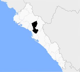
Municipality of Badiraguato is a municipality in the Mexican state of Sinaloa in northwestern Mexico. The seat of the municipality is in the small town of Badiraguato.

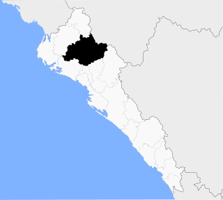
Municipality of Culiacán is a municipality in the Mexican state of Sinaloa in northwestern Mexico.
Municipality of Mocorito is a municipality in the Mexican state of Sinaloa in northwestern Mexico. It is bordered to the north by the municipality of Sinaloa, to the south by Navolato, to the southeast by Culiacán, to the east by Badiraguato and to the west with Salvador Alvarado and Angostura. It encompasses a total of 2,800.6 km² and represents 4.9% of the territory of Sinaloa. According to the 2020 census it had a population of 40,358, compromising 270 total localities. Major localities include Pericos, Mocorito, and Caimanero.
Municipality of Sinaloa is a municipality in the Mexican state of Sinaloa in northwestern Mexico. Its seat is Sinaloa de Leyva.
The Milenio Cartel, or Cártel de los Valencia, was a Mexican criminal organization based in Michoacán. It relocated to Jalisco in the early 2000s. The Jalisco New Generation Cartel was born from the splintering of the Milenio Cartel.
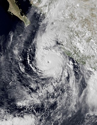
Hurricane Willa was a powerful tropical cyclone that brought torrential rains and destructive winds to southwestern Mexico, particularly the states of Sinaloa and Nayarit, during late October 2018. It was the twenty-fifth tropical cyclone, twenty-second named storm, thirteenth hurricane, tenth major hurricane, and record-tying third Category 5 hurricane of the 2018 Pacific hurricane season. Willa was the first major hurricane to make landfall in the Mexican state of Sinaloa since Lane in 2006.
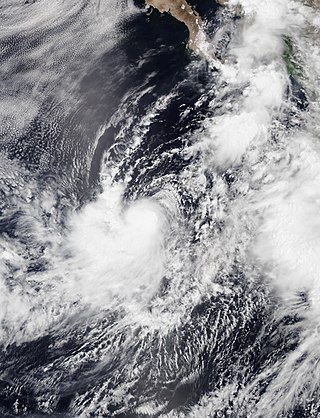
Tropical Storm Ivo was a tropical cyclone that brought heavy rainfall to five states in Mexico, causing severe flooding during August 2019. The tenth tropical cyclone and ninth named storm of the 2019 Pacific hurricane season, Ivo arose from a low-pressure area that spawned south of Guatemala on August 16. The low-pressure system gradually organized over the next several days as it tracked west-northwestward. The system coalesced into a tropical depression early on August 21 and strengthened into Tropical Storm Ivo several hours later. Located within a favorable environment of moist air and warm sea surface temperatures, the cyclone quickly intensified, peaking the next day with 1-minute maximum sustained winds of 70 mph (110 km/h) and a pressure of 990 mbar (29.23 inHg). Increasing wind shear caused the storm's intensification to level off later that day, as the system turned towards the north-northwest. Ivo passed by Clarion Island midday on August 23, generating winds of 60 mph (100 km/h) on the island. Wind shear caused Ivo to significantly degrade in structure and intensity during the next couple of days. Cold sea surface temperatures, as well as dry and stable air, caused the cyclone to degenerate into a remnant low early on August 25. The low meandered over the eastern Pacific before opening up into a trough of low pressure early on August 27.

Hurricane Orlene was a powerful tropical cyclone that caused minor damage to the Pacific coast of Mexico in October 2022. The cyclone was the sixteenth named storm, ninth hurricane, and third major hurricane of the 2022 Pacific hurricane season. Orlene originated from a low-pressure area off the coast of Mexico. Moving towards the north, Orlene gradually strengthened, becoming a hurricane on October 1 and reaching its peak intensity the following day with winds of 130 mph (215 km/h). Orlene made landfall just north of the Nayarit and Sinaloa border, with winds of 85 mph (140 km/h). Soon afterward, Orlene rapidly weakened and became a tropical depression, eventually dissipating over the Sierra Madre Occidental late on October 4.