Navolato, Sinaloa

Last updated
Navolato, Sinaloa
Navolato, Sinaloa.jpg
Parroquia de San Francisco de Asís in Navolato
Coat of arms of Navolato, Sinaloa.svg
Mexico Sinaloa location map.svg
Red pog.svg
Navolato, Sinaloa
Location in Sinaloa
Mexico States blank map.svg
Red pog.svg
Navolato, Sinaloa
Navolato, Sinaloa (Mexico)
Coordinates: 24°45′56″N107°42′07″W / 24.76556°N 107.70194°W / 24.76556; -107.70194
CountryFlag of Mexico.svg  Mexico
State Sinaloa
Municipality Navolato
Population
 (2010)
  Total28,676
Time zone UTC-7 (Pacific (US Mountain))
Area code 672

Navolato is a city in the Mexican state of Sinaloa. It is located in the central coastal part of the state bordering the Gulf of California and serves as the municipal seat for the surrounding municipality of the same name.

Contents

The municipality reported 135,603 inhabitants in the 2010 census, while the city reported 29,153 inhabitants. [1] The city is located about 25 kilometers west of Culiacán and can be reached by road. The municipality is 2,285 km2 (882 sq mi) in area and includes many smaller communities in addition to the city of Navolato; the largest of these are the towns of Campo Gobierno, and General Ángel Flores (La Palma).

The name Navolato comes from the native Nahuatl language. The people in Navolato produce sugarcane, maize, and other agricultural products. Nearby tourist destinations are Altata, Nuevo Altata, and El Tambor.

Culture

The music in the municipal of Navolato is developed through bandas or brass bands, trios, cuartetos, or other forms of musical expressions in which they use in order to sing to their land. According to Encyclopedia of the Municipals of Mexico Sinaloa, "They invited diverse artists to use their musical passions to sing to their people, and to all of their natural beauty that surrounds them." They had local composers and strangers sing beautiful songs for the state of Sinaloa, where Navolato is located in. Severiano Briseño Chávez composed the song "El Sinaloense" (The Sinaloen), which was one of the most greatest composed songs in Sinaloa, Navolato still to this day. Jose Angle Espinoza Ferrusquilla did a homage for his land with the song "En Sinaloa Naci"which means "Born in Sinaloa." In Navolato, Sinaloa, according to Portal Grupero, "The singer Valente Del Real was born in 1985. He started his musical career at the young age of eleven years. He has since pretained to various groups, where he learned to play various instruments. For instance the drums, the base and the guitar were his most played instruments. His voice is very similar to that of the disappeared Valentin Elizalde. He also usually does his performances with Banda Pueblo Lindo.[ citation needed ]

In the Altata Bay, there are many different types of marine species. The Encyclopedia of the Municipal of Mexico Sinaloa stated that," They catch shrimp, tuna, clams, oysters, scallops, and marlin." Not to mention, they also catch a large variety of sweet water fish. In this community of Navolato they enjoy a variety of different styles of fish based plates. This includes: meatballs made of fish, chile rellenos filled with crab, and their famous Sinaloa style shrimp Cevichi. Their favorite dessert is Jamoncillo which is "Dulce de leche."This dessert is made with the conserves and piloncillos derivatives of the grindings of sugar canes. However, their most famous dessert is the "tacuarines" which is a cookie made of corn, flour and water in the shape of circles other various forms.[ citation needed ]

Demographics

Sinaloa Navolato lies along the coast of the Gulfo de California. It covers an area of 58,091 square kilometers (22,429 square miles), which is a slightly smaller than Norway. In Sinaloa Navolato, there are three types of landscape: a coastal plan in the west, mountains (sierras) in the east, and valleys between them. In the eastern part of the state Sierra Madre Occidental is known by different names. Valleys lie between the ranges of mountains and the coastal plan, where the land is flat with few hills. The rivers rise in the Sierra Madre Occidental and cross the state to flow into the Gulfo de California and the Pacific Ocean. Major rivers are the Fuerte and Sinaloa. Sinaloa had a total population of 2,536,844 in 2000; of the total, 1,264,143 were men and 1,272,701 were women, according to the Junior Worldmark Encyclopedia of the Mexican States. [2] It also stated that, “The population density was 44 people per square kilometer (114 people per square mile).” Almost all citizens speak Spanish as their first language. A small number, about 2.2% of the population speaks indigenous (native) languages in Sinaloa Navolato. According to the Junior Worldmark Encyclopedia of the Mexican States, “77% of the population, or about two million people, were Roman Catholic; almost 3%, or 65,346 people, were Protestant.” That year there were also 32,783 Jehovah's witnesses and over 180,000 people who reported no religion. Sinaloa Navolato is not very well known by most people, but it is a rather unusual place to know and learn about. For example, the name Sinaloa comes from the Chaita language. It is a combination of the words sina, which means pithaya (a plant with thorny stalks), and lobola, which means rounded. The pithaya is a common plant throughout the region, which has great meaning.

Geography

In Navolato according to the Junior Worldmark Encyclopedia of the Mexican States, "Along the coastal plains of Sinaloa it remains hot even after cold times.” Temperatures in the daytime can be up to 90 degrees and in winter times like around December, January, and February can be up to 80 degrees. Most of the rain fall occurs in July, August, and September along with cooling temperatures by the coast. [2] This part of Sinaloa is mostly watched by the Environmental Protection Agency due tremendous climate change. In the Junior Worldmark Encyclopedia of the Mexican States it says, “That this part of Mexico has teamed up with U.S. and Alaska to form a group called the Western Hemisphere Shorebird Reserve Network.” The reason why it was named this is because of the Pacific Flyway Shorebirds that breed in Canada, Alaska, and other West Coastal regions of the United States. According to MagnaVerno, “Watering prior to harvest allows the basil to be cut/harvested three times.” Plants here can range from oaks to poplars to cieba and mangroves, which is an evergreen that usually grows along the coast. Fruit like lemons, peaches and pears are also known to be found as well. Animals that can be found in this area are: dears, wildcats, badgers, wild boar, coyotes and tlacuaches. However, fishing is another great part of Navolato, which holds second place national level terms of value of production, and third in fish and other seafood.

Climate

Climate data for Navolato (1951–2010)
MonthJanFebMarAprMayJunJulAugSepOctNovDecYear
Record high °C (°F)39.5
(103.1)
39.5
(103.1)
37.5
(99.5)
41.5
(106.7)
42.0
(107.6)
43.0
(109.4)
44.0
(111.2)
42.0
(107.6)
43.0
(109.4)
42.0
(107.6)
42.0
(107.6)
37.0
(98.6)
44.0
(111.2)
Mean daily maximum °C (°F)27.7
(81.9)
29.2
(84.6)
31.0
(87.8)
33.1
(91.6)
35.6
(96.1)
36.4
(97.5)
36.6
(97.9)
36.4
(97.5)
35.5
(95.9)
35.1
(95.2)
32.6
(90.7)
28.6
(83.5)
33.2
(91.8)
Daily mean °C (°F)19.4
(66.9)
20.2
(68.4)
21.6
(70.9)
23.7
(74.7)
26.3
(79.3)
29.1
(84.4)
30.0
(86.0)
30.2
(86.4)
29.6
(85.3)
27.9
(82.2)
24.0
(75.2)
20.0
(68.0)
25.2
(77.4)
Mean daily minimum °C (°F)11.1
(52.0)
11.1
(52.0)
12.2
(54.0)
14.2
(57.6)
17.0
(62.6)
21.7
(71.1)
23.4
(74.1)
24.0
(75.2)
23.8
(74.8)
20.8
(69.4)
15.3
(59.5)
11.4
(52.5)
17.2
(63.0)
Record low °C (°F)4.0
(39.2)
−1.0
(30.2)
7.5
(45.5)
9.0
(48.2)
11.0
(51.8)
10.0
(50.0)
10.0
(50.0)
18.0
(64.4)
16.0
(60.8)
11.0
(51.8)
5.0
(41.0)
5.0
(41.0)
−1.0
(30.2)
Average precipitation mm (inches)22.6
(0.89)
9.2
(0.36)
2.1
(0.08)
1.2
(0.05)
7.4
(0.29)
6.5
(0.26)
71.6
(2.82)
120.8
(4.76)
134.5
(5.30)
76.7
(3.02)
6.5
(0.26)
11.5
(0.45)
470.6
(18.53)
Average precipitation days (≥ 0.1 mm)2.01.10.40.20.11.27.49.88.72.91.01.336.1
Source: Servicio Meteorologico Nacional [3] [4]

Government

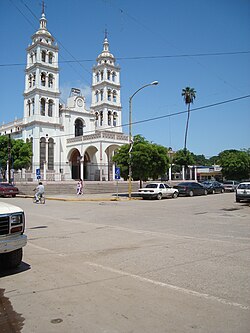
Navolato was part of the municipality of Culiacan until the year 1982 when it was constituted as a municipality. A decree was publicized in the official newspaper on August 27, constituting itself in a way as the eighteenth municipal of surrounding the community. There are a couple of historical monuments in Navolato according to the Encyclopedia of the Municipals of Mexico Sinaloa such as, "The Temple of San Francisco de Asis, which was built in 1950 and the Chapel of San Jose, which was built in 1927."

The judicial system is called the Tribunal of Justice, which is the highest court system in the state of Mexico. [2] The Supreme Tribunal of justice has eleven members that are assigned for fifteen years with no reappointment. There is a required retirement age of 70 years. According to Explorando Mexico,"the state governor of Navolato office is assisted by the departments of director's of liaisons and events, public relations. The Governor’s hearings are over seen by administrative and touring coordinators, as well private secretary and other auxiliary secretaries in charge of the Governor’s agenda, among other federal dependencies and autonomous organizations". [5]

Economy

Resources are formed from a variety of products that are from harvest fields that grow wheat, bean, fruits, potatoes, zucchini and sugar cane. Navolato is the largest industry in the state that produces a large exporting capacity, which has become an integral part of the state. Infrastructure transports its food and vegetables from two important international airports, which are Mazatlan and Topolobampo. Harvest is transported from Navolato to difference parts of Mexico to supply their markets, as while as their income. Navolato also depends on local railroads to transport merchandise and other food produces. Navolato economy is slowly expanding and finding new ways to build their cities. For example, telecommunications and electricity generated throughout their cities. Navolato government and economy is maintaining their judicial system and keeping becoming more proficient.

Navolato is most known for its renowned agricultural industry. Because of their versatile location, Navolato produces a large array of agricultural products. Navolato leads in the production of sugar cane, rice, vegetables, wheat, beans, and sea food. The fishing and horticulture is second following Navolato's natural resources, which are also leading asset to the nation income. “Agriculture and livestock account for about 21% of the economy". [6] The list of agriculture and livestock is very abundant due to the location. Many of the crops are produced through irrigation near sea level, which is what makes these crops such a high demand. Navolato is so famous for their agriculture, Navolato would be expected to produce and export their product in a timely manner. “Its high productivity allows participation in international markets by exporting fruit and vegetable products which represents more than 60% of the total exports in Sinaloa". [7] Navolatos agriculture is a highly prized business as well. “On a national level, it is among the first place in vegetables such a tomatoes, cucumber, pumpkins, potatoes, chilies, and eggplant, in fruits there are mangos, cantaloupes, and watermelon, and in grains, there corn, beans, soybeans, safflowers, rice, wheat, and sorgum". [7] The second largest business would be the livestock and the breeding of livestock. They are also most known for the fishing industry as well. Navolato is known for this because they are located right off the Pacific Ocean. By breeding livestock, Navolato farmers are able to succeed in the business of producing sausage, cheese, and milk among with other products made from livestock.

Notable people

Related Research Articles

<span class="mw-page-title-main">Nayarit</span> State of Mexico

Nayarit, officially the Estado Libre y Soberano de Nayarit, is one of the 31 states that, along with Mexico City, comprise the Federal Entities of Mexico. It is divided in 20 municipalities and its capital city is Tepic.

<span class="mw-page-title-main">Sinaloa</span> State of Mexico

Sinaloa, officially the Estado Libre y Soberano de Sinaloa, is one of the 31 states which, along with Mexico City, comprise the Federal Entities of Mexico. It is divided into 18 municipalities, and its capital city is Culiacán Rosales.

<span class="mw-page-title-main">Culiacán</span> City in Sinaloa, Mexico

Culiacán, officially Culiacán Rosales, is a city in northwestern Mexico, the capital and largest city of both Culiacán Municipality and the state of Sinaloa. The city was founded on 29 September 1531 by the Spanish conquerors Lázaro de Cebreros and Nuño Beltrán de Guzmán under the name "Villa de San Miguel", referring to its patron saint, Michael the Archangel.

<span class="mw-page-title-main">Ismael "El Mayo" Zambada</span> Mexican drug lord

Ismael Mario Zambada García is a Mexican drug lord, co-founder and current top leader of the Sinaloa Cartel, an international crime syndicate based in Sinaloa. Before he assumed leadership of the entire cartel, he allegedly served as the logistical coordinator for its Guzmán-Zambada organization, which has overseen the trafficking of cocaine and heroin into Chicago and other US cities by aircraft, narcosubs, container ships, go-fast boats, fishing vessels, buses, rail cars, tractor trailers, and automobiles. As of 2024, he has never been arrested or incarcerated and is the single last remaining fugitive on the list of Mexico's 37 most-wanted drug lords.

<span class="mw-page-title-main">Mazatlán</span> City in Sinaloa, Mexico

Mazatlán is a city in the Mexican state of Sinaloa. The city serves as the municipal seat for the surrounding municipio, known as the Mazatlán Municipality. It is located on the Pacific coast across from the southernmost tip of the Baja California Peninsula.

Emiliano Zapata is a city in the west-central part of the Mexican state of Morelos. It stands at 18°52′N99°09′W. The city serves as the county seat for the surrounding municipality of the same name. The municipality is the sixth largest in the state of Morelos, with a 2020 census population of 107,053 inhabitants, and has it an area of 64.983 km2. The city of Emiliano Zapata had 64,084 inhabitants in 2020. The city was previously known as both San Francisco Zacualpan and San Vicente Zacualpan. It was renamed in honor of Mexican Revolutionary Emiliano Zapata.

<span class="mw-page-title-main">Guaymas</span> City in Sonora, Mexico

Guaymas is a city in Guaymas Municipality, in the southwest part of the state of Sonora, in northwestern Mexico. The city is 134 kilometres (83 mi) south of the state capital of Hermosillo, and 389 kilometres (242 mi) from the U.S. border. The municipality's formal name is Guaymas de Zaragoza and the city's formal name is the Heroica Ciudad de Guaymas.

<span class="mw-page-title-main">Municipalities of Sinaloa</span>

Sinaloa is a state in northwest Mexico that is divided into 18 municipalities. According to the 2020 Mexican Census, it is the seventeenth most populated state with 3,026,943 inhabitants and the eighteenth largest by land area spanning 57,365.4 square kilometres (22,148.9 sq mi).

<span class="mw-page-title-main">Amado Carrillo Fuentes</span> Mexican drug lord (1956-1997)

Amado Carrillo Fuentes was a Mexican drug lord. He seized control of the Juárez Cartel after assassinating his boss Rafael Aguilar Guajardo. Amado Carrillo became known as "El Señor de Los Cielos", because of the large fleet of jets he used to transport drugs. He was also known for laundering money via Colombia, to finance this fleet.

The Juárez Cartel, also known as the Vicente Carrillo Fuentes Organization, is a Mexican drug cartel based in Ciudad Juárez, Chihuahua, across the Mexico—U.S. border from El Paso, Texas. The cartel is one of several drug trafficking organizations that have been known to decapitate their rivals, mutilate their corpses and dump them in public places to instill fear not only in the general public but also in local law enforcement and their rivals, the Sinaloa Cartel. Its current known leader is Juan Pablo Ledezma. The Juárez Cartel has an armed wing known as La Línea, a Juárez street gang that usually performs the executions and is now the cartel’s most powerful and leading faction. It also uses the Barrio Azteca gang to attack its enemies.

The Guadalajara Cartel, also known as The Federation, was a Mexican drug cartel which was formed in 1980 by Miguel Ángel Félix Gallardo, Rafael Caro Quintero, and Ernesto Fonseca Carrillo in order to ship cocaine and marijuana to the United States. Among the first of the Mexican drug trafficking groups to work with the Colombian cocaine mafias, the Guadalajara Cartel prospered from the cocaine trade. Throughout the 1980s, the cartel controlled much of the drug trafficking in Mexico and the corridors along the Mexico–United States border. It had operations in various regions in Mexico which included the states of Jalisco, Baja California, Colima, Sonora, Chihuahua and Sinaloa among others. Multiple modern present day drug cartels such as the Tijuana, Juárez and Sinaloa cartels originally started out as branches or "plazas" of the Guadalajara Cartel before its eventual disintegration.

Ernesto Fonseca Carrillo, commonly referred to by his alias Don Neto, is a Mexican drug lord and former leader of the Guadalajara Cartel, a defunct criminal group based in Jalisco. He headed the organization alongside Miguel Ángel Félix Gallardo, and Rafael Caro Quintero. Fonseca Carrillo was involved with drug trafficking since the early 1970s, primarily in Ecuador, and later moved his operations to Mexico.

<span class="mw-page-title-main">Juan José Esparragoza Moreno</span> Mexican drug trafficker (1949-2014)

Juan José Esparragoza Moreno, commonly referred to by his alias El Azul, was a Mexican drug lord and member of the Sinaloa Cartel, Guadalajara Cartel and Juárez Cartel, three large and powerful criminal organizations. Originally a member of the Dirección Federal de Seguridad (DFS) police agency, he founded the Guadalajara Cartel in the 1970s along with other drug kingpins in Mexico. Following its disintegration in the late 1980s, he went on to lead the Juárez Cartel and eventually settled in the Sinaloa Cartel. He worked alongside Joaquín "El Chapo" Guzmán and Ismael Zambada García, once considered world's most-wanted, powerful and rich drug lords.

Vicente Carrillo Fuentes, commonly referred to by his alias El Viceroy, is a Mexican convicted drug lord and former leader of the Juárez Cartel, a drug trafficking organization. The cartel is based in Chihuahua, one of the primary transportation routes for billions of dollars' worth of illegal drug shipments entering the United States from Mexico annually. He was one of Mexico's most-wanted drug lords until his capture in 2014.

Álamos Municipality is a municipality in south-western Sonora, Mexico. It includes the town of Álamos.

<span class="mw-page-title-main">Mocorito Municipality</span> Municipality in the Mexican state of Sinaloa

Municipality of Mocorito is a municipality in the Mexican state of Sinaloa in northwestern Mexico. It is bordered to the north by the municipality of Sinaloa, to the south by Navolato, to the southeast by Culiacán, to the east by Badiraguato and to the west with Salvador Alvarado and Angostura. It encompasses a total of 2,800.6 km² and represents 4.9% of the territory of Sinaloa. According to the 2020 census it had a population of 40,358, compromising 270 total localities. Major localities include Pericos, Mocorito, and Caimanero.

Operation Sinaloa or Operation Culiacan - Navolato is an ongoing anti-drug trafficking operation in the Mexican state of Sinaloa by the Federal Police and the Mexican Armed Forces. Its main objective is to cripple all cartel organizations such as the Sinaloa Cartel, Beltrán-Leyva Cartel and Los Zetas that operate in that state. The Military was deployed in response to the murder of Mexico's Federal Police commissioner Édgar Eusebio Millán Gómez.

Vicente Carrillo Leyva is a Mexican "narco-junior" and a leader in the Juárez Cartel.

<span class="mw-page-title-main">Fausto Isidro Meza Flores</span> Mexican drug trafficker

Fausto Isidro Meza Flores alias "El Chapo Isidro", is a Mexican drug lord and leader of Los Mazatlecos. He has a high-ranking in the Beltrán Leyva Cartel and was the right-hand man of Alfredo Beltrán Leyva before he got incarcerated in United States.

<span class="mw-page-title-main">Tropical Storm Sonia (2013)</span>

Tropical Storm Sonia was a weak, late-season tropical cyclone that made a rare landfall in the Mexican state of Sinaloa during early-November 2013.

References

  1. "Catálogo de Localidades". SEDESOL. Retrieved 21 September 2019.
  2. 1 2 3 Gall, Thomas L. "Mexican States." Junior Worldmark Encyclopedia of the Mexican States. 2004.
  3. "Estado de Sinaloa-Estacion: Navolato". Normales Climatologicas 1951–2010 (in Spanish). Servicio Meteorologico Nacional. Archived from the original on 27 April 2015. Retrieved 20 April 2015.
  4. "Extreme Temperatures and Precipitation for Navolato 1978–2011" (in Spanish). Servicio Meteorológico Nacional. Archived from the original on 27 April 2015. Retrieved 20 April 2015.
  5. “Explorando Mexico” Sinaloa. 22 October. 2008 <http://www.explorandomexico.com/stae/24/Sinaloa/>.
  6. "Nations Encyclopedia: Agriculture". 7 October 2008.
  7. 1 2 "Tricar Sinaloa." Sinaloa. 07 Oct. 2008 <http://www.tricar.com.mx/htmls/sinaloaing.html Archived 2009-02-09 at the Wayback Machine >.
  8. Asesina comando armado a regidor de Novolato, Sinaloa.

(1) "Agriculture". Nations Encyclopedia. 7 October 2008.

(4) "Portal Grupero Musica Grupera". 8 October 2008.

(5)(6)(7)Gall, Thomas L. (2004). Mexican States. Junior Worldmark Encyclopedia of the Mexican States.

(8) "Explorando Mexico: Sinaloa". 22 October 2008.

24°45′56″N107°42′07″W / 24.76556°N 107.70194°W / 24.76556; -107.70194