Santa Rosa is a corregimiento in Bugaba District, Chiriquí Province, Panama. It has a land area of 48 square kilometres (19 sq mi) and had a population of 1,510 as of 2010, giving it a population density of 31.4 inhabitants per square kilometre (81/sq mi). Its population as of 1990 was 1,337; its population as of 2000 was 1,407.
Santo Domingo is a corregimiento in Bugaba District, Chiriquí Province, Panama. It has a land area of 50.9 square kilometres (19.7 sq mi) and had a population of 2,625 as of 2010, giving it a population density of 51.5 inhabitants per square kilometre (133/sq mi). Its population as of 1990 was 1,988; its population as of 2000 was 2,276.
San Carlos is a corregimiento in David District, Chiriquí Province, Panama. It has a land area of 44.7 square kilometres (17.3 sq mi) and had a population of 4,487 as of 2010, giving it a population density of 100.4 inhabitants per square kilometre (260/sq mi). Its population as of 1990 was 2,543; its population as of 2000 was 3,181.
San Pablo Viejo is a corregimiento in David District, Chiriquí Province, Panama. It has a land area of 59.8 square kilometres (23.1 sq mi) and had a population of 10,088 as of 2010, giving it a population density of 168.7 inhabitants per square kilometre (437/sq mi). Its population as of 1990 was 2,724; its population as of 2000 was 4,768.
Paja de Sombrero is a corregimiento in Gualaca District, Chiriquí Province, Panama. It has a land area of 62.7 square kilometres (24.2 sq mi) and had a population of 653 as of 2010, giving it a population density of 10.4 inhabitants per square kilometre (27/sq mi). Its population as of 1990 was 670; its population as of 2000 was 637.
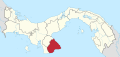
Quebrada de Piedra is a corregimiento in Tolé District, Chiriquí Province, Panama. It has a land area of 98.3 square kilometres (38.0 sq mi) and had a population of 1,127 as of 2010, giving it a population density of 11.5 inhabitants per square kilometre (30/sq mi). Its population as of 1990 was 1,197; its population as of 2000 was 1,209.
Las Lomas is a corregimiento in La Pintada District, Coclé Province, Panama. It has a land area of 86.1 square kilometres (33.2 sq mi) and had a population of 2,072 as of 2010, giving it a population density of 24.1 inhabitants per square kilometre (62/sq mi). It was created by Law 56 of December 5, 2002.
El Picacho is a corregimiento in Olá District, Coclé Province, Panama with a population of 331 as of 2010. Its population as of 1990 was 307; its population as of 2000 was 348.
El Cedro is a corregimiento in Los Pozos District, Herrera Province, Panama with a population of 503 as of 2010. Its population as of 1990 was 543; its population as of 2000 was 539.
Las Guabas is a corregimiento in Los Santos District, Los Santos Province, Panama with a population of 677 as of 2010. Its population as of 1990 was 1,539; its population as of 2000 was 693.
Los Olivos is a corregimiento in Los Santos District, Los Santos Province, Panama with a population of 1,259 as of 2010. Its population as of 1990 was 988; its population as of 2000 was 1,149.
Bahía Honda is a corregimiento in Macaracas District, Los Santos Province, Panama with a population of 646 as of 2010. Its population as of 1990 was 648; its population as of 2000 was 616.
Bajos de Güera is a corregimiento in Macaracas District, Los Santos Province, Panama with a population of 619 as of 2010. Its population as of 1990 was 897; its population as of 2000 was 738.
Espino Amarillo is a corregimiento in Macaracas District, Los Santos Province, Panama with a population of 193 as of 2010. Its population as of 1990 was 254; its population as of 2000 was 209.
Mariabé is a corregimiento in Pedasí District, Los Santos Province, Panama with a population of 319 as of 2010. Its population as of 1990 was 236; its population as of 2000 was 269.
Lajamina is a corregimiento in Pocrí District, Los Santos Province, Panama with a population of 514 as of 2010. Its population as of 1990 was 685; its population as of 2000 was 627.

Paraíso is a corregimiento in Pocrí District, Los Santos Province, Panama with a population of 597 as of 2010. Its population as of 1990 was 574; its population as of 2000 was 593.
El Cacao is a corregimiento in Tonosí District, Los Santos Province, Panama with a population of 1,049 as of 2010. Its population as of 1990 was 778; its population as of 2000 was 932.
El Prado is a corregimiento in Las Palmas District, Veraguas Province, Panama with a population of 1,074 as of 2010. Its population as of 1990 was 4,971; its population as of 2000 was 1,103.
Viguí is a corregimiento in Las Palmas District, Veraguas Province, Panama with a population of 964 as of 2010. It was created by Law 10 of March 7, 1997; this measure was complemented by Law 5 of January 19, 1998 and Law 69 of October 28, 1998. Its population as of 2000 was 929.