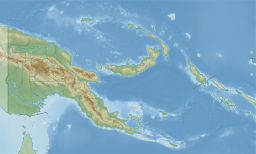
New Britain is the largest island in the Bismarck Archipelago, part of the Islands Region of Papua New Guinea. It is separated from New Guinea by a northwest corner of the Solomon Sea and from New Ireland by St. George's Channel. The main towns of New Britain are Rabaul/Kokopo and Kimbe. The island is roughly the size of Taiwan. While the island was part of German New Guinea, it was named Neupommern . In common with most of the Bismarcks it was largely formed by volcanic processes, and has active volcanoes including Ulawun, Langila, the Garbuna Group, the Sulu Range, and the volcanoes Tavurvur and Vulcan of the Rabaul caldera. A major eruption of Tavurvur in 1994 destroyed the East New Britain provincial capital of Rabaul. Most of the town still lies under metres of ash, and the capital has been moved to nearby Kokopo.

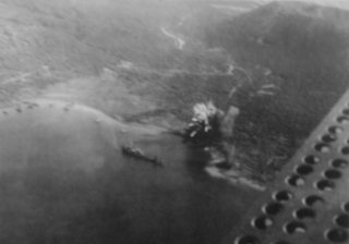
The Battle of the Bismarck Sea took place in the South West Pacific Area (SWPA) during World War II when aircraft of the U.S. Fifth Air Force and the Royal Australian Air Force (RAAF) attacked a Japanese convoy carrying troops to Lae, New Guinea. Most of the Japanese task force was destroyed, and Japanese troop losses were heavy.

The Battle of Rabaul, also known by the Japanese as Operation R, an instigating action of the New Guinea campaign, was fought on the island of New Britain in the Australian Territory of New Guinea, from 23 January into February 1942. It was a strategically significant defeat of Allied forces by Japan in the Pacific campaign of World War II, with the Japanese invasion force quickly overwhelming the small Australian garrison, the majority of which was either killed or captured. Hostilities on the neighbouring island of New Ireland are usually considered to be part of the same battle. Rabaul was significant because of its proximity to the Japanese territory of the Caroline Islands, site of a major Imperial Japanese Navy base on Truk.

The Bougainville campaign was a series of land and naval battles of the Pacific campaign of World War II between Allied forces and the Empire of Japan, named after the island of Bougainville. It was part of Operation Cartwheel, the Allied grand strategy in the South Pacific. The campaign took place in the Northern Solomons in two phases. The first phase, in which American troops landed and held the perimeter around the beachhead at Torokina, lasted from November 1943 through November 1944.

Operation Chronicle was the Allied invasion of Woodlark and Kiriwina Islands, in the South West Pacific, during World War II. The operation was a subordinate action that formed part of the wider Operation Cartwheel, the advance towards Rabaul. An early planning name for this operation was Operation Coronet. Preliminary actions commenced on 23–24 June 1943 when small reconnaissance parties were landed on both islands. The main operation was executed without opposition on 30 June 1943. Around 16,800 personnel took part, divided into two forces. The United States Army provided the majority of ground troops, which were supported by a United States Marine Corps defense battalion as well as U.S. and Australian aircraft and naval vessels.

The New Guinea campaign of the Pacific War lasted from January 1942 until the end of the war in August 1945. During the initial phase in early 1942, the Empire of Japan invaded the Australian-administered Mandated Territory of New Guinea and the Australian Territory of Papua and overran western New Guinea, which was a part of the Netherlands East Indies. During the second phase, lasting from late 1942 until the Japanese surrender, the Allies—consisting primarily of Australian forces—cleared the Japanese first from Papua, then the Mandate and finally from the Dutch colony.
The New Britain campaign was a World War II campaign fought between Allied and Imperial Japanese forces. The campaign was initiated by the Allies in late 1943 as part of a major offensive which aimed to neutralise the important Japanese base at Rabaul, the capital of New Britain, and was conducted in two phases between December 1943 and the end of the war in August 1945.
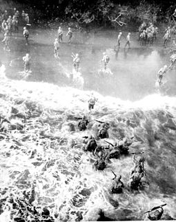
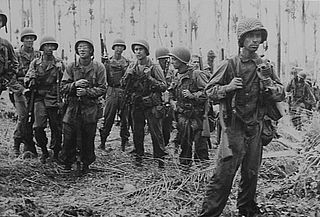
The Battle of Cape Gloucester was fought in the Pacific theater of World War II between Japanese and Allied forces on the island of New Britain, Territory of New Guinea, between 26 December 1943 and 16 January 1944. Codenamed Operation Backhander, the US landing formed part of the wider Operation Cartwheel, the main Allied strategy in the South West Pacific Area and Pacific Ocean Areas during 1943–1944. It was the second landing the US 1st Marine Division had conducted during the war thus far, after Guadalcanal. The objective of the operation was to capture the two Japanese airfields near Cape Gloucester that were defended by elements of the Japanese 17th Division.

The Gazelle Peninsula is a large peninsula in northeastern East New Britain, Papua New Guinea located on the island of New Britain within the Bismarck Archipelago, situated in the southwestern Pacific Ocean. The Rabaul caldera is located on the northern tip of the peninsula. Upon the Gazelle Peninsula are the Baining Mountains, of which the highest point is Mount Sinewit at 2,063 metres (6,768 ft). The Gazelle Peninsula houses Vulcan Crater and Mount Tavurvur, both of which conducted volcanic activity in the 20th and 21st centuries and have provided extremely fertile soils. The body of the Gazelle Peninsula is about 80 kilometers. The southern isthmus upon which the Gazelle Peninsula is connected to the main body of East New Britain is reduced to about 32 kilometers.

The Battle of Arawe was fought between Allied and Japanese forces during the New Britain campaign of World War II. The battle formed part of the Allied Operation Cartwheel, and had the objective of serving as a diversion before a larger landing at Cape Gloucester in late December 1943. The Japanese military was expecting an Allied offensive in western New Britain, and was reinforcing the region at the time of the Allied landing in the Arawe area on 15 December 1943. The Allies secured Arawe after about a month of intermittent fighting with the outnumbered Japanese force.

The Landings at Cape Torokina, also known as Operation Cherryblossom, took place at the beginning of the Bougainville campaign in World War II. The amphibious landings were carried out by elements of the United States Marine Corps in November 1943 on Bougainville Island in the South Pacific, as part of Allied efforts to advance towards the main Japanese base around Rabaul under Operation Cartwheel. Coming in the wake of Allied successes at Guadalcanal and in the central Solomons, the landings were intended to secure a beachhead with the purpose of establishing several bases from which to project air and naval power closer towards Rabaul, in an effort to neutralize the large Japanese force that had been established there.

Simpson Harbour is a sheltered harbour of Blanche Bay, on the Gazelle Peninsula in the extreme north of New Britain. The harbour is named after Captain Cortland Simpson, who surveyed the bay while in command of HMS Blanche in 1872. The former capital city of Rabaul is on its shores.
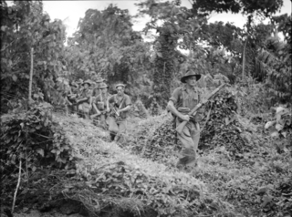
The Battle of Wide Bay–Open Bay was a battle during the New Britain campaign of the Second World War. Following the arrival of the Australians on New Britain in late 1944, replacing the US garrison on the island, they began a limited offensive against the Japanese forces on the island. Pushing east from the positions previously captured by the US troops earlier in the year, after landing at Jacquinot Bay on the southern coast in November, the Australians began advancing across the island towards the Gazelle Peninsula, where they sought to isolate the numerically superior Japanese garrison. This advance was effected along two axes: Cape Hoskins to Open Bay on the northern coast, and Jacquinot Bay to Wide Bay on the southern. Once the Australians had secured a line across the island between Wide Bay and Open Bay in March and April 1945, the fighting on New Britain died down as the Australians sought to contain the larger Japanese garrison while limiting their own casualties. This situation lasted until the end of the war in August 1945.

The Landing at Jacquinot Bay was an Allied amphibious operation undertaken on 4 November 1944 during the New Britain Campaign of World War II. The landing was conducted as part of a change in responsibility for Allied operations on New Britain. The Australian 5th Division, under Major General Alan Ramsay, took over from the US 40th Infantry Division, which was needed for operations in the Philippines. The purpose of the operation was to establish a logistics base at Jacquinot Bay on the south coast of New Britain to support the 5th Division's planned operations near the major Japanese garrison at Rabaul.
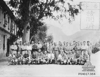
The 2/22nd Battalion was an infantry battalion of the Australian Army. Raised as part of the Second Australian Imperial Force for service during World War II, the battalion formed part of the 23rd Brigade, attached to the 8th Division. It was captured by the Japanese during the Battle of Rabaul in 1942. After being captured, the battalion was not re-raised and a large number of its personnel died in captivity; those that did not were returned to Australia at the end of the war in 1945.

Operation I-Go was an aerial counter-offensive launched by Imperial Japanese forces against Allied forces during the Solomon Islands and New Guinea Campaigns in the Pacific Theater of World War II. Taking place from 1–16 April 1943, during the operation, Japanese aircraft – primarily from Imperial Japanese Navy units under the command of Admirals Isoroku Yamamoto and Jinichi Kusaka – attacked Allied ships, aircraft, and land installations in the southeast Solomon Islands and New Guinea. The goal of the operation was to halt the Allied offensives in New Guinea and the Solomons and to give Japan time to prepare a new set of defenses in response to recent defeats to the Allies in the Battle of Guadalcanal and in New Guinea at Buna–Gona, Wau, and the Bismarck Sea.

Ataliklikun Bay is a bay of East New Britain Province, Papua New Guinea, opening into the Bismarck Sea. It is located in the northern part of New Britain, south-west of Lassul Bay and to the west of Cape Lambert and Rabaul. Urara Island is located in the northern part of the bay. The Raulavat plantation lies in the eastern part of its 25-mile shoreline. The villagers along the shore reportedly speak the Minigir language and the Masava dialect of Tolai. The United States Hydrographic Office said "a reef awash, about 200 yards long east and west, with 15 and 19 fathoms around, on which the steamer Seestem struck in 1909, lies in the south-west part of Ataliklikun Bay."
Toshiharu Sakigawa was a Japanese lieutenant colonel. He is best known for leading a mechanized unit in January 1942, during World War II in which he attacked the Australians on the north coast of New Britain at Rabaul and Ataliklikun Bay during the Battle of Rabaul.
The Warangoi River also known as the Adler River, is a river located in the eastern part of the Gazelle Peninsula in the north-eastern part of New Britain, Papua New Guinea. It flows past the village of Warangoi and out into the Warangoi Bay. It played a part in the Battle of Rabaul early in 1942. Lieutenant Colonel Ishiro Kuwada's men of the 3rd Infantry Battalion captured at least 200 Australian men between the Warangoi River and Vunakanau. Virgin rainforest lies along the river basin.
Rabaul is a town in Eastern New Britain, Papua New Guinea. Japanese forces landed on Rabaul on 23 February 1942, capturing it in February of that year. The former Australian territory was transformed into a major Japanese naval and air installation. The Japanese heavily relied on it, and used it as a launching point for Japanese reinforcements to New Guinea and Guadalcanal. Throughout the Solomons Campaign, neutralizing Rabaul became the primary objective of the Allied effort in the Solomons.