
Amersham is a market town and civil parish in Buckinghamshire, England, in the Chiltern Hills, 27 miles (43 km) northwest of central London, 15 miles (24 km) south-east of Aylesbury and 9 miles (14 km) north-east of High Wycombe. Amersham is part of the London commuter belt.
High Wycombe, often referred to as Wycombe, is a market town in Buckinghamshire, England. Lying in the valley of the River Wye surrounded by the Chiltern Hills, it is 29 miles (47 km) west-northwest of Charing Cross in London, 13 miles (21 km) south-southeast of Aylesbury, 23 miles (37 km) southeast of Oxford, 15 miles (24 km) northeast of Reading and 8 miles (13 km) north of Maidenhead.

Aylesbury is the county town of Buckinghamshire, South East England. It is home to the Roald Dahl Children's Gallery and the Waterside Theatre. It is located in central Buckinghamshire, midway between High Wycombe and Milton Keynes.

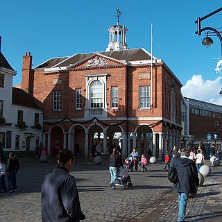
Chesham is a market town and civil parish in Buckinghamshire, England, United Kingdom 11 miles (18 km) south-east of the county town of Aylesbury, 25.8 miles (41.5 km) north-west of central London, and part of the London commuter belt. It is in the Chess Valley, surrounded by farmland. The earliest records of Chesham as a settlement are from the second half of the 10th century, although there is archaeological evidence of people in this area from around 8000 BC. Henry III granted a royal charter for a weekly market in 1257.

The Chiltern Hills are a chalk escarpment in England northwest of London, covering 660 square miles (1,700 km2) across Oxfordshire, Buckinghamshire, Hertfordshire, and Bedfordshire, stretching 45 miles (72 km) from Goring-on-Thames in the southwest to Hitchin in the northeast. The hills are 12 miles (19 km) at their widest.

Wendover is a town and civil parish at the foot of the Chiltern Hills in Buckinghamshire, England. It is situated at the point where the main road across the Chilterns between London and Aylesbury intersects with the once important road along the foot of the Chilterns. The town is some 35 miles (56 km) north west of London and 5 miles (8 km) south east of Aylesbury.
The City of Milton Keynes is a unitary authority area with both borough and city status, in Buckinghamshire. It is the northernmost district of the South East England Region. The borough abuts Bedfordshire, Northamptonshire and the remainder of Buckinghamshire.

Little Chalfont is a village and civil parish in south-east Buckinghamshire, England. It is one of a group of villages known collectively as The Chalfonts, which also comprises Chalfont St Giles and Chalfont St Peter. Little Chalfont is located around 2 miles (3.2 km) east of Amersham and 21.9 miles (35.2 km) northwest of Charing Cross, central London.

Bletchley is a constituent town of Milton Keynes, Buckinghamshire, England. It is situated in the south-west of Milton Keynes, and is split between the civil parishes of Bletchley and Fenny Stratford and West Bletchley.

Latimer is a village that sits on the border between Buckinghamshire and Hertfordshire, England. In 2013, the civil parish of Latimer was renamed, Latimer and Ley Hill. The parish, forming part of the Buckinghamshire district of Chiltern, includes the villages of Latimer, Ley Hill and Tyler's Hill.
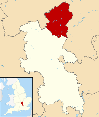
Chiltern District was one of four local government districts of Buckinghamshire in south central England from 1974 to 2020. It was named after the Chiltern Hills on which the region sits.
Chorleywood is both a village and a civil parish in the Three Rivers District, Hertfordshire, on the border with Buckinghamshire, approximately 20 miles (32 km) northwest of Charing Cross. The village is adjacent to the Chiltern Hills Area of Outstanding Natural Beauty and is part of the London commuter belt included in the government-defined Greater London Urban Area. Chorleywood was historically part of the parish of Rickmansworth, becoming a separate ecclesiastical parish in 1845 and a separate civil parish in 1898. The population of the parish was 11,286 at the 2011 census.
Thurcaston is a village and former civil parish, now in the parish of Thurcaston and Cropston, in the Charnwood district, in Leicestershire, England. It was the home of Bishop Hugh Latimer.

Chesham and Amersham is a parliamentary constituency in Buckinghamshire, South East England, represented in the House of Commons by Sarah Green, a Liberal Democrat elected at a 2021 by-election.

Ley Hill is a Chiltern village on the Buckinghamshire/Hertfordshire border in south-east England, near the town of Chesham. It is part of the civil parish of Latimer and Ley Hill, and comes under Chiltern District Council in the County of Buckinghamshire. Ley Hill lies in the Chiltern Hills and is contiguous with Botley.
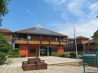
Chiltern District Council in Buckinghamshire, England was elected every four years from 1973 until 2020. Since the last boundary changes in 2003, 40 councillors were elected from 25 wards.
Tylers Hill is a hamlet in the civil parish of Latimer and Ley Hill, in the Buckinghamshire district, in the ceremonial county of Buckinghamshire, England. It is located to the east of Chesham, near Botley. The name is derived from the historic tile making industry in the region. In 1888, a bricklayer's son named Elbourn discovered a buried earthenware vessel filled with gold coins. Although many were dispersed among local children and bystanders, some were eventually taken by the police for the Treasury. The coins were dated to the reigns of Elizabeth I, James I, and Charles I, suggesting they had been buried around the time of the English Civil War.

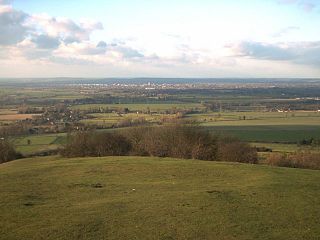
Bacombe and Coombe Hills is a 76.4-hectare (189-acre) biological Site of Special Scientific Interest in Upper Bacombe in Buckinghamshire. Bacombe Hill was formerly owned by Buckinghamshire County Council, which transferred it to Berkshire, Buckinghamshire and Oxfordshire Wildlife Trust in 2014. Coombe Hill is owned by the National Trust.
The Aylesbury Vale is a geographical region in Buckinghamshire, England, which is bounded by the City of Milton Keynes and West Northamptonshire to the north, Central Bedfordshire and the Borough of Dacorum (Hertfordshire) to the east, the Chiltern Hills to the south and South Oxfordshire to the west. It is named after Aylesbury, the county town of Buckinghamshire. Winslow and Buckingham are among the larger towns in the vale.

