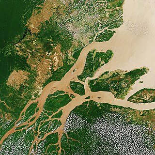
The Amazon River in South America is the largest river by discharge volume of water in the world, and the longest or second-longest river system in the world, a title which is disputed with the Nile.

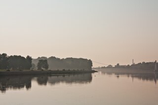
The Rhine is one of the major European rivers. The river begins in the Swiss canton of Graubünden in the southeastern Swiss Alps. It forms part of the Swiss-Liechtenstein, Swiss-Austrian, and Swiss-German borders. After that the Rhine defines much of the Franco-German border, after which it flows in a mostly northerly direction through the German Rhineland. Finally in Germany, the Rhine turns into a predominantly westerly direction and flows into the Netherlands where it eventually empties into the North Sea. It drains an area of 9,973 km2 and its name derives from the Celtic Rēnos. There are also two German states named after the river, North Rhine-Westphalia and Rhineland-Palatinate.
The Drava or Drave, historically known as the Dravis or Dravus, is a river in southern Central Europe. With a length of 710km, or 724km, if the length of its Sextner Bach source is added, it is the fifth or sixth longest tributary of the Danube, after the Tisza, Sava, Prut, Mureș and likely Siret. The Drava drains an area of about 40,154 square kilometers. Its mean annual discharge is seasonally 500m³/s to 670m³/s. Its source is near the market town of Innichen, in the Puster Valley of South Tyrol, Italy. The river flows eastwards through East Tyrol and Carinthia in Austria into the Styria region of Slovenia. It then turns southeast, passing through northern Croatia and, after merging with its main tributary the Mur, forms most of the border between Croatia and Hungary, before it joins the Danube near Osijek, in Croatia.

The Mur or Mura is a river in Central Europe rising in the Hohe Tauern national park of the Central Eastern Alps in Austria with its source at 1,898 m (6,227 ft) above sea level. It is a tributary of the Drava and subsequently the Danube.

The Thaya is a river in Central Europe, the longest tributary to the river Morava. Its drainage basin is 12,772 km2 (4,931 sq mi). Its length is 224 km (139 mi). It meanders from west to east in the border area between Lower Austria (Austria) and South Moravia, though the frontier does not exactly follow the river's course in most parts. Its source is in two smaller rivers, namely the German Thaya and the Moravian Thaya, flowing together at Raabs an der Thaya.

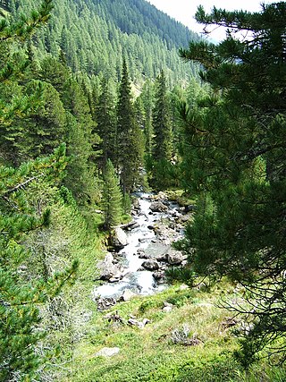
Traun is a river in the Austrian state of Upper Austria. Its source is in the Totes Gebirge mountain range in Styria. It flows through the Salzkammergut area and the lakes Hallstätter See and Traunsee. The Traun is a right tributary of the Danube, which it meets near the city of Linz. Other towns along the river are Bad Aussee, Bad Ischl, Gmunden, Wels and Traun. The Traun is 155.9 km (96.9 mi) long, and has a basin area of 4,257 km2 (1,644 sq mi). Its average discharge at the mouth is 150 m3/s (5,300 cu ft/s).

The Maya is a river in Khabarovsk Krai and Sakha, Russia. It is a right tributary of the Aldan of the Lena basin. The length of the river is 1,053 kilometres (654 mi). The area of its basin 171,000 square kilometres (66,000 sq mi).

The Noric Alps is a collective term denoting various mountain ranges of the Eastern Alps. The name derives from the ancient Noricum province of the Roman Empire on the territory of present-day Austria and the adjacent Bavarian and Slovenian area.
Bezirk Gmunden is a district of the state of Upper Austria in Austria.

The Höttinger Bach is a river of Tyrol, Austria. It is a 4 km (2.5 mi) long left tributary of the Inn in Innsbruck and its entire length lies in the Innsbruck city area.

The Frutz is a river of Vorarlberg, Austria, a tributary of the Rhine.

Vorchdorf is a market town in the district of Gmunden in Upper Austria, Austria, as well as the name of the municipal area ("Gemeinde") that the town and others occupy. As of the 2005 census, the town of Vorchdorf had a population of 7,287 inhabitants.

Alm is a river in the Austrian state of Upper Austria.

The Aist is a river in Upper Austria, a left tributary of the Danube. It drains an area of 636 km2 (246 sq mi).

The Hartbach is a river of Upper Austria, a small, right tributary of the Inn.

The Danube is the second-longest river in Europe, after the Volga in Russia. It flows through Central and Southeastern Europe, from the Black Forest south into the Black Sea. A large and historically important river, it was once a frontier of the Roman Empire. In the 21st century, it connects ten European countries, running through their territories or marking a border. Originating in Germany, the Danube flows southeast for 2,850 km (1,770 mi), passing through or bordering Austria, Slovakia, Hungary, Croatia, Serbia, Romania, Bulgaria, Moldova, and Ukraine. Among the many cities on the river are four national capitals: Vienna, Bratislava, Budapest, and Belgrade. Its drainage basin amounts to 817,000 km² and extends into nine more countries.

The Alamüdün or Alamedin river is a left tributary of the Chu in Northern Kyrgyzstan.
The Debantbach is a stream in East Tyrol, Austria. Its source is west of the Hochschober and north of the Leibnitztörl, below the Debantgrat. At the end of the Debanttal Valley, the Debantbach joins the Gößnitzbach and then flows through the Debanttal and into the Drava at Dölsach. The Debantbach descends a total of 1,890 m (6,200 ft) from its source to its mouth, and it has a total length of 22.3 km (13.9 mi). Its drainage basin is 83.3 km2 (32.2 sq mi). It takes in a total of 48 bodies of water.
