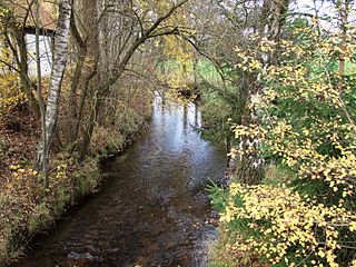
The Brigach is the shorter of two streams that jointly form the river Danube in Baden-Württemberg, Germany. The Brigach has its source at 925 m (3,035 ft) above sea level within St. Georgen in the Black Forest. The Brigach crosses the city Villingen-Schwenningen. 40.4 km (25.1 mi) from the source, the Brigach joins the Breg in Donaueschingen to form the Danube River.

The Pegnitz is a river in Franconia in the German federal state of Bavaria.

The Amper, called the Ammer upstream of the Ammersee, through which it runs, is the largest tributary of the Isar in southern Bavaria, Germany. It flows generally north-eastward, reaching the Isar in Moosburg, about 185 kilometres (115 mi) from its source in the Ammergau Alps, with a flow of 45 m³/s. Including its tributary, Linder, it is 209.5 km (130.2 mi) long. Major tributaries are the Glonn, which rises near Augsburg; the Würm, which is the outflow of Lake Starnberg; and the Maisach.

The Acher is a 53.6-kilometre-long river and right-hand tributary of the Rhine in the county of Ortenau, in the south German state of Baden-Württemberg. It flows in an northwesterly direction from the Black Forest to the Rhine, between the two rivers Rench to the south and the Oos to the north.

The Sulm is a river in the Heilbronn district of Baden-Württemberg, Germany. It is an unnavigable right tributary of the Neckar. It rises in the Löwenstein Mountains and after 26.3 kilometres (16.3 mi) distance and 315 metres (1,033 ft) elevation drop flows into the Neckar at Bad Friedrichshall, near Untereisesheim and Neckarsulm. Its valley together with its tributary valleys is also known as the Weinsberg Valley, after Weinsberg, which is located there. The medieval region of Sulmgau, as well as the city of Neckarsulm, were named for it. The upper valley of the Sulm is a protected area.

The Murr is a river in Baden-Württemberg, Germany, right tributary of the Neckar. The river gave its name to a small town on its banks, Murr, and to the Rems-Murr-Kreis district, which was also named after the river Rems, which runs roughly parallel to the south of the Murr.

Lautertal is a municipality in the district of Coburg in Bavaria in Germany. Near Lautertal, there was between 1952 and 1992 a DECCA-transmitter.

The Swabian Rezat is a 33.3-kilometre-long river in southern Germany (Bavaria). It is the southern, right source river of the Rednitz. It rises in the Franconian Jura hills, near Weißenburg in Bayern. It flows generally north through the towns Weißenburg in Bayern, Ellingen and Pleinfeld. Together with the Franconian Rezat, it forms the Rednitz in Georgensgmünd.

The Itz is a river of Thuringia and Bavaria, Germany.

The Selbitz is a river of Bavaria and Thuringia, Germany.

Effelder is a 17 km (11 mi) tributary river of the Itz in the districts of Sonneberg (Thuringia) and Coburg (Bavaria). It flows into the Froschgrundsee, which is drained by the Itz, near Schönstädt.

Röthen is a river of Thuringia and Bavaria, Germany. It passes through Sonneberg and Neustadt bei Coburg, and flows into the Itz near Rödental.

Eschach is a river of Baden-Württemberg, Germany. It flows into the Neckar south of Rottweil.

Eyach is a river of Baden-Württemberg, Germany. It flows for 50 kilometres. It is a right tributary of the Neckar. It passes through Balingen and Haigerloch, and flows into the Neckar near Starzach.

Glatt is a river of Baden-Württemberg, Germany.

The Lein is a river of Baden-Württemberg, Germany. It is a left tributary of the Kocher. Its source is near Kaisersbach. It passes through Welzheim, Täferrot, Leinzell and Heuchlingen, and flows into the Kocher in Abtsgmünd.

Buxach is a river of Bavaria, Germany.

Gersprenz is a river that starts in the Odenwald, Hesse and flows into the river Main near Aschaffenburg, Bavaria, Germany. Including its source river Mergbach, it is 62.1 km (38.6 mi) long, without the Mergbach it is 51.3 km (31.9 mi) long.
Kaltenmühlbach is a 6.8-kilometre-long (4.2 mi) left tributary of the Waldnaab in the Upper Palatinate in Bavaria, Germany. It rises in the High Thaner Forest and flows to the Waldnaab.

Kieferbach is a river of Tyrol, Austria and Bavaria, Germany. It flows into the Inn near Kiefersfelden.


