Neukirchen, Lower Bavaria

Last updated
Neukirchen
St. Martin Neukirchen.JPG
Church of Saint Martin
DEU Neukirchen (Niederbayern) COA.svg
Location of Neukirchen within Straubing-Bogen district
Neukirchen in SR.svgBogenSteinachSchwarzachRattenbergRainNeukirchenHaselbachHaibachFeldkirchen
Germany adm location map.svg
Red pog.svg
Neukirchen
Bavaria location map.svg
Red pog.svg
Neukirchen
Coordinates: 48°59′N12°46′E / 48.983°N 12.767°E / 48.983; 12.767 Coordinates: 48°59′N12°46′E / 48.983°N 12.767°E / 48.983; 12.767
Country Germany
State Bavaria
Admin. region Niederbayern
District Straubing-Bogen
Municipal assoc. Hunderdorf
Government
   Mayor (202026) Matthias Wallner [1]
Area
  Total24.45 km2 (9.44 sq mi)
Elevation
375 m (1,230 ft)
Population
 (2021-12-31) [2]
  Total1,775
  Density73/km2 (190/sq mi)
Time zone UTC+01:00 (CET)
  Summer (DST) UTC+02:00 (CEST)
Postal codes
94362
Dialling codes 09961
Vehicle registration SR
Website www.neukirchen.net

Neukirchen is a municipality in the district of Straubing-Bogen in Bavaria, Germany. It is located in the Donau-Wald region in the Bavarian Forest.

Contents

Districts

Neukirchen has 65 districts: [3]

  • Angermühl
  • Au
  • Autsdorf
  • Bachersgrub
  • Birkhof
  • Brandlehen
  • Buchaberg
  • Buchamühl
  • Bühel
  • Bühelberg
  • Burkasberg
  • Dießenbach
  • Dießenberg
  • Dörnau
  • Edersberg
  • Feldhof
  • Fremdstuhl
  • Graben
  • Grad
  • Hacka
  • Haggn
  • Hagnberg
  • Hochstraß
  • Höfling
  • Hungerszell
  • Inderbogen
  • Irlach
  • Irlmühle
  • Kager
  • Kreuzhaus
  • Langholz
  • Lehenfeld
  • Lohhof
  • Lohmühl
  • Maulhof
  • Mitterberg
  • Mitterkogl
  • Mitterwachsenberg
  • Neukirchen
  • Niederhofen
  • Notzling
  • Oberkogl
  • Obermühlbach
  • Oberwachsenberg
  • Öd bei Buchamühl
  • Oed bei Reisach
  • Plenthof
  • Prünst
  • Pürgl
  • Radmoos
  • Reisach
  • Rimbach
  • Schelnbach
  • Schickersgrub
  • Seethal
  • Sparr
  • Steg
  • Stippich
  • Taußersdorf
  • Thannerhof
  • Unterkogl
  • Untermühlbach
  • Unterwachsenberg
  • Unterwolfessen

History

Early history

Neukirchen was first mentioned in 1126 in the deed of the monastery Oberalteich under the name Niuenchirichen. Neukirchen belonged to the Rentamt  [ bar; de; es ] Straubing and the regional court Mitterfels of the Electorate of Bavaria.[ citation needed ]

Incorporations

On January 1, 1976, the previously independent municipality Obermühlbach, which had more inhabitants than Neukirchen, incorporated. [4] Dörnau (1979), Birkhof and Rimbach (1980) were reclassified from Hunderdorf to Neukirchen. [5]

Population

Government

The Mayor of Neukirchen since March 2008 is Rudolf Seidenader.[ citation needed ]

Landmarks

Infrastructure

Education

There are the following facilities:

Roadways

Neukirchen is located on State Road 2139. In 2017, a Bavaria-wide pilot project to measure the volume of motorcycles was carried out by the Bavarian Police Department. Following the successful completion of the pilot project, the Bavarian Ministry of the Interior decided at the beginning of 2018 to allow the use of noise displays nationwide. Neukirchen, in cooperation with the neighboring municipality of St. Englmar and initiated by council member Matthias Wallner, is taking on a pioneering role in Bavaria in the fight against motorcycle noise. [7]

Related Research Articles

<span class="mw-page-title-main">Bavaria</span> State in Germany

Bavaria, officially the Free State of Bavaria, is a state in the south-east of Germany. With an area of 70,550.19 km2 (27,239.58 sq mi), Bavaria is the largest German state by land area, comprising roughly a fifth of the total land area of Germany. With over 13 million inhabitants, it is the second largest German state in terms of population only to North Rhine-Westphalia, but due to its large size its population density is below the German average. Bavaria's main cities are Munich, Nuremberg, and Augsburg.

<span class="mw-page-title-main">Bogen, Germany</span> Town in Bavaria, Germany

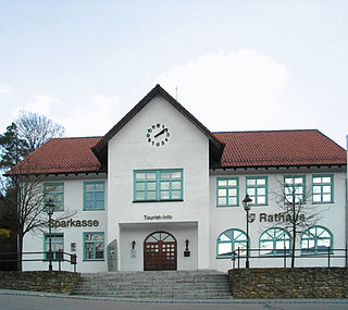
Bogen is a town in the district of Straubing-Bogen in Bavaria, Germany. It has a population of 10,105. Bogen is located between the southern slopes of the Bavarian Forest and the River Danube. The town lies at the foot of the Bogenberg, a hill immediately on the Danube. The pilgrimage church of the Assumption of the Virgin Mary on the Bogenberg is the destination of one of the oldest pilgrimages for Saint Mary in Bavaria.

<span class="mw-page-title-main">Altomünster</span> Municipality in Bavaria, Germany

Altomünster is a municipality in the district of Dachau in Bavaria in Germany.

<span class="mw-page-title-main">Vierkirchen</span> Municipality in Bavaria, Germany

Vierkirchen is a municipality in the district of Dachau in Bavaria in Germany.

<span class="mw-page-title-main">Egmating</span> Municipality in Bavaria, Germany

Egmating is a community in the Upper Bavarian district of Ebersberg in Germany. It is a member of the administrative community (Verwaltungsgemeinschaft) of Glonn.

<span class="mw-page-title-main">Steinhöring</span> Municipality in Bavaria, Germany

Steinhöring is a community in the Upper Bavarian district of Ebersberg.

<span class="mw-page-title-main">Wallgau</span> Municipality in Bavaria, Germany

Wallgau is a municipality in the district of Garmisch-Partenkirchen, in Bavaria, Germany.

<span class="mw-page-title-main">Riedbach</span> Municipality in Bavaria, Germany

Riedbach is a municipality in the district of Haßberge in Bavaria in Germany. It is situated 20 km northeast of Schweinfurt and 8 km north of Haßfurt.

<span class="mw-page-title-main">Eching am Ammersee</span> Municipality in Bavaria, Germany

Eching am Ammersee is a municipality in the district of Landsberg in Bavaria in Germany. It has a size of 6.15km2.

<span class="mw-page-title-main">Neuburg am Inn</span> Municipality in Bavaria, Germany

Neuburg am Inn is a municipality in the district of Passau in Bavaria in Germany.

<span class="mw-page-title-main">Kollnburg</span> Municipality in Bavaria, Germany

Kollnburg is a municipality in the district of Regen, in Bavaria, Germany. A part of the municipal area, including the parish village of the same name, is a state-approved resort.

<span class="mw-page-title-main">Altenthann</span> Municipality in Bavaria, Germany

Altenthann is a village and municipality in the district of Regensburg in Bavaria in Germany.

<span class="mw-page-title-main">Großkarolinenfeld</span> Municipality in Bavaria, Germany

Großkarolinenfeld is a municipality in the district of Rosenheim in Bavaria in Germany.

<span class="mw-page-title-main">Zeilarn</span> Municipality in Bavaria, Germany

Zeilarn is a municipality in the district of Rottal-Inn in Bavaria, Germany.

<span class="mw-page-title-main">Mallersdorf-Pfaffenberg</span> Municipality in Bavaria, Germany

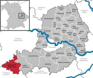
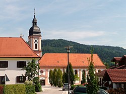
Mallersdorf-Pfaffenberg is a municipality in the district of Straubing-Bogen in Bavaria, Germany and has around 7000 inhabitants.

<span class="mw-page-title-main">Mitterfels</span> Municipality in Bavaria, Germany

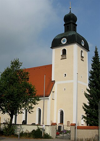
Mitterfels is a municipality in the district of Straubing-Bogen in Bavaria, Germany. It is the head of the Verwaltungsgemeinschaft Mitterfels.

<span class="mw-page-title-main">Inzell</span> Place in Bavaria, Germany

Inzell is a municipality in the district of Traunstein in Bavaria, Germany. It is known for the Eisstadion Inzell, an outdoor artificial ice rink that has been used for many international speed skating championships. It is now an indoor oval.

<span class="mw-page-title-main">Obernzell</span> Municipality in Bavaria, Germany

Obernzell is a municipality in the district of Passau in Bavaria in Germany.

The village of Mittbach is a south-western part of the market town of Isen in the Upper Bavarian district of Erding, Germany. Until the district reform, which came into force on 1 July 1972, the municipality of Mittbach belonged to the district of Wasserburg am Inn. Since then it has belonged to the district of Erding until its dissolution in 1978.

<span class="mw-page-title-main">Weinzierlein</span> Ortsteil of Zirndorf in Bavaria, Germany

Weinzierlein is a village in the town of Zirndorf in the Central Franconian district of Fürth in Bavaria, Germany.

References

  1. Liste der ersten Bürgermeister/Oberbürgermeister in kreisangehörigen Gemeinden, Bayerisches Landesamt für Statistik, 15 July 2021.
  2. "Tabelle 12411-003r Fortschreibung des Bevölkerungsstandes: Gemeinden, Stichtag" (in German). Bayerisches Landesamt für Statistik. June 2022.
  3. Gemeinde Neukirchen in the location database of the Bavarian State Library Online . Bavarian State Library, retrieved 29 October 2017
  4. Historisches Gemeindeverzeichnis für die Bundesrepublik Deutschland : Namens-, Grenz- und Schlüsselnummernänderungen bei Gemeinden, Kreisen und Regierungsbezirken vom 27.5.1970 bis 31.12.1982 (in German). Germany (West). Statistisches Bundesamt. Stuttgart: Kohlhammer. 1983. ISBN   3170032631. OCLC   10562096.{{cite book}}: CS1 maint: others (link)
  5. "Die Gemeinden Bayerns nach dem Gebietsstand 25 May 1987. Die Einwohnerzahlen der Gemeinden Bayerns und die Änderungen im Besitzstand und Gebiet von 1840 bis 1987." In: Bavarian State Office of Statistics and Data Processing: Contributions to the statistics of Bavaria. Munich 1991, p. 70–72
  6. "Grundschule Neukirchen". Schuldatenbank des Bayerischen Staatsministeriums für Bildung und Kultus, Wissenschaft und Kunst (in German). Retrieved 2019-04-21.
  7. "Motorradlärm: "Es gibt immer ein paar Unbelehrbare"". idowa.de (in German). 2017-05-22. Retrieved 2019-04-23.