Mallersdorf-Pfaffenberg

Last updated

Mallersdorf-Pfaffenberg
Kloster Mallersdorf.JPG
DEU Mallersdorf-Pfaffenberg COA.svg
Coat of arms
Location of Mallersdorf-Pfaffenberg within Straubing-Bogen district
Mallersdorf-Pfaffenberg in SR.svg
Germany adm location map.svg
Red pog.svg
Mallersdorf-Pfaffenberg
Bavaria location map.svg
Red pog.svg
Mallersdorf-Pfaffenberg
Coordinates: 48°46′N12°14′E / 48.767°N 12.233°E / 48.767; 12.233 Coordinates: 48°46′N12°14′E / 48.767°N 12.233°E / 48.767; 12.233
Country Germany
State Bavaria
Admin. region Niederbayern
District Straubing-Bogen
Subdivisions9 Ortsteile
Government
   Mayor (202026) Christian Dobmeier [1] (CSU)
Area
  Total72.61 km2 (28.03 sq mi)
Elevation
411 m (1,348 ft)
Population
 (2020-12-31) [2]
  Total6,932
  Density95/km2 (250/sq mi)
Time zone UTC+01:00 (CET)
  Summer (DST) UTC+02:00 (CEST)
Postal codes
84066
Dialling codes 08772
Vehicle registration SR
Website www.mallersdorf-pfaffenberg.de

Mallersdorf-Pfaffenberg (Central Bavarian : Mollaschdorf-Pfoffaberg) is a municipality in the district of Straubing-Bogen in Bavaria, Germany and has around 7000 inhabitants.

Contents

Mallersdorf-Pfaffenberg is located in the heart of Bavaria in the south of Germany. The medieval cities Regensburg and Landshut are within a 30 km radius and even the major cities Munich (München) and Nürnberg are just around 100 km away.

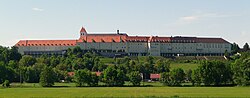
The town is well known for the Mallersdorf Abbey, which exists since the 12th century. The Franciscan order of the "Mallersdorfer Schwestern" is busy around the world. Also Pope Benedict XVI enjoyed his vacations here.

Coat of arms

History

The history of the village Mallersdorf goes back to the Roman times, because the first castle, named "Madilhardisdorf" had been established on the foundation of a Roman fort. The name goes back to Mathilde von Lupburg, the 9th abbess of the Reichsstift Niedermünster in Regensburg who owned vast ?. During the Carolingian's time Mallersdorf belonged to the county of Kirchberg. The counts Heinrich and Ernst donated a cloister in 1107, which was first mentioned in a document in 1129, with the confirmation of the donation by emperor Lothar III. The Latin school, which was controlled by Benedictine monks in the cloister of Mallersdorf on the Johannisberg, operated there from 1109 to 1803. Mallersdorf gained a great reputation in the scientific area due to its large library. The honorary title "sedes sapientiae" (seat of wisdom) testifies this position. In the course of the Säkularisation the cloister was converted into a farm with brewery. The library, as well as valuable sacred objects, was brought to Munich. The cloister had a resurgence in 1869 as a franziscan order, the "Sisters of Mallersdorf"( established her mother's house there.)

In 1972 the places Mallersdorf, Pfaffenberg, Holztraubach, Ascholtshausen, Oberellenbach, Oberlindhart were united to the market Mallersdorf-Pfaffenberg. The municipalities of Niederlindhart, Haselbach and Upfkofen came on 1 January 1978. On 1 July 1972 Mallersdorf lost the District's Office and came to the administrative district Straubing-Bogen. Therefore the sign MAL disappeared mainly from the streets.

Partnership

Mallersdorf-Pfaffenberg established town partnerships with Paderno del Grappa in Italy and Jedlicze in Poland. Godparenthood[ clarification needed ] was taken in 1985 for the expelled Sudeten-German from the village of Krajková, formerly Gossengrun, in present-day Sokolov District.

Places of interest

Cloister of Mallersdorf

The franciscan cloister of Mallersdorf which pursues a secondary school is built on a hill above the idyllic Labertal (Laber-valley). The basilica affiliated to the cloister was begun in 1109 and received her today's rococo equipment in the middle of the 18th century. In the parish church Saint Johannes there is a high altar of Ignaz Günther. The order was founded by Paul Josef Nardini, who was venerated at 19 December 2005 and beatified at 22 October 2006 by Pope Benedict XVI at the cathedral at Speyer, Germany.

Jewish monument

Near Pfaffenberg is a Jewish monument. It was established in 1947 and was financed by donations of Jewish inhabitants of the region. It marks a tomb for 67 prisoners who had been force-marched from the concentration camp Buchenwald and were shot by German soldiers, before they could be freed by the allies.

Bonifatius-Statue

Castle Oberellenbach

Castle Oberhaselbach

Education

Public facilities

Related Research Articles

Abensberg Place in Bavaria, Germany

Abensberg is a town in the Lower Bavarian district of Kelheim, in Bavaria, Germany, lying around 30 km southwest of Regensburg, 40 km east of Ingolstadt, 50 northwest of Landshut and 100 km north of Munich. It is situated on the river Abens, a tributary of the Danube.

Cham is a Landkreis (district) in Bavaria, Germany. It is bounded by the districts of Regen, Straubing-Bogen, Regensburg and Schwandorf and by the Czech Plzeň Region.

Deggendorf is a Landkreis (district) in Bavaria, Germany. It is bordered by the districts of Regen, Freyung-Grafenau, Passau, Rottal-Inn, Dingolfing-Landau and Straubing-Bogen.

Regen is a Landkreis (district) in Bavaria, Germany. It is bounded by the districts of Freyung-Grafenau, Deggendorf, Straubing-Bogen and Cham, and by the Czech Republic.

Regensburg is a Landkreis (district) in Bavaria, Germany. It is bounded by the districts of Schwandorf, Cham, Straubing-Bogen, Kelheim and Neumarkt. The city of Regensburg is enclosed by it, but is not part of the district; nonetheless it is its administrative seat.

Straubing-Bogen is a Landkreis (district) in the eastern part of Bavaria, Germany. Neighboring districts are Cham, Regen, Deggendorf, Dingolfing-Landau, Landshut and Regensburg. The independent town of Straubing is surrounded by the district. The seat of the government of the district (Landratsamt) is located in Straubing.

Bogen, Germany Place in Bavaria, Germany

Bogen is a town in the district of Straubing-Bogen in Bavaria, Germany. It has a population of 10,105. Bogen is located between the southern slopes of the Bavarian Forest and the River Danube. The town lies at the foot of the Bogenberg, a hill immediately on the Danube. The pilgrimage church of the Assumption of the Virgin Mary on the Bogenberg is the destination of one of the oldest pilgrimages for Saint Mary in Bavaria. This was also the seat of power of the Counts of Bogen, who died out in 1242, before the fief passed over to the Wittelsbachs. Since 1958, the German Army has been based at the Graf-Aswin-Kaserne in Bogen. The barracks are home to army engineers and are used for training medics.

Geiselhöring Place in Bavaria, Germany

Geiselhöring is a town in the Straubing-Bogen district, in Bavaria, Germany. It is situated 14 km southwest of Straubing, and 30 km southeast of Regensburg.

Außernzell Place in Bavaria, Germany

Außernzell is a municipality in the district of Deggendorf in Bavaria in Germany. It is part of the municipal union of Schöllnach.

Bayerbach bei Ergoldsbach Place in Bavaria, Germany

Bayerbach is a municipality in the district of Landshut in Bavaria in Germany.

Altenthann Place in Bavaria, Germany

Altenthann is a village and municipality in the district of Regensburg in Bavaria in Germany.

Aiterhofen Place in Bavaria, Germany

Aiterhofen is a municipality in the district of Straubing-Bogen in Bavaria, Germany.

Konzell Place in Bavaria, Germany

Konzell is a municipality in the district of Straubing-Bogen in Bavaria, Germany.

Laberweinting Place in Bavaria, Germany

Laberweinting is a municipality in the district of Straubing-Bogen in Bavaria, Germany.

Mitterfels Place in Bavaria, Germany

Mitterfels is a municipality in the district of Straubing-Bogen in Bavaria, Germany. It is the head of the Verwaltungsgemeinschaft Mitterfels.

Oberschneiding Place in Bavaria, Germany

Oberschneiding is a municipality in the district of Straubing-Bogen in Bavaria, Germany.

Schwarzach, Lower Bavaria Place in Bavaria, Germany

Schwarzach is a market town and municipality in the district of Straubing-Bogen in Bavaria, Germany. It is the seat of the municipal association Schwarzach. The town is an officially recognised Resort town.

Konnersreuth Place in Bavaria, Germany

Konnersreuth is a municipality in the district of Tirschenreuth in Bavaria, Germany. It is situated in the northeast foothills of the Steinwald mountains between the Fichtelgebirge mountains and the Upper Palatinate Forest, close to the Czech border. The village is best known as the home of the 20th-century Catholic stigmatist Therese Neumann.

Haselbach, Bavaria Place in Bavaria, Germany

Haselbach is a municipality in the district of Straubing-Bogen in Bavaria, Germany.

Neukirchen, Lower Bavaria Place in Bavaria, Germany

Neukirchen is a municipality in the district of Straubing-Bogen in Bavaria, Germany. It is located in the Donau-Wald region in the Bavarian Forest.

References

  1. Liste der ersten Bürgermeister/Oberbürgermeister in kreisangehörigen Gemeinden, Bayerisches Landesamt für Statistik, 15 July 2021.
  2. "Tabellenblatt "Daten 2", Statistischer Bericht A1200C 202041 Einwohnerzahlen der Gemeinden, Kreise und Regierungsbezirke". Bayerisches Landesamt für Statistik und Datenverarbeitung (in German). June 2021.