Simbach is a market town and municipality in the district of Dingolfing-Landau, Bavaria, Germany. As of 2020, it had a population of around 4,000 and an area of 51.23 km².
Bichl is a municipality in the district of Bad Tölz-Wolfratshausen in Bavaria, Germany. It is located at 47°43′N11°25′E, and has about 2000 residents. The village first appears in documents from 1048.

Grafrath is a municipality in the district of Fürstenfeldbruck in Bavaria in Germany. It takes its name from Saint Rasso (Ratho), who was a count (Graf) who founded a Benedictine abbey here in the 10th century.

Schäftlarn is a municipality in the district of Munich in Bavaria in Germany. It consists of the villages Ebenhausen, Hohenschäftlarn, Kloster Schäftlarn, Neufahrn and Zell. The river Isar runs through it. A human settlement with the name "Schäftlarn" does not exist.

Feldkirchen is a municipality in the district of Munich, Bavaria, Germany. It is located 10 km east of Munich and has 5,987 inhabitants. Feldkirchen was first mentioned in a document dated 853.

Etzelwang is a municipality in the district of Amberg-Sulzbach in Bavaria in Germany.
Außernzell is a municipality in the district of Deggendorf in Bavaria in Germany. It is part of the municipal union of Schöllnach.

Pastetten is a municipality in the district of Erding in Bavaria in Germany. It is a rural municipality in the south of the district. The town was founded about one thousand years ago along the road from Swabia to Erding.
Neuschönau is a municipality in the district of Freyung-Grafenau, in the Lower Bavaria region of Bavaria, in Germany.
Bad Bayersoien is a German municipality in the district of Garmisch-Partenkirchen, in Bavaria.

Unterammergau is a municipality in the district of Garmisch-Partenkirchen, in Bavaria, Germany. It is the site of the 11th-century Chapel of St Leonhard, patron saint of horses, which is the terminus of the annual Leonhardritt and Blessing of the Animals.
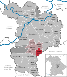
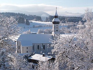
Wildenberg is a municipality in the district of Kelheim in Bavaria in Germany.

Bayerbach is a municipality in the district of Landshut in Bavaria in Germany.
Aying is a municipality in the district of Munich in Bavaria, Germany. It is known for the Ayinger Brewery.

Haarbach is a municipality in the district of Passau in Bavaria in Germany.

Rottenbuch is a municipality in the Weilheim-Schongau district, in Bavaria, Germany. It is the site of Rottenbuch Abbey church.

Steingaden is a town and municipality in the Weilheim-Schongau district of Upper Bavaria, Germany. It is the site of the 12th-century Steingaden Abbey and the Wies Church, a UNESCO World Heritage Site.
Ustersbach is a municipality in the district of Augsburg in Bavaria in Germany. It is situated approx. 20 km west of Augsburg

Schonstett is a municipality in the district of Rosenheim in Bavaria in Germany.
Theres is a municipality on the river Main, in the district of Haßberge in Bavaria in Germany. It was once the site of Theres Abbey, but the church was demolished in 1809.


