Leše, Prevalje

Last updated
Leše
Slovenia location map.svg
Red pog.svg
Leše
Location in Slovenia
Coordinates: 46°31′49.91″N14°54′22.62″E / 46.5305306°N 14.9062833°E / 46.5305306; 14.9062833 Coordinates: 46°31′49.91″N14°54′22.62″E / 46.5305306°N 14.9062833°E / 46.5305306; 14.9062833
Country Flag of Slovenia.svg Slovenia
Traditional region Carinthia
Statistical region Carinthia
Municipality Prevalje
Area
  Total 6.05 km2 (2.34 sq mi)
Elevation 531.9 m (1,745.1 ft)
Population (2002)
  Total 531
[1]

Leše (pronounced  [ˈleːʃɛ] ) is a village in the hills southwest of Prevalje in the Carinthia region in northern Slovenia. [2]

Village Small clustered human settlement smaller than a town

A village is a clustered human settlement or community, larger than a hamlet but smaller than a town, with a population ranging from a few hundred to a few thousand. Though villages are often located in rural areas, the term urban village is also applied to certain urban neighborhoods. Villages are normally permanent, with fixed dwellings; however, transient villages can occur. Further, the dwellings of a village are fairly close to one another, not scattered broadly over the landscape, as a dispersed settlement.

Prevalje Town and Municipality in Slovenia

Prevalje is a settlement and a municipality in northern Slovenia. It lies in the traditional Slovenian province of Carinthia. On 1 January 1999 Prevalje became an independent municipality. Prevalje lies in a valley where the Meža River emerges from a narrow gorge, full of fluvioglacial sediments. To the north the settlement is limited by the Strojna, Stražišče, and Dolga Brda hills. To the south are Navrski vrh and Riflov vrh.

Slovenia republic in Central Europe

Slovenia, officially the Republic of Slovenia, is a sovereign state located in southern Central Europe at a crossroads of important European cultural and trade routes. It is bordered by Italy to the west, Austria to the north, Hungary to the northeast, Croatia to the southeast, and the Adriatic Sea to the southwest. It covers 20,273 square kilometers (7,827 sq mi) and has a population of 2.07 million. One of the successor states of the former Yugoslavia, Slovenia is a parliamentary republic and a member of the United Nations, of the European Union, and of NATO. The capital and largest city is Ljubljana.

Contents

Mass graves

Leše is the site of two known mass graves from the period immediately after the Second World War. They are located west of the settlement on the Prist farm, where the Leše coal mine ran under the property, causing many sinkholes in the area. They contain the remains of about 100 Austrian citizens (including ethnic Slovenes) as well as an unknown number of Slovene citizens from the Meža Valley that were murdered on 21 and 22 May 1945. The Leše 1 Mass Grave (Slovene : Grobišče Leše 1)—also known as the Veržun Woods Mass Grave (Grobišče Veržunov gozd), Janž Cave Mass Grave (Grobišče Janževa jama), and Gustav Mine Mass Grave (Grobišče rudnik Gustav)—is located 550 m south of Saint Anne's Church. [3] The Leše 2 Mass Grave (Grobišče Leše 2) is also known as the Veržun Woods Mass Grave (Grobišče Veržunov gozd). It is located 680 m south of Saint Anne's Church. [4]

Mass graves in Slovenia

Mass graves in Slovenia were created in Slovenia as the result of extrajudicial killings during and after the Second World War. They are known as "concealed mass graves" or "silenced mass graves" because their existence was concealed under the communist regime from 1945 to 1990.

Meža river in Slovenia

The Meža (Slovene) or Mieß (German) is a river in the Austrian state of Carinthia and in Slovenia, a right tributary of the Drava. It is 43 km long, of which 42 km in Slovenia. Its catchment area is 551.7 km2, of which 543 km2 in Slovenia.

Slovene language language spoken in Slovenia

Slovene or Slovenian belongs to the group of South Slavic languages. It is spoken by approximately 2.5 million speakers worldwide, the majority of whom live in Slovenia. It is the first language of about 2.1 million Slovenian people and is one of the 24 official and working languages of the European Union.

Churches

Above the settlement to the northwest are a pair of Gothic churches, built side by side in the mid-15th century. One is dedicated to Saint Anne and the other to Saint Wolfgang. Both belong to the Parish of Prevalje. [5]

Gothic architecture style of architecture

Gothic architecture is a style that flourished in Europe during the High and Late Middle Ages. It evolved from Romanesque architecture and was succeeded by Renaissance architecture. Originating in 12th-century France, it was widely used, especially for cathedrals and churches, until the 16th century.

Church (building) building constructed for Christian worship

A church building or church house, often simply called a church, is a building used for Christian religious activities, particularly for Christian worship services. The term is often used by Christians to refer to the physical buildings where they worship, but it is sometimes used to refer to buildings of other religions. In traditional Christian architecture, the church is often arranged in the shape of a Christian cross. When viewed from plan view the longest part of a cross is represented by the aisle and the junction of the cross is located at the altar area.

Saint Anne mother of Virgin Mary in Christian and Islamic traditions; unnamed in the New Testament or Quran

According to apocryphal Christian and Islamic tradition, Saint Anne was the mother of Mary and grandmother of Jesus. Mary's mother is not named in the canonical gospels nor in the Qur'an. In writing, Anne's name and that of her husband Joachim come only from New Testament apocrypha, of which the Gospel of James seems to be the earliest that mentions them.

Related Research Articles

Velike Lašče Place in Lower Carniola, Slovenia

Velike Lašče is a town in Slovenia. It is the seat of the Municipality of Velike Lašče. It is part of the traditional region of Lower Carniola and is now included in the Central Slovenia Statistical Region.

Vojnik, Vojnik Place in Styria, Slovenia

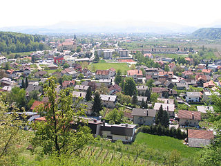
Vojnik is the largest settlement and the centre of the Municipality of Vojnik in eastern Slovenia. It lies on the Hudinja River, north of Celje. Traditionally the area was part of the Lower Styria region. The municipality is now included in the Savinja Statistical Region.

Medlog Place in Styria, Slovenia

Medlog is a settlement in the City Municipality of Celje in eastern Slovenia. It lies on the western outskirts of Celje. The grass runway of Celje Airport is located in the western part of the settlement. The area was traditionally part of the Styria region. It is now included with the rest of the municipality in the Savinja Statistical Region.

Trnovo, Nova Gorica Place in Slovenian Littoral, Slovenia

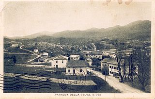
Trnovo is a village in western Slovenia in the Municipality of Nova Gorica. It is located on the high Trnovo Forest Plateau in the traditional Slovene Littoral region.

Voglarji Place in Slovenian Littoral, Slovenia

Voglarji is a dispersed settlement in the Municipality of Nova Gorica in western Slovenia. It is located on the high Trnovo Forest Plateau, overlooking the Vipava Valley. Voglarji includes the hamlets of Zavrh and Cvetrež.

Pameče Place in Styria, Slovenia

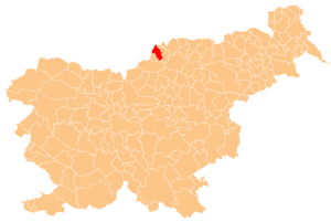
Pameče is a settlement in the City Municipality of Slovenj Gradec in northern Slovenia. The area was traditionally part of Styria. The entire municipality is now included in the Carinthia Statistical Region.

Podgorje, Kamnik Place in Upper Carniola, Slovenia

Podgorje is a settlement that is a now a suburb of the town of Kamnik in the Upper Carniola region of Slovenia.

Dolenje pri Jelšanah Place in Inner Carniola, Slovenia

Dolenje pri Jelšanah is a village north of Jelšane in the Municipality of Ilirska Bistrica in the Inner Carniola region of Slovenia, next to the border with Croatia. The settlement includes the hamlets of Dolnji Kraj, Gornji Kraj, and Vrh Žloštajna.

Dolnji Zemon Place in Inner Carniola, Slovenia

Dolnji Zemon is a small settlement on the left bank of the Reka River south of Ilirska Bistrica in the Inner Carniola region of Slovenia. It includes the hamlet of Zemonska Vaga.

Harije Place in Inner Carniola, Slovenia

Harije is a village in the hills west of Ilirska Bistrica in the Inner Carniola region of Slovenia.

Jelšane Place in Inner Carniola, Slovenia

Jelšane is a village in the Municipality of Ilirska Bistrica in the Inner Carniola region of Slovenia, right on the border with Croatia. The Jelšane international border crossing between Slovenia and Croatia is just south of the village.

Novokračine Place in Inner Carniola, Slovenia

Novokračine is a village east of Jelšane in the Municipality of Ilirska Bistrica in the Inner Carniola region of Slovenia on the border with Croatia.

Kozarišče Place in Inner Carniola, Slovenia

Kozarišče is a village south of Stari Trg pri Ložu in the Municipality of Loška Dolina in the Inner Carniola region of Slovenia. The area of the village extends south of the main settlement right to the Snežnik Plateau and to the border with Croatia. Snežnik Castle, a 13th-century castle, is located just southwest of the village.

Selovec Place in Carinthia, Slovenia

Selovec is a dispersed settlement in the hills south of Dravograd in the Carinthia region in northern Slovenia.

Veliki Kamen Place in Styria, Slovenia

Veliki Kamen is a settlement northeast of Senovo in the Municipality of Krško in eastern Slovenia. The area was traditionally part of Styria. It is now included with the rest of the municipality in the Lower Sava Statistical Region.

Sajevce, Kostanjevica na Krki Place in Lower Carniola, Slovenia

Sajevce is a small settlement on the left bank of the Krka River in the Municipality of Kostanjevica na Krki in eastern Slovenia. The area was traditionally part of Lower Carniola and is now included in the Lower Sava Statistical Region.

Ravenska Vas Place in Upper Carniola, Slovenia

Ravenska Vas is a settlement immediately east and southeast of Zagorje ob Savi in central Slovenia. The area is part of the traditional region of Upper Carniola. It is now included with the rest of the municipality in the Central Sava Statistical Region.

Polajna Place in Styria, Slovenia

Polajna is a small settlement in the Municipality of Zreče in northeastern Slovenia. It lies on the main road from Zreče to Vitanje. The area was traditionally part of Styria and is now included with the rest of the municipality in the Savinja Statistical Region.

Novo Tepanje Place in Styria, Slovenia

Novo Tepanje is a settlement in the Municipality of Slovenske Konjice in eastern Slovenia. It lies on the regional road from Slovenske Konjice to Slovenska Bistrica on the left bank of Oplotnica Creek, a left tributary of the Dravinja River. The area is part of the traditional region of Styria. The municipality is now included in the Savinja Statistical Region.

Pečje Place in Styria, Slovenia

Pečje is a settlement in the Municipality of Sevnica in central Slovenia. It lies just east of Sevnica above the left bank of the Sava River The area is part of the historical region of Styria. The municipality is now included in the Lower Sava Statistical Region.

References