
The Drava or Drave, historically known as the Dravis or Dravus, is a river in southern Central Europe. With a length of 710km, or 724km, if the length of its Sextner Bach source is added, it is the fifth or sixth longest tributary of the Danube, after the Tisza, Sava, Prut, Mureș and likely Siret. The Drava drains an area of about 40,154 square kilometers. Its mean annual discharge is seasonally 500m³/s to 670m³/s. Its source is near the market town of Innichen, in the Puster Valley of South Tyrol, Italy. The river flows eastwards through East Tyrol and Carinthia in Austria into the Styria region of Slovenia. It then turns southeast, passing through northern Croatia and, after merging with its main tributary the Mur, forms most of the border between Croatia and Hungary, before it joins the Danube near Osijek, in Croatia.

Carinthia, also Slovene Carinthia or Slovenian Carinthia, is a traditional region in northern Slovenia. The term refers to the small southeasternmost area of the former Duchy of Carinthia, which after World War I was allocated to the State of Slovenes, Croats and Serbs according to the 1919 Treaty of Saint-Germain. It has no distinct centre, but a local centre in each of the three central river valleys among the heavily forested mountains.

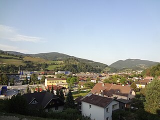
Dravograd is a small town in northern Slovenia, close to the border with Austria. It is the seat of the Municipality of Dravograd. It lies on the Drava River at the confluence with the Meža and the Mislinja. It is part of the traditional Slovenian provinces of Carinthia and the larger Carinthia Statistical Region.

Črneče is a village on the right bank of the Drava River in the Municipality of Dravograd in the Carinthia region in northern Slovenia.

The Mislinja is a river in the northern part of Slovenia. It is 36 km (22 mi) long. It flows through Mislinja and Slovenj Gradec and empties from the right into the Meža River north of the village of Otiški Vrh near Dravograd, only a couple hundred meters before the Meža joins the Drava River.

Črna na Koroškem is a town in northern Slovenia. It is the seat of the Municipality of Črna na Koroškem. It lies in the traditional Slovenian province of Carinthia, close to the border with Austria. Since 2005 it has been part of the larger Carinthia Statistical Region.

Gail is the name of a river in southern Austria, the largest right tributary of the Drava. Its drainage basin is 1,413.9 km2 (545.9 sq mi).

Ravne Castle is a castle near the town of Ravne na Koroškem, in the Carinthia region of northern Slovenia.

The Eastern Alps are usually defined as the area east of a line from Lake Constance and the Alpine Rhine valley, up to the Splügen Pass at the Alpine divide, and down the Liro River to Lake Como in the south. The peaks and mountain passes are lower than the Western Alps, while the range itself is broader and less arched.

The Carinthia Statistical Region is a statistical region in northern Slovenia along the border with Austria.
Dobja Vas is a former settlement on the right bank of the Meža River and a neighborhood in urban area of Ravne na Koroškem in the Carinthia region in northern Slovenia. In 2017 it was merged into Ravne na Koroškem.
Dobrije is a small settlement on the right and left banks of the Meža River in the Municipality of Ravne na Koroškem in the Carinthia region in northern Slovenia.
Bistra is a dispersed settlement in the valley of Bistra Creek, a tributary of the Meža River, and the surrounding hills southwest of Črna na Koroškem in the Carinthia region in northern Slovenia.
Koprivna is a dispersed settlement in the Upper Meža Valley in the hills west of Črna na Koroškem in the Carinthia region of northern Slovenia on the border with Austria.

Franjo Malgaj was a Slovenian soldier, military leader and poet. He was an officer of the Austro-Hungarian Army. After the dissolution of the Austro-Hungarian Empire after World War I, he became one of the commanding officers in the Slovene volunteer army under Rudolf Maister's command that fought against German Austrian units during the struggle for the northern Slovenian borderlands. He later became an officer in the Army of Kingdom of Serbs, Croats and Slovenes. He died during the Austrian-Yugoslav struggles in 1919. He is considered a Slovenian national hero.
The Mežica dialect is a Slovene dialect in the Carinthian dialect group. It is spoken in the triangle bounded by Črna na Koroškem, Dravograd, and Mislinja. Major settlements in the dialect area are Slovenj Gradec, Ravne na Koroškem, Prevalje, and Mežica.
The Municipality of Črna na Koroškem is a municipality in northern Slovenia. The seat of the municipality is the town of Črna na Koroškem. It lies in the traditional Slovenian province of Carinthia, close to the border with Austria. Since 2005 it has been part of the larger Carinthia Statistical Region. It borders Austria.
The Municipality of Dravograd is a municipality in northern Slovenia, on the border with Austria. The seat of the municipality is the town of Dravograd. The Drava River runs through the middle of the municipality. Most of its territory is part of the traditional Slovenian province of Carinthia, but a large southern and eastern part of its territory is part of the traditional Slovenian province of Styria. It is also part of the larger Carinthia Statistical Region.
The Austro-Slovene conflict in Carinthia was a military engagement that ensued in the aftermath of World War I between forces loyal to the State of Slovenes, Croats and Serbs and later the Kingdom of Serbs, Croats and Slovenes, and forces loyal to the Republic of German-Austria. The main theater of the conflict was the linguistically mixed region in southeastern Carinthia. The conflict was settled by the Treaty of Saint-Germain in 1919, which stipulated that the territorial dispute be resolved by a plebiscite.

The Geopark Karawanken/Karavanke is located in the Karawanks mountain range in Austria and in Slovenia and comprises an area of 1067 km2. The crossborder geopark has numerous geological and other natural sights and became a member of the UNESCO Global Geoparks Network in 2013.


