Lake Bohinj

Last updated
Lake Bohinj
Wocheiner See.jpg
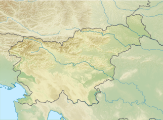
Slovenia relief map.png
Red pog.svg
Lake Bohinj
Location Municipality of Bohinj, Triglav National Park
Coordinates 46°16′56.31″N13°51′29.6″E / 46.2823083°N 13.858222°E / 46.2823083; 13.858222 Coordinates: 46°16′56.31″N13°51′29.6″E / 46.2823083°N 13.858222°E / 46.2823083; 13.858222
Type Glacial lake
Primary inflows Savica
Primary outflows Sava Bohinjka
Catchment area 107 km2 (41 sq mi)
Basin  countriesSlovenia
Max. length4.35 km (2.70 mi)
Max. width1 km (0.62 mi)
Surface area3.18 km2 (1.23 sq mi)
Average depth30 m (98 ft)
Max. depth45 m (148 ft)
Water volume99.7×10^6 m3 (80,800 acre⋅ft)
Residence time 0.3 to 0.5 years [1]
Surface elevation526 m (1,726 ft)
References [1]

Lake Bohinj (Slovene : Bohinjsko jezero, German : Wocheiner See), covering 318 hectares (790 acres), is the largest permanent lake in Slovenia. [2] [notes 1] It is located within the Bohinj Valley of the Julian Alps, in the northwestern Upper Carniola region, and part of Triglav National Park.
Contents

Geography

Lake Bohinj Bohinjsko jezero s peci.jpg
Lake Bohinj

Lake Bohinj is 4.2 km (2.6 mi) long and 1 km (0.62 mi) at its maximum width. [3] It is a glacial lake dammed by a moraine. The largest of the streams that flow into the lake, the Savica ('little Sava'), [4] is fed from Črno jezero (Black Lake), the lowest-lying lake in the Triglav Lakes Valley. The outflow at the eastern end is the Jezernica creek which merges with the Mostnica to form the Sava Bohinjka, which in turn becomes the larger Sava River at the confluence with the Sava Dolinka. As found out already by Belsazar Hacquet in the 18th century, much more water leaves Lake Bohinj than enters it, which is explained with subterranean sources of water.

The clear waters are the habitat of brown trout, burbot, European chub, common minnow and Arctic char, eight genera of molluscs, as well as of numerous algae species. It is a popular day trippers' destination for swimming and other water sports. On the shore is a statue of the legendary Goldhorn (Zlatorog) chamois, whose story was perpetuated by the poet Rudolf Baumbach.

Notes

  1. Lake Cerknica, an intermittent lake, is larger than Lake Bohinj during its flood seasons, but disappears entirely during dry seasons.

Related Research Articles

Geography of Albania

Albania is a small country in Southern, Southeastern Europe and Western Balkans strategically positioned on the Adriatic and Ionian Sea inside the Mediterranean Sea, with a coastline of about 476 km (296 mi). It is bounded by Montenegro to the northwest, Kosovo to the northeast, North Macedonia to the east and Greece to the southeast and south.

Geography of Slovenia

Slovenia is situated at the crossroads of central and southeast Europe, touching the Alps and bordering the Adriatic Sea. The Alps—including the Julian Alps, the Kamnik-Savinja Alps and the Karawank chain, as well as the Pohorje massif—dominate northern Slovenia along its long border to Austria. Slovenia's Adriatic coastline stretches approximately 47 km (29 mi) from Italy to Croatia. Its part south of Sava river belongs to Balkan peninsula – Balkans.

Carniola Historical region in Slovenia

Carniola is a historical region that comprised parts of present-day Slovenia. Although as a whole it does not exist anymore, Slovenes living within the former borders of the region still tend to identify with its traditional parts Upper Carniola, Lower Carniola, and to a lesser degree with Inner Carniola. In 1991, 47% of the population of Slovenia lived within the borders of the former Duchy of Carniola.

Triglav National Park

Triglav National Park (TNP) is the only national park in Slovenia. It was established in its modern form in 1981 and is located in the northwestern part of the country, respectively the southeastern part of the Alpine massif. Mount Triglav, the highest peak of the Julian Alps, stands almost in the middle of the national park. From it the valleys spread out radially, supplying water to two large river systems with their sources in the Julian Alps: the Soča and the Sava, flowing to the Adriatic and Black Sea, respectively.

Bled Place in Upper Carniola, Slovenia

Bled is a town on Lake Bled in the Upper Carniolan region of northwestern Slovenia. It is the administrative seat of the Municipality of Bled. It is most notable as a popular tourist destination in the Upper Carniola region and in Slovenia as whole, attracting visitors from abroad too.

Julian Alps

The Julian Alps are a mountain range of the Southern Limestone Alps that stretch from northeastern Italy to Slovenia, where they rise to 2,864 m at Mount Triglav, the highest peak in Slovenia and of the former Yugoslavia. A large part of the Julian Alps is included in Triglav National Park. The second highest peak of the range, the 2,755 m high Jôf di Montasio, lies in Italy.

Tourism in Slovenia

Slovenia offers tourists a wide variety of landscapes: Alpine in the northwest, Mediterranean in the southwest, Pannonian in the northeast, and Dinaric in the southeast. They roughly correspond to the traditional regions of Slovenia, based on the former four Habsburg crown lands. Each offers its own natural, geographic, architectural, and cultural features. Slovenia has mountains, meadows, lakes, caves, and the sea, making it an attractive destination in Europe.

Sava River in Central Europe

The Sava is a river in Central and Southeast Europe, a right tributary of the Danube. It flows through Slovenia, Croatia and along its border with Bosnia and Herzegovina, and finally through Serbia, feeding into the Danube in its capital, Belgrade. The Sava forms the main northern limit of the Balkan Peninsula, and the southern edge of the Pannonian Plain.

Triglav Lakes Valley Valley in the Julian Alps, Slovenia

The Triglav Lakes Valley is a rocky hanging valley in the Julian Alps in Slovenia, below the sheer sides of Mount Tičarica and Mount Zelnarica southwest of Triglav. The valley is also called the Seven Lakes Valley, although there are ten and not seven lakes in the valley. It is above the tree line and is geologically alpine karst; therefore it has also been termed the Sea of Stone Valley.

Lake Cerknica

Lake Cerknica is an intermittent lake in the southern part of the Cerknica Polje, a karst polje in Inner Carniola, a region in southwestern Slovenia. The lake, oriented in the Dinaric direction from northwest to southeast, is present for the most part of the year. When full, it is the largest lake in the country. The plain is surrounded by the Javornik Hills to the south and Slivnica to the north, both belonging to Dinaric Alps. The area of the lake mainly reaches 28 square kilometres (11 sq mi), but can reach up to 38 km2 (15 sq mi) and the surface level varies from 546 m (1,791 ft) to 551 m (1,808 ft) above sea level. The lake is an important wildlife resort, especially as a nesting place for many bird species. Botanically, it is distinguished by amphibious plants. It is therefore a part of two Natura 2000 areas of protection and the focus of the Inner Carniola Regional Park, which covers additional Natura 2000 areas in the broader region. The climate in the area is continental, with a mean temperature of 9.2 °C (48.6 °F) and the annual precipitation about 1,700 millimetres (67 in). The largest settlement at the border of the lake is Cerknica, located north of the lake. Various watersports, including rowing, are popular on the lake.

Bohinj

Bohinj, or the Bohinj Valley or Bohinj Basin, is a 20 km long and 5 km wide basin in the Julian Alps, in the Upper Carniola region of northwestern Slovenia. It is traversed by the Sava Bohinjka river. Its main feature is the periglacial Lake Bohinj. Bohinj is part of the Municipality of Bohinj, the seat of which is Bohinjska Bistrica.

Sava Dolinka

The Sava Dolinka is a headwater of the Sava River in northwestern Slovenia. The 45 kilometres (28 mi) long Sava Dolinka starts as Nadiža Creek in the Planica Valley under Mount Zadnja Ponca in the Julian Alps, at an elevation of 1222 m, close to the Italian border. The stream goes underground soon after its source and breaks out again after 5 km at an elevation of 842 m in Zelenci, near Kranjska Gora. The Sava Dolinka flows through Kranjska Gora, Gozd Martuljek, Jesenice, between Bled and Breg, and past the town of Lesce. The first in a series of hydroelectric power plants on the river, the Moste Hydro Power Plant, is located near Žirovnica. It merges with the second major headwater of the Sava, the Sava Bohinjka, at Radovljica. Tributaries of the Sava Dolinka include the Triglav Bistrica at Mojstrana and the Radovna, which flows through the Vintgar Gorge near Bled.

Bohinj Railway

The Bohinj Railway is a railway in Slovenia and Italy. It connects Jesenice in Slovenia with Trieste in Italy. It was built by Austria-Hungary from 1900 to 1906 as a part of a new strategic railway, the Neue Alpenbahnen, that would connect Western Austria and Southern Germany with the then Austro-Hungarian port of Trieste. The line starts in Jesenice, at the Southern end of the Karawanks Tunnel; it then crosses the Julian Alps through the Bohinj Tunnel, and passes the border town of Nova Gorica before crossing the Italian border and reaching Trieste.

Sava Bohinjka

The Sava Bohinjka is a headwater of the Sava River in northwestern Slovenia. At 41 kilometres (25 mi) in length, it is the shorter of the two headwaters that become the Sava River in Radovljica, the other being the 45 km (28 mi)-long Sava Dolinka.

Bohinjska Bistrica Place in Upper Carniola, Slovenia

Bohinjska Bistrica is the largest settlement and administrative centre of the Municipality of Bohinj, in the Upper Carniola region of northwestern Slovenia.

Vogel Ski Resort

Vogel Ski Resort is a Slovenian ski resort located above Bohinj next to Lake Bohinj. The nearest city is Bled. Ljubljana is about an hour away. The resort was opened in 1964. It has a total of 22 kilometres (14 mi) of ski slopes, 8 kilometres (5.0 mi) tracks for cross country skiing and a snowboard park. The ski resort is located on the outskirts of Triglav National Park, therefore all snowmaking activities are forbidden on the area.

The Šalek Valley or the Velenje Basin is a basin in northern Slovenia in the northeastern pre-alpine foothills. It is named after Šalek Castle near the town of Velenje. The valley lies between the Kamnik–Savinja Alps to the west, the Pohorje Mountain Range to the east, and the Sava Hills to the south. It has a northwest-southeast orientation and is approximately 8 km long and 2 km wide. It contains a number of rivers and lakes. The Paka River runs through Velenje, with a number of tributaries from the northwest: Trebušnica Creek, Veriželj Creek and Slatina Creek. The Paka itself eventually flows into the Savinja River. The valley is separated from the Upper Savinja Valley and Lower Savinja Valley by the Golte Plateau, the Skorno Hills (Skornški hribi, peaks along the Paka including Mount Oljka, and the Ponikva Plateau.

Black Lake (Triglav Lakes Valley)

Black Lake is the lowest-lying lake in the Triglav Lakes Valley, part of the Julian Alps in Slovenia. It is named for its location in a basin in the middle of the forest, which stretches right to the edge of the Komarča rock face. Because of its relatively low elevation, it is the warmest of the Triglav Lakes. At the surface, its temperature in summer is 9 °C (48 °F), whereas in winter it is 3 °C (37 °F). It is 150 m (490 ft) long, 80 m (260 ft) wide, and up to 6 m (20 ft) deep. The Alpine Newt, endemic to the Alps, lives in it.

Savica (waterfall)

Savica Falls is a waterfall in northwestern Slovenia. It is 78 meters (256 ft) high and is fed by a karst spring also called Savica just above the waterfall.

References

  1. 1 2 Lake Bohinj in "Alpine lakes. Survey between land and water" (PDF). (52.1 MB) , page 43
  2. Hlad, Branka; Skoberne, Peter, eds. (2001). "Characteristics of Biological and Landscape Diversity in Slovenia". Biological and Landscape Diversity in Slovenia: An Overview (PDF). Ljubljana: Environmental Agency of the Republic of Slovenia, Ministry of the Environment and Spatial Planning. p. 13. ISBN   961-6324-17-9. Archived from the original (PDF) on 2012-11-25.
  3. Royal Geographical Society (1856) "Wocheiner-See" A Gazetteer of the World: or, Dictionary of geographical knowledge, compiled from the most recent authorities, and forming a complete body of modern geography -- physical, political, statistical, historical, and ethnographical A. Fullarton, Edinburgh, Scotland, p. 529, OCLC 20348227; note that Lake Bohinj was formerly known in English by its German name Wocheiner See, or sometimes Lake Wochein.
  4. Baedeker, Karl (1879) "Terglou: The Valley of the Wocheiner Save" The Eastern Alps: Including the Bavarian Highlands, the Tyrol, Salzkammergut, Styria, and Carinthia (4th ed.) Dulau and Co., London, p. 353, OCLC   4018143