This article needs additional citations for verification .(May 2012) (Learn how and when to remove this template message) |
| Lahinja | |
|---|---|
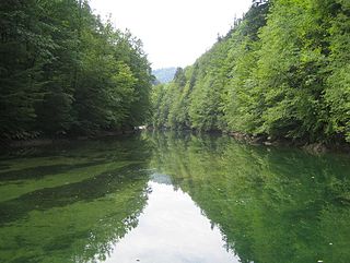
Lahinja, 2006 | |
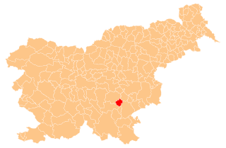
| Country | Slovenia |
| Physical characteristics | |
| Main source | 150 m (490 ft) [1] |
| River mouth | Kupa (Kolpa) 130 m (430 ft) [1] 45°37′43″N15°18′04″E / 45.6287°N 15.3010°E Coordinates: 45°37′43″N15°18′04″E / 45.6287°N 15.3010°E |
| Length | 34 km (21 mi) [1] |
| Basin features | |
| Progression | Kupa→ Sava→ Danube→ Black Sea |
| Basin size | 360 km2 (140 sq mi) [1] |

The Lahinja is a river in White Carniola, the extreme southeastern part of Slovenia. It is 34 kilometres (21 mi) long [1] and originates from several karst springs at the end of a steephead valley between the villages of Knežina, Belčji Vrh, and Mali Nerajec.

A river is a natural flowing watercourse, usually freshwater, flowing towards an ocean, sea, lake or another river. In some cases a river flows into the ground and becomes dry at the end of its course without reaching another body of water. Small rivers can be referred to using names such as stream, creek, brook, rivulet, and rill. There are no official definitions for the generic term river as applied to geographic features, although in some countries or communities a stream is defined by its size. Many names for small rivers are specific to geographic location; examples are "run" in some parts of the United States, "burn" in Scotland and northeast England, and "beck" in northern England. Sometimes a river is defined as being larger than a creek, but not always: the language is vague.

White Carniola is a traditional region in southeastern Slovenia on the border with Croatia. Due to its smallness, it is often considered a subunit of the broader Lower Carniola region, although with distinctive cultural, linguistic, and historical features.

Slovenia, officially the Republic of Slovenia, is a sovereign state located in southern Central Europe at a crossroads of important European cultural and trade routes. It is bordered by Italy to the west, Austria to the north, Hungary to the northeast, Croatia to the southeast, and the Adriatic Sea to the southwest. It covers 20,273 square kilometers (7,827 sq mi) and has a population of 2.07 million. One of the successor states of the former Yugoslavia, Slovenia is a parliamentary republic and a member of the United Nations, of the European Union, and of NATO. The capital and largest city is Ljubljana.
In its upper course the river flows towards the north in a narrow bed with a very shallow gradient, resulting in the fact that it meanders significantly. All of its major affluents join it from the west and all of them start from karst springs. At Dragatuš it is joined by its major tributary Podturnščica Creek, and at Črnomelj by Dobličica Creek. From the outflow of Podturnščica Creek the bed of the Lahinja is narrow and up to 20 m deep, with numerous bends. At the vicinity of one of them stands Gradac Castle. From Črnomelj to Gradac the river has no surface affluents, but below Gradac it is joined by the high-volume and faster-flowing Krupa. After its confluence with the Krupa, the Lahinja turns towards the east. It joins the Kolpa at Primostek.

Dragatuš is a village south of Črnomelj in the White Carniola area of southeastern Slovenia. The area is part of the traditional region of Lower Carniola and is now included in the Southeast Slovenia Statistical Region.

Črnomelj is a town in southeastern Slovenia. It is the seat of the Municipality of Črnomelj. It lies on the left bank of the Lahinja and Dobličica rivers. The municipality is at the heart of the area of White Carniola, the southeastern part of the traditional region of Lower Carniola. It is now included in the Southeast Slovenia Statistical Region. It includes the hamlets of Čardak, Kočevje, Kozji Plac, Loka, and Nova Loka.

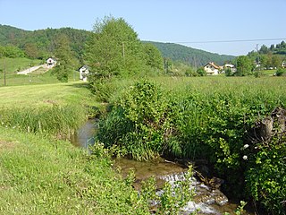
The Dobličica is a stream in White Carniola. It is part of a karst aquifer. Due to its geological and hydrological characteristics and urbanization of the area, it is considered sensitive and subject to pollution.
The Lahinja's river basin is asymmetric because it receives the majority of its surface affluents from the right side. It is a part of the Sava Basin. The Lahinja Regional Park extends from Knežina to Pusti Gradec, along the first seven km (4.5 mi) of the Lahinja.

The Sava is a river in Central and Southeastern Europe, a right tributary of the Danube. It flows through Slovenia, Croatia, along the northern border of Bosnia and Herzegovina, and through Serbia, discharging into the Danube in Belgrade. Its central part is a natural border of Bosnia-Herzegovina and Croatia. The Sava forms the northern border of the Balkan Peninsula, and the southern edge of the Pannonian Plain.

Pusti Gradec is a small settlement east of Dragatuš in the Municipality of Črnomelj in the White Carniola area of southeastern Slovenia. The area is part of the traditional region of Lower Carniola and is now included in the Southeast Slovenia Statistical Region.