
Kočevje is a city in the Municipality of Kočevje in southern Slovenia. It is the seat of the municipality.
The Nevljica is a river in the Municipality of Kamnik, Slovenia. It comes out below Kozjak Hill and flows through the Tuhinj Valley. It also flows through the settlements of Nevlje and Mekinje. It is a left tributary of the Kamnik Bistrica.

Podravina or Podravje are Slavic names for the Drava river basin in Croatia and Slovenia.
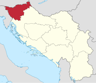
The Drava Banovina or Drava Banate, was a province (banovina) of the Kingdom of Yugoslavia between 1929 and 1941. This province consisted of most of present-day Slovenia and was named for the Drava River. The capital city of the Drava Banovina was Ljubljana.

The Sava Banovina or Sava Banate, was a province (banovina) of the Kingdom of Yugoslavia between 1929 and 1939. It was named for the Sava River and consisted of much of the present-day Croatia. Until 1931, it also comprised White Carniola, now part of Slovenia. The capital city of the Sava Banovina was Zagreb.

Lower Carniola is a traditional region in Slovenia, the southeastern part of the historical Carniola region.
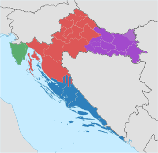
The Republic of Croatia is administratively organised into twenty counties, and is also traditionally divided into four historical and cultural regions: Croatia proper, Dalmatia, Slavonia, and Istria. These are further divided into other, smaller regions.

Gottschee refers to a former German-speaking region in Carniola, a crownland of the Habsburg Empire, part of the historical and traditional region of Lower Carniola, now in Slovenia. The region has been a county, duchy, district, and municipality during various parts of its history. The term often also refers to the entire ethnolinguistic enclave regardless of administrative borders. Today Gottschee largely corresponds to the Municipality of Kočevje. The original German settlers of the region are called Gottschee Germans or Gottscheers, and their German dialect is called Gottschee German or Gottscheerish.

The Old Bridge, also named the State Bridge, the Main Bridge and the Drava Bridge, is a bridge crossing the Drava River in Maribor, northeastern Slovenia. It links Carinthia Street and Pobrežje Street and is 270 metres (890 ft) long. Its central part, spanning across the Drava, is 166 m (545 ft) long and has three steel arches.
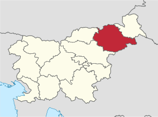
The Drava Statistical Region is a statistical region in Slovenia. The largest town in the region is Maribor. Its name comes from the Drava River and includes land on both banks along its course through Slovenia as well as the Pohorje mountains in the northeast of the region. The Drava is used for the production of hydroelectricity and the fertile land around it is used for agriculture. The share of job vacancies in all available jobs is among the highest in Slovenia and the region has a positive net migration rate but a very high natural decrease, which means an overall decrease in the population.
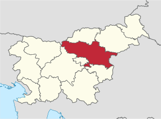
The Savinja Statistical Region is a statistical region in Slovenia. The largest town in the region is Celje. It is named after the Savinja River. The region is very diverse in natural geography; it mainly comprises the wooded mountainous terrain attractive to tourists, the fertile Lower Savinja Valley with good conditions for growing hops, the Kozje Hills, and the Velenje Basin with lignite deposits, used for electricity production. In 2013 the region invested more than EUR 127 million in environmental protection. In 2013, the region accounted for 14% of enterprises created and 8% of enterprises shut down. The region has good natural conditions for agriculture. In 2013 this region had more than 11,000 farms, which is 15% of all farms in Slovenia, ranking the region right behind the Drava Statistical Region. In agricultural area utilised and livestock, the region was also in second place. The region is a well-known and popular tourist destination. In 2012, tourist arrivals and overnight stays in the region represented 11.1% of all tourist arrivals in Slovenia and 15.0% of all overnight stays. On average, tourists spent four nights there.

Breg pri Kočevju is a settlement on the left bank of the Rinža River north of Kočevje in southern Slovenia. The area is part of the traditional region of Lower Carniola and is now included in the Southeast Slovenia Statistical Region.

Dolnje Ložine is a small settlement in the Upper Rinža Valley northwest of Kočevje in southern Slovenia. The area is part of the traditional region of Lower Carniola and is now included in the Southeast Slovenia Statistical Region.

Livold is a village in the Kočevje Polje southeast of the town of Kočevje in southern Slovenia. The area is part of the traditional region of Lower Carniola and is now included in the Southeast Slovenia Statistical Region. The village stretches along the road connecting Kočevje and Petrina, near the turn to Mozelj. It has a pronounced outline. The Rinža River flows through the village; it often goes dry in the summer but floods during heavy rains. There are many karst caves in the area. The Stojna Ridge and Dry Hill rise to the west, and the karstified Šahen lowland lies to the east.
Mrtvice is a settlement northwest of the town of Kočevje in southern Slovenia. The area is part of the traditional region of Lower Carniola and is now included in the Southeast Slovenia Statistical Region.
Slovenska Vas is a settlement on the Rinža River west of Stara Cerkev in the Municipality of Kočevje in southern Slovenia. The area is part of the traditional region of Lower Carniola and is now included in the Southeast Slovenia Statistical Region.

Tihaboj is a nucleated settlement in the local community of Gabrovka, Municipality of Litija, central Slovenia. It lies on a terrace in the Gabrovka Hills, a part of the Mirna Valley, along the road connecting Litija and Mirna. The landscape has a fluviokarst character. The settlement comprises the hamlets of Mlake, Orešje, and Psina. The residents mainly live from farming and service activities; many of them drive to work to nearby places.

Jelenja Vas is a hamlet of the village of Štalcerji in the Municipality of Kočevje in southern Slovenia. Formerly, it was an independent settlement. The area is part of the traditional region of Lower Carniola and is now included in the Southeast Slovenia Statistical Region.
Podjetniško Naselje Kočevje is a settlement above the left bank of the Rinža River, immediately northwest of the town of Kočevje in southern Slovenia. The area is part of the traditional region of Lower Carniola and is now included in the Southeast Slovenia Statistical Region.

Union Brewery is one of the largest breweries in Slovenia. It was formed in 1864 in Ljubljana and became part of Heineken International in 2015. Since 1987 it includes also a Museum of beer.


