
Provo Municipal Airport is a public-use airport two miles [3.2 km] west of Provo, in Utah County, Utah. It is a small regional airport with domestic flights mainly to destinations in the western United States.

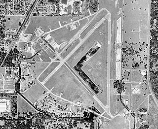
Oakland County International Airport is a county-owned public-use airport located in Waterford Township, Oakland County, Michigan, United States. The airport is located approximately one mile from the center of Waterford Township and Oakland County. It is included in the Federal Aviation Administration (FAA) National Plan of Integrated Airport Systems for 2017–2021, in which it is categorized as a non primary commercial service facility.

Ann Arbor Municipal Airport is a general aviation airport in Washtenaw County, Michigan, United States. It is included in the Federal Aviation Administration (FAA) National Plan of Integrated Airport Systems for 2017 to 2021, in which it is categorized as a regional general aviation facility.
Cranland Airport, in Hanson, Massachusetts is a public use airport owned by Cranland Inc. It has one runway, averages 102 flights per week, and has approximately 28 aircraft based on its field.
Zephyrhills Municipal Airport is a public use airport in Pasco County, Florida, United States. It is owned by the City of Zephyrhills and located one nautical mile (2 km) southeast of its central business district. This airport is included in the National Plan of Integrated Airport Systems for 2011–2015, which categorized it as a general aviation facility.
Grosse Ile Municipal Airport is two miles south of Grosse Ile, in Wayne County, Michigan. It is owned by the Township of Grosse Ile. The Federal Aviation Administration (FAA) National Plan of Integrated Airport Systems for 2017–2021 categorized it as a local reliever airport facility.
Gladwin Zettel Memorial Airport is a public use airport located one nautical mile (2 km) southeast of the central business district of Gladwin, a city in Gladwin County, Michigan, United States. The airport is owned by the city and county. It is included in the Federal Aviation Administration (FAA) National Plan of Integrated Airport Systems for 2017–2021, in which it is categorized as a local general aviation facility.
Atlanta Municipal Airport is a public airport located one mile (2 km) southeast of the central business district of Atlanta in Montmorency County, Michigan, United States. The airport is owned by Briley Township and Avery Township. It is located at coordinates 44°59′47″N84°07′37″W is accessible by road from Airport Road, located near M-32, and M-33. It is included in the Federal Aviation Administration (FAA) National Plan of Integrated Airport Systems for 2017–2021, in which it is categorized as a basic general aviation facility.

Hillsdale Municipal Airport is a public use airport located three nautical miles (6 km) east of the central business district of Hillsdale, in Hillsdale County, Michigan, United States. It is included in the Federal Aviation Administration (FAA) National Plan of Integrated Airport Systems for 2017–2021, in which it is categorized as a local general aviation facility.
New Ulm Municipal Airport is a public airport located two statute miles (3 km) west of the central business district (CBD) of New Ulm, a city in Brown County, Minnesota, United States. This general aviation airport covers 195 acres (79 ha) and has two runways. Operational since September 1945, scheduled airline service was once available on Midwest Aviation, also known as Lake State Airways, though today only charter flights are offered by the city's New Ulm Flight Service, founded in the 1960s.
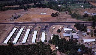
Stark's Twin Oaks Airpark is a privately owned public-use airport located 4 miles (6.4 km) south of the city of Hillsboro in Washington County, Oregon, United States.
Welke Airport is a privately-owned, public use airport located on Beaver Island in Charlevoix County, Michigan, United States. Scheduled passenger service to Charlevoix Municipal Airport in Charlevoix, Michigan, is provided by Island Airways.

James Clements Municipal Airport is a city-owned, public-use airport located three nautical miles (6 km) south of the central business district of Bay City, in Bay County, Michigan, United States. It is included in the Federal Aviation Administration (FAA) National Plan of Integrated Airport Systems for 2017–2021, in which it is categorized as a local general aviation facility. It is also a seaplane base with landing areas on the Saginaw River, adjacent to the airport.
Arcadia Municipal Airport is a public-use airport located 1 mile (1.6 km) southeast of the central business district of the city of Arcadia in DeSoto County, Florida, United States. The airport is publicly owned.
Dowagiac Municipal Airport is a public airport owned and operated by the City of Dowagiac located 1m (1.6 km) northwest of Dowagiac, Michigan, United States. The uncontrolled airport is used for general aviation purposes. It is included in the Federal Aviation Administration (FAA) National Plan of Integrated Airport Systems for 2017–2021, in which it is categorized as a local general aviation facility.
Grand Haven Memorial Airpark is a public airport owned and operated by the City of Grand Haven located 2 miles (3.2 km) southeast of Grand Haven, Michigan. The airport is uncontrolled, and is used for general aviation purposes. It is included in the Federal Aviation Administration (FAA) National Plan of Integrated Airport Systems for 2017–2021, in which it is categorized as a local general aviation facility.
Anderson Municipal Airport is a public use airport three miles east of Anderson in Madison County, Indiana. The National Plan of Integrated Airport Systems for 2011–2015 categorized it as a general aviation facility. The airport currently has no scheduled air service.
Hastings Airport is a public use airport located three nautical miles (6 km) west of the central business district of Hastings, a city in Barry County, Michigan, United States. It is owned by the city and county and is also known as Hastings City/Barry County Airport.
Greenville Municipal Airport is a city-owned, public-use airport located three nautical miles (6 km) south of the central business district of Greenville, a city in Montcalm County, Michigan, United States. It is included in the Federal Aviation Administration (FAA) National Plan of Integrated Airport Systems for 2017–2021, in which it is categorized as a local general aviation facility.
The Campbell-Pratt Airport is a publicly owned, public use airport located 1 mile east of Indian River, in Tuscarora Township, Michigan.

