This article needs additional citations for verification .(August 2016) |
Lennep, Montana | |
---|---|
Coordinates: 46°24′58″N110°32′35″W / 46.41611°N 110.54306°W | |
Country | United States |
State | Montana |
County | Meagher |
Elevation | 5,248 ft (1,600 m) |
Time zone | UTC-7 (Mountain (MST)) |
• Summer (DST) | UTC-6 (MDT) |
ZIP code | 59053 |
Area code | 406 |
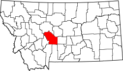
Lennep is a ghost town and populated place in Meagher County, Montana, United States.
Lennep has a still-active Lutheran church, and 3 inhabited houses (as of 2023). Closed buildings include a two-story general store/post office, and a K-8 school. Lennep is located at the foot of the Castle Mountains, and has a south view of the north end of the Crazy Mountains. Lennep is in the valley that divides the two ranges, that contains the South Fork of the Musselshell River. Lennep was once a station on the Old Milwaukee Road. A trackside signal can still be seen along Jawbone Road, where train tracks were removed over 30 years ago. The Lennep Mercantile housed the post office from the time the Mercantile opened in 1914; the post office had first opened in 1903 in a log home across the street. The post office was closed down in 1962.
Today Lennep is a sparsely occupied tourist attraction, with a number of buildings remaining and in reasonable condition, including the church, school, and store. Lennep is surrounded by beef cattle pastures/hay fields, and is frequently visited by deer, moose, cougars, skunks, porcupines, raccoons, beavers, rabbits, hares, and hawks. There are still rural residences in the surrounding vicinity of Lennep, including substantial working ranches.
Climate data for Lennep 5 SW, Montana, 1991–2020 normals, 1959-2020 extremes: 5600ft (1707m) | |||||||||||||
---|---|---|---|---|---|---|---|---|---|---|---|---|---|
Month | Jan | Feb | Mar | Apr | May | Jun | Jul | Aug | Sep | Oct | Nov | Dec | Year |
Record high °F (°C) | 59 (15) | 59 (15) | 70 (21) | 79 (26) | 83 (28) | 90 (32) | 99 (37) | 96 (36) | 95 (35) | 83 (28) | 69 (21) | 62 (17) | 99 (37) |
Mean maximum °F (°C) | 46.6 (8.1) | 48.9 (9.4) | 57.7 (14.3) | 68.8 (20.4) | 75.5 (24.2) | 82.6 (28.1) | 88.5 (31.4) | 88.6 (31.4) | 84.0 (28.9) | 74.0 (23.3) | 58.6 (14.8) | 46.7 (8.2) | 88.6 (31.4) |
Mean daily maximum °F (°C) | 30.9 (−0.6) | 32.0 (0.0) | 40.2 (4.6) | 47.8 (8.8) | 57.5 (14.2) | 66.4 (19.1) | 76.9 (24.9) | 76.6 (24.8) | 66.1 (18.9) | 51.5 (10.8) | 38.1 (3.4) | 30.1 (−1.1) | 51.2 (10.6) |
Daily mean °F (°C) | 21.9 (−5.6) | 21.9 (−5.6) | 29.0 (−1.7) | 35.9 (2.2) | 44.9 (7.2) | 52.5 (11.4) | 60.1 (15.6) | 58.9 (14.9) | 50.3 (10.2) | 39.1 (3.9) | 28.5 (−1.9) | 21.4 (−5.9) | 38.7 (3.7) |
Mean daily minimum °F (°C) | 12.8 (−10.7) | 11.8 (−11.2) | 17.7 (−7.9) | 23.9 (−4.5) | 32.2 (0.1) | 38.6 (3.7) | 43.2 (6.2) | 41.3 (5.2) | 34.5 (1.4) | 26.6 (−3.0) | 19.0 (−7.2) | 12.6 (−10.8) | 26.2 (−3.2) |
Mean minimum °F (°C) | −13.9 (−25.5) | −11.4 (−24.1) | −2.8 (−19.3) | 9.7 (−12.4) | 18.6 (−7.4) | 28.5 (−1.9) | 34.5 (1.4) | 31.0 (−0.6) | 22.4 (−5.3) | 8.5 (−13.1) | −3.5 (−19.7) | −12.6 (−24.8) | −22.8 (−30.4) |
Record low °F (°C) | −38 (−39) | −44 (−42) | −30 (−34) | −10 (−23) | 11 (−12) | 18 (−8) | 28 (−2) | 20 (−7) | 10 (−12) | −15 (−26) | −32 (−36) | −40 (−40) | −44 (−42) |
Average precipitation inches (mm) | 0.99 (25) | 0.86 (22) | 1.07 (27) | 1.86 (47) | 3.06 (78) | 2.92 (74) | 1.49 (38) | 1.32 (34) | 1.33 (34) | 1.58 (40) | 1.05 (27) | 0.98 (25) | 18.51 (471) |
Average snowfall inches (cm) | 17.00 (43.2) | 13.30 (33.8) | 15.50 (39.4) | 12.50 (31.8) | 2.50 (6.4) | 0.30 (0.76) | 0.00 (0.00) | 0.00 (0.00) | 0.90 (2.3) | 7.90 (20.1) | 12.50 (31.8) | 13.20 (33.5) | 95.6 (243.06) |
Source 1: NOAA [1] | |||||||||||||
Source 2: XMACIS2 (records & monthly max/mins) [2] |
The Town of Crestone is a Statutory Town in Saguache County, Colorado. According to the 2020 United States Census, the town's population was 141. Crestone is located at the foot of the western slope of the Sangre de Cristo Range, in the northern part of the San Luis Valley. Crestone was platted in 1880 by George Adams, owner of the neighboring Luis Maria Baca Grant No. 4. In the 1970s, the Baca Grande land development was established on the lands of the Baca Grant to the south and west. Several hundred homes have been built there.
Glacier County is located in the U.S. state of Montana. As of the 2020 census, the population was 13,778. The county is located in northwestern Montana between the Great Plains and the Rocky Mountains, known to the Blackfeet as the "Backbone of the World". The county is geographically and culturally diverse and includes the Blackfeet Indian Reservation, Glacier National Park, and Lewis and Clark National Forest. The county is bordered by 75 miles of international boundary with two ports of entry open year-round and one seasonal international border crossing into Alberta, Canada.
Tenney is an unincorporated community and former city in section 28 of Campbell Township, Wilkin County, Minnesota, United States. A post office was established there in 1887, and Tenney was incorporated as a city on November 30, 1901. The population was five at the 2010 census, tying Tenney with Funkley as Minnesota's least populous community. It is part of the Wahpeton, ND–MN Micropolitan Statistical Area. The only portion of Tenney that is still active is a grain elevator along the tracks on the south side of town.
Neihart is a town in Cascade County, Montana, United States. It is located in the center of Little Belt Mountains. The population was 43 at the 2020 census. It is part of the Great Falls, Montana, Metropolitan Statistical Area.
Antelope is a census-designated place (CDP) in Sheridan County, Montana, United States. The population was 51 at the 2010 census.
Hysham is a town in and the county seat of Treasure County, Montana, United States. The population was 276 at the 2020 census.
West Pleasant View is an unincorporated community and a census-designated place (CDP) located in and governed by Jefferson County, Colorado, United States. The CDP is a part of the Denver–Aurora–Lakewood, CO Metropolitan Statistical Area. The population of the West Pleasant View CDP was 4,327 at the United States Census 2020. The Pleasant View Metropolitan District provides services. The Golden post office serves the area.
Rainsburg is a borough in Bedford County, Pennsylvania, United States. The population was 141 at the 2020 census.
Newry is a borough in Blair County, Pennsylvania, United States. The population was 231 at the 2020 census. It is part of the Altoona, PA Metropolitan Statistical Area and one of the communities comprising the Altoona Urban Area.
Nicasio is an unincorporated community and census-designated place in Marin County, California, United States. It is located 8 miles (13 km) west-southwest of Novato, at an elevation of 194 feet (59 m). As of the 2020 census the CDP population was 81, while population estimates for the surrounding area range from about 600 to about 900 people.
Briceville is an unincorporated community in Anderson County, Tennessee. It is included in the Knoxville, Tennessee Metropolitan Statistical Area. The community is named for railroad tycoon and one-term Democratic U.S. Senator Calvin S. Brice of Ohio, who was instrumental in bringing railroad service to the town.
Romance is an unincorporated community in west-central White County, Arkansas, United States. The community is located approximately halfway between the town of Rose Bud to the north, and the unincorporated community of El Paso to the south. Alternately, the community is about 16 miles (26 km) northwest of Beebe, and less than 5 miles (8 km) east of Mount Vernon.
Hunter is an unincorporated community and census-designated place in Carter County, Missouri, United States. As of the 2020 census it had a population of 95.
Peyton is an unincorporated town, a post office, and a census-designated place (CDP) located in and governed by El Paso County, Colorado, United States. The CDP is a part of the Colorado Springs, CO Metropolitan Statistical Area. The Peyton post office has the ZIP Code 80831. At the United States Census 2020, the population of the Peyton CDP was 214.
Balsam is an unincorporated community in Jackson County, North Carolina, United States. Named after the Balsam Mountains, it is home of the highest standard-gauge railroad east of the Rocky Mountains, at 3,315 feet (1,010 m).
Babb is a small unincorporated farming and ranching community in Glacier County, Montana, United States, on the Blackfeet Indian Reservation. The community experiences a large influx of tourists in the summer months as it is the gateway to the Many Glacier area of Glacier National Park. For statistical purposes, the United States Census Bureau has defined Babb as a census-designated place (CDP). It had a population of 174 at the 2010 census.
Whittier is an unincorporated community in Linn County, Iowa, United States.
Golden is a census-designated place (CDP) located between the towns of Cedar Crest and Madrid in Santa Fe County, New Mexico, United States.
Wheat Basin is a ghost town in Stillwater County, Montana, United States. Wheat Basin is sourced from the USGS. The town has a total area of 6.5 acres.
Crucible is a census-designated place and coal town in Greene County, Pennsylvania, United States. Their post office opened in 1914. The 2010 census reported Crucible with a population of 725. 70.6% of households are families, with an average family size of 3.02.