Lennep, Montana | |
|---|---|
 Lennep  Lennep | |
| Coordinates: 46°24′58″N110°32′36″W / 46.41611°N 110.54333°W | |
| Country | United States |
| State | Montana |
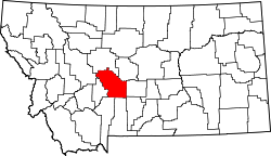
| County | Meagher |
| Elevation | 5,240 ft (1,600 m) |
| Time zone | UTC-7 (Mountain (MST)) |
| • Summer (DST) | UTC-6 (MDT) |
| ZIP code | 59053 |
| Area code | 406 |
| GNIS feature ID | 786050 [1] |
Lennep is a ghost town and populated place in Meagher County, Montana, United States.
Lennep has a still-active Lutheran church, and 3 inhabited houses (as of 2023). Closed buildings include a two-story general store/post office, and a K-8 school. Lennep is located at the foot of the Castle Mountains, and has a south view of the north end of the Crazy Mountains. Lennep is in the valley that divides the two ranges, that contains the South Fork of the Musselshell River. Lennep was once a station on the Old Milwaukee Road. A trackside signal can still be seen along Jawbone Road, where train tracks were removed over 30 years ago. The Lennep Mercantile housed the post office from the time the Mercantile opened in 1914; the post office had first opened in 1903 in a log home across the street. The post office was closed down in 1962.[ citation needed ]
Today Lennep is a sparsely occupied tourist attraction, with a number of buildings remaining and in reasonable condition, including the church, school, and store. Lennep is surrounded by beef cattle pastures/hay fields. There are still rural residences in the surrounding vicinity of Lennep, including substantial working ranches.