Payuk Lake is a glacial lake located nine kilometres (5.6 mi) southeast of Bakers Narrows, Manitoba, Canada.

The Mistik Creek is a stream in the Hudson Bay drainage basin in the Northern Region of Manitoba, Canada, approximately 20 kilometres (12 mi) northeast of Bakers Narrows.
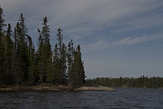
Neso Lake is a glacial lake on the Mistik Creek chain in the Hudson Bay drainage basin in the Northern Region of Manitoba, Canada. It sits in the Churchill River Upland portion of the Midwestern Canadian Shield forests which consist of mixed coniferous forest trees. The region around the lake consists of rocky parallel ridges with poorly drained areas of muskeg and irregular rocky shorelines due to intense glaciation. The lake is situated on the well known "Mistik Creek Loop", a remote canoe route which is 95 km (59 mi) in total length and can be paddled in four days.

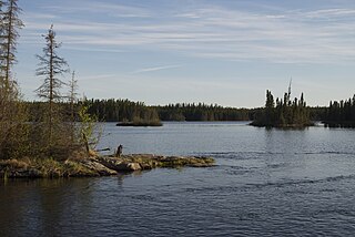
Nisto Lake is a glacial lake on the Mistik Creek chain in the Hudson Bay drainage basin in the Northern Region of Manitoba, Canada. It sits in the Churchill River Upland portion of the Midwestern Canadian Shield forests which consist of mixed deciduous and coniferous trees. The region around the lake consists of rocky parallel ridges with poorly drained areas of muskeg and irregular rocky shorelines due to intense glaciation. The lake is situated on the well-known "Mistik Creek Loop", a remote canoe route which is 80 km in total length can be paddled in four days.
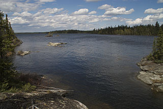
Nao Lake is a glacial lake on the Mistik Creek chain in the Hudson Bay drainage basin in the Northern Region of Manitoba, Canada. It sits in the Churchill River Upland portion of the Midwestern Canadian Shield forests which consist of mixed deciduous and coniferous trees. The region around the lake consists of rocky parallel ridges with poorly drained areas of muskeg and irregular rocky shorelines due to intense glaciation. The lake is situated on the well known "Mistik Creek Loop", a remote canoe route 95 kilometres (59 mi) in length which can be paddled in four days.

Niyanun Lake is a glacial lake on the Mistik Creek chain in the Hudson Bay drainage basin in the Northern Region of Manitoba, Canada.

Nikotwasik Lake is narrow glacial lake on the Mistik Creek chain beneath the Vamp Creek confluence. It is in the Hudson Bay drainage basin in the Northern Region of Manitoba, Canada. It sits in the Churchill River Upland portion of the Midwestern Canadian Shield forests which consist of mixed deciduous and coniferous trees.

Tapukok Lake is narrow glacial lake on the Mistik Creek chain above the Vamp Creek confluence. It is approximately 19 kilometres (12 mi) northeast of Bakers Narrows and is situated in the Hudson Bay drainage basin in the Northern Region of Manitoba, Canada. It is surrounded by the Churchill River Upland portion of the Midwestern Canadian Shield forests which consist of mixed deciduous and coniferous trees.

Uyenanao Lake is a glacial lake on the Mistik Creek chain, approximately 20 kilometres (12 mi) northeast of Bakers Narrows. It is part of the Nelson River watershed, in the Hudson Bay drainage basin in the Northern Region of Manitoba, Canada. The surrounding mixed deciduous and coniferous forest is part of the Churchill River Upland portion of the Midwestern Canadian Shield forests. The region around the lake consists of rocky parallel ridges with poorly drained areas of muskeg and irregular stony shorelines due to intense glaciation. The lake is situated on the well known "Mistik Creek Loop", a remote canoe route 80 kilometres (50 mi) in length which can be paddled in four days.

Kakat Lake is a glacial lake at the confluence of Holt Lake and Mistik Creek, approximately 21 kilometres (13 mi) northeast of Bakers Narrows. As a segment of the Mistik Creek, it is part of the Nelson River watershed, in the Hudson Bay drainage basin in the Northern Region of Manitoba, Canada. The surrounding mixed deciduous and coniferous forest is part of the Churchill River Upland portion of the Midwestern Canadian Shield forests. The region around the lake consists of rocky parallel ridges with poorly drained areas of muskeg and irregular stony shorelines due to intense glaciation. The lake is situated on the well known "Mistik Creek Loop", a remote canoe route 95 kilometres (59 mi) in length which can be paddled in four days.

Mitatut Lake is a glacial lake above the confluence of Holt Lake and Mistik Creek, approximately 21 kilometres (13 mi) northeast of Bakers Narrows. As a segment of the Mistik Creek, it is part of the Nelson River watershed, in the Hudson Bay drainage basin in the Northern Region of Manitoba, Canada. The surrounding mixed deciduous and coniferous forest is part of the Churchill River Upland portion of the Midwestern Canadian Shield forests. The region around the lake consists of rocky parallel ridges with poorly drained areas of muskeg and irregular stony shorelines due to intense glaciation. The lake is situated on the well known "Mistik Creek Loop", a remote canoe route 80 kilometres (50 mi) in length which can be paddled in four days.

Payukosap Lake is a glacial lake above the confluence of Holt Lake and Mistik Creek, approximately 23 kilometres (14 mi) northeast of Bakers Narrows. As a segment of the Mistik Creek, it is part of the Nelson River watershed, in the Hudson Bay drainage basin in the Northern Region of Manitoba, Canada. The surrounding mixed deciduous and coniferous forest is part of the Churchill River Upland portion of the Midwestern Canadian Shield forests. The region around the lake consists of rocky parallel ridges with poorly drained areas of muskeg and irregular stony shorelines due to intense glaciation. The lake is situated on the well known "Mistik Creek Loop", a remote canoe route 80 kilometres (50 mi) in length which can be paddled in four days.

Nesosap Lake is a glacial lake on the Mistik Creek chain, approximately 21 kilometres (13 mi) northeast of Bakers Narrows. As a segment of the Mistik Creek, it is part of the Nelson River watershed, in the Hudson Bay drainage basin in the Northern Region of Manitoba, Canada.

Nistosap Lake is a glacial lake on the Mistik Creek chain, approximately 22 kilometres (14 mi) northeast of Bakers Narrows. As a segment of the Mistik Creek, it is part of the Nelson River watershed, in the Hudson Bay drainage basin in the Northern Region of Manitoba, Canada.
Naosap Lake is a glacial lake in Canada, located approximately 28 kilometres (17 mi) northeast of Bakers Narrows, Manitoba. As the source of the Mistik Creek, it is part of the Nelson River watershed, in the Hudson Bay drainage basin in the Northern Region of Manitoba.

Holt Lake is a glacial lake that drains into the Kakat Lake, approximately 20 kilometres (12 mi) northeast of Bakers Narrows. As a tributary of Mistik Creek, it is part of the Nelson River watershed, in the Hudson Bay drainage basin in the Northern Region of Manitoba, Canada. The lake sits in Churchill River Upland portion of the Midwestern Canadian Shield forests and is surrounded by mixed forest with stands of black spruce, white spruce, jack pine, and trembling aspen. The shoreline is characterized by steeply sloping irregular rock ridges and poorly drained areas of muskeg.
Alberts Lake is a glacial lake approximately 17 km (11 mi) north-east of Bakers Narrows which drains into Thompson Lake. It is part of the Nelson River watershed, in the Hudson Bay drainage basin in Northern Manitoba, Canada.

Vamp Creek is a river in the Hudson Bay drainage basin in the Northern Region of Manitoba, Canada, approximately 25 kilometres (16 mi) north-east of Bakers Narrows.

Naosap Mud Lake is a small glacial lake approximately 22 kilometres (14 mi) northeast of Bakers Narrows which drains into Naosap Lake. It is part of the Nelson River watershed, in the Hudson Bay drainage basin in the Northern Region of Manitoba, Canada.
Goose River is a river in the Hudson Bay drainage basin in the Northern Region of Manitoba and Division No. 18 in Saskatchewan, Canada, approximately 19 kilometres (12 mi) south-east of Bakers Narrows.


