Umbozero is a Soviet Naval Aviation and Russian Navy reserve airfield in Murmansk Oblast, Russia located in the southwest Kola Peninsula 3 km north of Umbozero. It is located 165 km southeast of Murmansk. This airfield provides 20 revetments for combat aircraft.

Khrabrovo Airport, also appearing in historical documents as Povunden Airfield, is the airport of Kaliningrad, located 24 kilometers (15 mi) north of the city near the village of Khrabrovo. While it mostly serves scheduled domestic destinations, part of it is still a military base of the Russian Air Force.

Olenya is a major Russian Navy reconnaissance base, located on the Kola Peninsula 92 km south of Murmansk. The base and its staff settlement across the Lake Permusozero from the city of Olenegorsk, and are served by the Olenegorsk rail station. Olenya serves as the headquarters for 5 MRAD and is host to two reconnaissance regiments. Its 3500-meter runway is the longest on the Kola Peninsula, making it a key facility for intercontinental flights across the North Atlantic basin.

Provideniya Bay Airport is a small airport in Chukotka, Russia located 3 km southwest of Provideniya. It services primarily small transport aircraft. A concrete apron contains four parking spaces.

Sharomy is a Naval air base in Kamchatka Krai, Russia located about 143 km north of Petropavlovsk-Kamchatsky. Sharomy contains hardstands for 12 bombers and 3 fighters. It is believed to serve as a dispersal airfield for Soviet Naval Aviation, and may also be a staging airfield for Long Range Aviation.

Vorkuta Sovetskiy is a military airfield in the Komi Republic, Russia located 11 km east of Vorkuta. It was one of nine Air Army staging bases in the Arctic for Russian bomber units. It contains one of the largest runways in Russia's Arctic region.

Maysionvara is a former air base in Russia located 22 km north of Suojarvi. A 1962 US satellite analysis showed a 2560 m (8400 ft) runway with no aircraft on the field. It was shown on the 1974 version of Department of Defense Global Navigation Chart No. 3 as having jet facilities. It was likely either a dispersal field or an active military base during the early Cold War era and was closed by the 1960s or 1970s.
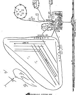
Smirnykh is an abandoned Soviet airbase in Sakhalin, Russia located 2 km east of the village of the same name. It appeared in June 1966 KH-7 imagery with a runway length of 2,000 m. It was expanded sometime after this to 2,500 m with a new extension of revetments added.
Klyuchi Air Base is in Kamchatka Krai, Russia located 3 kilometers (1.9 mi) southwest of the settlement of Klyuchi. It is a small but significant interceptor airfield covering northern Kamchatka, probably to defend international borders during nearby missile testing operations at Kura Missile Test Range 130 km to the northeast. Klyuchi contains about twelve fighter revetments and some narrow tarmac space. It is an active military base; Google high-res imagery shows some An-24 and other transports, along with helicopters.
Matrosovo is a former air base on Sakhalin Island, Russia located 14 km north of Leonidovo. It served as a dispersal airfield for military aircraft on Sakhalin Island during the Cold War.
Kaliningrad Chkalovsk is a naval air base in Chkalovsk, Kaliningrad Oblast, Russia located 9 kilometers northwest of Kaliningrad. Most instances in Russian aviation literature of Chkalovsk or Chkalovskoye refer specifically to this large airfield. It is Kaliningrad's largest airfield, a significant Baltic naval base with four separate complexes for bomber and fighter parking.
Marienkhof (German) is an air base in Kaliningrad Oblast, Russia located 10 km south of Pionersky. It was in use during the 1950s and has been abandoned near the end of the Cold War. It has a spartan layout, unimproved pads, if any, and an alert strip feeding directly onto the runway threshold.
Vozzhayevka is an air base in Amur Oblast, Russia located about 100 km southeast of Blagoveshchensk. It is a medium-sized air base located near an SS-11 missile field at Svobodnyy. During the 1980s it was one of 17 airfields hosting the Soviet Union's tactical reconnaissance aircraft regiments.

Uglovoye,, known in the US intelligence community as Uglovoye Northwest, is an air base in Primorsky Krai located close to the town of Artyom, Russia. This is the primary air defense base for the Vladivostok area, and it was home to the PVO Strany division headquarters for the Vladivostok region

Verino airfield was a Soviet Air Force base in Khabarovsk Krai, Russia located 5 km (3 mi) northeast of Pereyaslavka, Russia and about 35 miles (55 km) south of Khabarovsk. Verino was an 11th Air Army airfield, with the 300 and 302nd Bomber Aviation Regiment a mainstay in later years.

Blagodatnoye is an abandoned Soviet airbase in Khabarovsk Krai, Russia located 23 km east of Khabarovsk near the town of Kalinka. It was part of the Soviet Air Defence Forces Far Eastern Military District and hosted an interceptor regiment flying Sukhoi Su-9 (Fishpot) and MiG-17 (Fresco) aircraft. It was closed as a military base in 2009.

Maykhe, also given as Mayke, is an abandoned military air base of the Soviet Air Force in Primorsky Krai, Russia. It is located about 20 km east of the town of Artyom. It was identified by Western intelligence as early as 1962, and in 1971 it was linked to a missile facility northeast of the airfield.

Novorossiya is an abandoned military air base of the Soviet Air Force in Primorsky Krai, Russia, located 29 km east of Artyom.
Korsakov was a Soviet Naval Aviation reserve airfield on Sakhalin, Russia located 11 km (7 mi) northeast of Korsakov. It was first listed by US intelligence in 1964, when significant construction of the runway was underway. Due to the long runway length it was likely intended for dispersal of Tupolev Tu-16R medium reconnaissance jets, and may have been built to meet Defense Minister Rodion Malinovsky's directive that every American aircraft carrier between Midway Island and the Kuril Ridge be photographed by Soviet Tupolev Tu-16R reconnaissance aircraft.

Kupino is a military air base in Novosibirsk Oblast, Russia. It is located 4 km southeast of the town of the same name. It largely served the interceptor air defense role for the Soviet Air Force.


