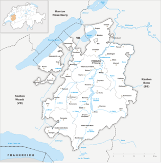
The canton of Fribourg, also canton of Freiburg is located in western Switzerland. The canton is bilingual, with French spoken by more than two thirds of the citizens and German by a little more than a quarter. Both are official languages in the canton. The canton takes its name from its capital city of Fribourg.

Les Portes du Soleil is a major skisports destination in the Alps, encompassing thirteen resorts between Mont Blanc in France and Lake Geneva in Switzerland. With more than 650 km of marked pistes and about 200 lifts in total, spread over 14 valleys and about 1,036 square kilometres (400 sq mi), Portes du Soleil ranks among the two largest ski areas in the world. Almost all of the pistes are connected by lifts – a few marginal towns can be reached only by the free bus services in the area. The highest altitude accessible on skis is 2260m and the lowest is 930m. As with many other Alpine ski resorts, the lower slopes of the Portes du Soleil have snow-making facilities to extend the ski season by keeping the lower slopes open during the warmer months.

There are 126 municipalities in the canton of Fribourg, Switzerland.

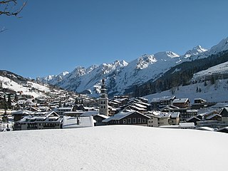
Verbier is a village located in south-western Switzerland in the canton of Valais. It is a holiday resort and ski area in the Swiss Alps and is recognised as one of the premier off-piste resorts in the world. Some areas are covered with snow all year. Skiers have settled in the Verbier area in order to take advantage of the steep slopes, varied conditions, and resort culture.
Châtel is a commune on the Swiss border in the Haute-Savoie department in the Auvergne-Rhône-Alpes region in Southeastern France. In 2019, it had a population of 1,246. Situated in the northern part of the French Alps, Châtel is part of the French-Swiss ski domain known as Portes du Soleil. Despite its development into a major ski resort, the village still retains many of its traditional alpine characteristics.
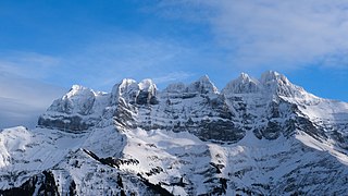
The Dents du Midi are a three-kilometre-long mountain range in the Chablais Alps in the canton of Valais, Switzerland. Overlooking the Val d'Illiez and the Rhône valley to the south, they face the Lac de Salanfe, an artificial reservoir, and are part of the geological ensemble of the Giffre massif. Their seven peaks are, from north-east to south-west: the Cime de l'Est, the Forteresse, the Cathédrale, the Éperon, the Dent Jaune, the Doigts and the Haute Cime. They are mainly composed of limestone rock, with gritty limestone rock in the upper parts.

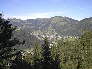
Châtel-Saint-Denis is a municipality and district capital of the district of Veveyse in the canton of Fribourg in Switzerland.

Avoriaz is a French mountain resort in the heart of the Portes du Soleil. It is located in the territory of the commune of Morzine. It is easily accessible from either Thonon at Lake Geneva or Cluses station on the A40 motorway between Geneva and Chamonix. Either way one follows the D902, Route des Grandes Alpes, to Morzine and then the D338 running from Morzine to Avoriaz. Snow chains are often necessary. Avoriaz is built on a shelf high above the town of Morzine, which is among the pioneering towns of skiing with its first lifts dating back to the early 1930s. Today Avoriaz is one of the major French ski destinations catering for all standards of skiing and ranks among the top snowboarding destinations of the world. Apart from snow-based pursuits, Avoriaz is also a centre for trekking, golf, VTT and other outdoor activities during the summer. Cars are forbidden in Avoriaz. The resort is designed to be fully skiable. Other transport around the resort includes horse-drawn sleighs and snowcats during winter.
La Clusaz is a commune in the Haute-Savoie department in the Auvergne-Rhône-Alpes region in south-eastern France.

La Tzoumaz is a ski resort in the Swiss Alps, in the canton of Valais. It is part of the "Four Valleys" ski area, which consists of various ski resorts, including Verbier, Nendaz, Veysonnaz, La Tzoumaz, and Thyon. As such it has direct access to over 400 km of runs. Named after the word "tzoumer", meaning taking a break, La Tzoumaz nestles against the same mountain as Verbier, Mont Savolyres, and is at the same altitude (1500m). However, unlike Verbier, it is situated on north-facing slopes and hence enjoys a longer ski-season, lasting from early December all the way through to late-April. The resort has splendid views over the Rhone valley from the side of a small sunny valley on the north side of Verbier.
Lac de Lussy is a lake in the bog at Châtel-Saint-Denis, in the canton of Fribourg, Switzerland. Lake and bog are part of a nature preserve, listed in the Inventory of Mire Landscapes of Particular Beauty and National Importance.

The Vallée de Joux is a valley of the Jura Mountains mainly in the Swiss Canton of Vaud. The valley also continues into France at its higher, southwestern, end. Located 30 miles (48 km) north of Geneva and northwest of Lausanne, its mean elevation is over 3,300 feet (1,000 m). There are three Swiss lakes in the Vallée de Joux: the lac de Joux, the lac Brenet and Lake Ter. The French border runs along the northern edge of the valley until, about 10 kilometres (6.2 mi) west of the lac de Joux, the base of the valley becomes French territory. The valley then continues to climb gently towards the Lac des Rousses and the ski resort of Les Rousses.

The Dent de Lys is a mountain in the Bernese Alps, in the canton of Fribourg.

Les Crosets is a village and ski resort in the Canton of Valais, Switzerland. It is part of the Val-d'Illiez municipality, and Portes du Soleil ski area.
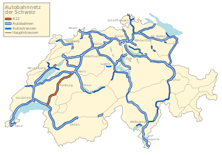
The A12 motorway, an Autobahn in western Switzerland, is a divided highway connecting the A9 to the A1.
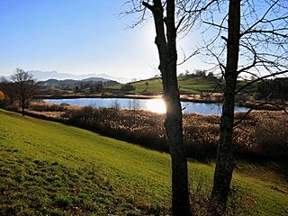
The lac des Joncs is a small mountain lake located in Les Paccots, canton of Fribourg, in Switzerland.

The Niremont is a mountain of the Swiss Prealps, in the canton of Fribourg. Due to its rounded shape, it has 2 sub-summits : The Gros Niremont and the Petit Niremont.

Corbetta is a mountain of the Swiss Prealps, in the canton of Fribourg.
Le Rathvel is a small ski resort of the Swiss Prealps, located in the canton of Fribourg.
RER Fribourg or RER Fribourg | Freiburg is an S-Bahn network in the canton of Fribourg in Switzerland. The network has two hubs, Bulle and Fribourg, and began operating in 2011.
